File:Ireland in Irish.jpg
Jump to navigation
Jump to search

Size of this preview: 497 × 599 pixels. Other resolutions: 199 × 240 pixels | 398 × 480 pixels | 676 × 815 pixels.
Original file (676 × 815 pixels, file size: 136 KB, MIME type: image/jpeg)
Captions
Captions
Add a one-line explanation of what this file represents
Summary
[edit]
| Description |
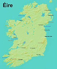
English: It is really difficult to find a map of the island of Éire (Ireland), without political borders, in Gaeilge (the Irish language). The most noticeable feature of this map (conspicuously absent) is the line that divides the Republic of Ireland from Northern Ireland. The border was created in 1921 by the British. In the 300 years prior, the British Crown had been colonizing Éire, confiscating land and granting it to settlers from Britain.
Gaeilge speakers are now a minority on their own island, and most of the places are now better known by their English names. This map imagines a unified island in its native language. |
| Date | |
| Source | https://decolonialatlas.wordpress.com/2014/11/06/ireland-in-irish/ |
| Author | Jordan Engel |
Licensing
[edit]
This file is licensed under the Creative Commons Attribution-Share Alike 4.0 International license.
- You are free:
- to share – to copy, distribute and transmit the work
- to remix – to adapt the work
- Under the following conditions:
- attribution – You must give appropriate credit, provide a link to the license, and indicate if changes were made. You may do so in any reasonable manner, but not in any way that suggests the licensor endorses you or your use.
- share alike – If you remix, transform, or build upon the material, you must distribute your contributions under the same or compatible license as the original.
File history
Click on a date/time to view the file as it appeared at that time.
| Date/Time | Thumbnail | Dimensions | User | Comment | |
|---|---|---|---|---|---|
| current | 03:48, 31 December 2019 | | 676 × 815 (136 KB) | Myrhonon (talk | contribs) | User created page with UploadWizard |
You cannot overwrite this file.
File usage on Commons
The following page uses this file:
File usage on other wikis
The following other wikis use this file:
- Usage on ku.wikipedia.org