File:Intercitynet NL 2012.png
Jump to navigation
Jump to search

Size of this preview: 507 × 599 pixels. Other resolutions: 203 × 240 pixels | 406 × 480 pixels | 650 × 768 pixels | 866 × 1,024 pixels | 1,686 × 1,993 pixels.
Original file (1,686 × 1,993 pixels, file size: 128 KB, MIME type: image/png)
Captions
Captions
Add a one-line explanation of what this file represents
Summary
[edit]
| Description |
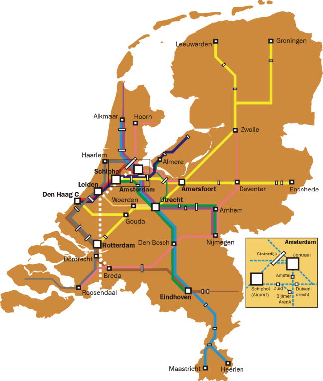
English: Map of the Dutch Intercity network. Thin lines are used for all-stops services that are a continuation of intercity services (e.g. the Rotterdam-Gouda-Amsterdam leg of the Enkhuizen-Rotterdam trains, and the Roosendaal - Vlissingen leg of the Amsterdam-Vlissingen trains).
Further notes:
|
| Date | |
| Source | Own work |
| Author | Classical geographer |
Licensing
[edit]
I, the copyright holder of this work, hereby publish it under the following licenses:
This file is licensed under the Creative Commons Attribution-Share Alike 3.0 Unported license.
- You are free:
- to share – to copy, distribute and transmit the work
- to remix – to adapt the work
- Under the following conditions:
- attribution – You must give appropriate credit, provide a link to the license, and indicate if changes were made. You may do so in any reasonable manner, but not in any way that suggests the licensor endorses you or your use.
- share alike – If you remix, transform, or build upon the material, you must distribute your contributions under the same or compatible license as the original.

|
Permission is granted to copy, distribute and/or modify this document under the terms of the GNU Free Documentation License, Version 1.2 or any later version published by the Free Software Foundation; with no Invariant Sections, no Front-Cover Texts, and no Back-Cover Texts. A copy of the license is included in the section entitled GNU Free Documentation License. |
You may select the license of your choice.
File history
Click on a date/time to view the file as it appeared at that time.
| Date/Time | Thumbnail | Dimensions | User | Comment | |
|---|---|---|---|---|---|
| current | 19:44, 11 January 2012 | | 1,686 × 1,993 (128 KB) | Classical geographer (talk | contribs) | Now uploaded correct version, indeed without Best. |
| 19:03, 14 November 2011 |  | 1,686 × 1,993 (128 KB) | Classical geographer (talk | contribs) | Added Delft and Schiedam, removed Best. | |
| 17:37, 5 August 2011 |  | 1,686 × 1,993 (523 KB) | Classical geographer (talk | contribs) | Updated to 2012. | |
| 17:36, 5 August 2011 |  | 4,216 × 4,984 (439 KB) | Classical geographer (talk | contribs) | Updated to 2012. | |
| 14:57, 16 October 2009 |  | 2,810 × 3,323 (610 KB) | T n g old commons (talk | contribs) | De intercity naar venlo rijdt pas na Deurne als stoptrein. Na eindhoven skipt hij nog de stations Helmond Brandevoort en Helmond 't Hout, waarnaar de intercity stopt op station helmond, en daarna weer station Brouwhuis skipt, dan stopt hij op deurne, wat | |
| 16:45, 12 March 2009 |  | 2,810 × 3,323 (511 KB) | Classical geographer (talk | contribs) | {{Information |Description={{en|1=Map of the Dutch Intercity network. Narrower lines are intercities that run an all-stops service. (On the Rotterdam-Gouda-Amsterdam line, the intercity is even officially called Stoptrein, but it is still indicated here.) |
You cannot overwrite this file.
File usage on Commons
The following 2 pages use this file:
- User:Classical geographer
- File:Intercitynet NL.png (file redirect)
File usage on other wikis
The following other wikis use this file:
- Usage on ja.wikipedia.org
- Usage on nl.wikipedia.org