File:Inner Montgomery County map.svg
Jump to navigation
Jump to search

Size of this PNG preview of this SVG file: 733 × 599 pixels. Other resolutions: 294 × 240 pixels | 587 × 480 pixels | 939 × 768 pixels | 1,253 × 1,024 pixels | 2,505 × 2,048 pixels | 943 × 771 pixels.
Original file (SVG file, nominally 943 × 771 pixels, file size: 1.76 MB)
Captions
Captions
Add a one-line explanation of what this file represents

|
This file was moved to Wikimedia Commons from wts.oldwikivoyage using a bot script. All source information is still present. It requires review. Additionally, there may be errors in any or all of the information fields; information on this file should not be considered reliable and the file should not be used until it has been reviewed and any needed corrections have been made. Once the review has been completed, this template should be removed. For details about this file, see below. Check now! |
Summary
[edit]
| Description |
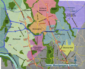
Inner Montgomery County suburbs map, Maryland. SVG, Montgomery County (Maryland)
PNG files: |
| Date | |
| Source | OpenStreetMap [1] |
| Author | Peter Fitzgerald, OpenStreetMap [2] |
Licensing
[edit]
This file is licensed under the Creative Commons Attribution 3.0 Unported license.
- You are free:
- to share – to copy, distribute and transmit the work
- to remix – to adapt the work
- Under the following conditions:
- attribution – You must give appropriate credit, provide a link to the license, and indicate if changes were made. You may do so in any reasonable manner, but not in any way that suggests the licensor endorses you or your use.
Original upload log
[edit]
| This file was imported from Wikivoyage WTS. |
The original description page was here. All following user names refer to wts.wikivoyage-old.
- 2010-03-22 04:14 (WT-shared) Peterfitzgerald archive copy at the Wayback Machine 943×771 (1837263 bytes) == Summary == {{Imagecredit|credit=Peter Fitzgerald, OpenStreetMap [http://openstreetmap.org]|captureDate=22 March 2010|location=Montgomery (Import from wikitravel.org/shared)
- 2011-08-05 00:33 (WT-shared) Peterfitzgerald archive copy at the Wayback Machine 943×771 (1849914 bytes) (Import from wikitravel.org/shared)
File history
Click on a date/time to view the file as it appeared at that time.
| Date/Time | Thumbnail | Dimensions | User | Comment | |
|---|---|---|---|---|---|
| current | 04:00, 14 December 2012 | | 943 × 771 (1.76 MB) | OgreBot (talk | contribs) | (BOT): Reverting to most recent version before archival |
| 04:00, 14 December 2012 |  | 943 × 771 (1.75 MB) | OgreBot (talk | contribs) | (BOT): Uploading old version of file from wts.wikivoyage; originally uploaded on 2010-03-22 04:14:36 by (WT-shared) Peterfitzgerald | |
| 00:10, 18 November 2012 |  | 943 × 771 (1.76 MB) | MGA73bot2 (talk | contribs) | {{BotMoveToCommons|wts.oldwikivoyage|year={{subst:CURRENTYEAR}}|month={{subst:CURRENTMONTHNAME}}|day={{subst:CURRENTDAY}}}} == {{int:filedesc}} == {{Information |description=Inner Montgomery County suburbs map, Maryland. SVG, Montgomery County (Marylan... |
You cannot overwrite this file.
File usage on Commons
The following page uses this file: