File:Imia delimitation 1932.svg
Jump to navigation
Jump to search

Size of this PNG preview of this SVG file: 576 × 600 pixels. Other resolutions: 230 × 240 pixels | 461 × 480 pixels | 737 × 768 pixels | 983 × 1,024 pixels | 1,966 × 2,048 pixels | 602 × 627 pixels.
Original file (SVG file, nominally 602 × 627 pixels, file size: 98 KB)
Captions
Captions
Add a one-line explanation of what this file represents
Summary
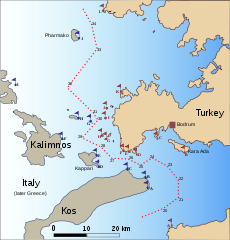
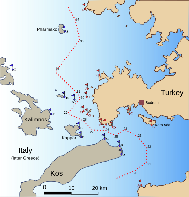
[edit]| Description | Map of the area around Imia/Kardak, showing the demarcation line of the 1932 border protocol between Turkey and Italy, claimed today by Greece as the international boundary. Numbers next to the demarcation line and flagged points refer to the list of defining geographical points as stated in the protocol. |
| Date | |
| Source | Own work |
| Author | w:en:User:Future Perfect at Sunrise |
| Other versions |
[]
|


Legend
[edit]
- Turkish side
| Point | Name in text of 1932 protocol | Modern name |
|---|---|---|
| A | Mordala I. | |
| B | le point S.E. (ecueil - Kara Ada) | Kara Ada, southeast point |
| C | Guirejik I. | Gürecik Adası |
| D | Utchian I. | Kargı Adası |
| E | Arkialla Pt. | |
| F | Hussein Pt. | Hüseyin Burnu |
| G | Lodo | Yassıada |
| H | Atsaki | Topan Adası (Gr. Zouka) |
| I | Kato I. | Çavuş Adası |
| J | Pondikusa | Büyükkiremit Adası |
| K | Sandama Peninsula | İnce Burnu |
| L | C. Monodendri | Tekeağaç |
- Italian (later Greek) side
| Point | Name in text of 1932 protocol | Modern name |
|---|---|---|
| A | C. Phuka | Ag. Fokas |
| B | Luro Pt | Akr. Psalidi |
| C | Kum Pt. | Akr. Ammoglossa |
| D | C. Russa (Kappari) | Akr. Roussa (Pserimos) |
| E | Vasiliki Pt. (Kappari) | Vasiliki (Pserimos) |
| F | Karapsili Pt. (Kalimno) | Akr. Atsipas |
| G | Kardak (Rks) | Imia/Kardak |
| H | le phare de Kalolimno | Kalolimnos |
| I | Agia Kiriaki | Ag. Kiriaki |
| J | la pointe S.E. de l'îsle de Pharmako | Farmakonisi |
Source: Text of the 1932 treaty and border protocol, and modern maps of the area.
Licensing
[edit]
I, the copyright holder of this work, hereby publish it under the following licenses:

|
Permission is granted to copy, distribute and/or modify this document under the terms of the GNU Free Documentation License, Version 1.2 or any later version published by the Free Software Foundation; with no Invariant Sections, no Front-Cover Texts, and no Back-Cover Texts. A copy of the license is included in the section entitled GNU Free Documentation License. |
| This file is licensed under the Creative Commons Attribution-Share Alike 3.0 Unported license. | ||
| ||
| This licensing tag was added to this file as part of the GFDL licensing update. |
This file is licensed under the Creative Commons Attribution-Share Alike 2.5 Generic, 2.0 Generic and 1.0 Generic license.
- You are free:
- to share – to copy, distribute and transmit the work
- to remix – to adapt the work
- Under the following conditions:
- attribution – You must give appropriate credit, provide a link to the license, and indicate if changes were made. You may do so in any reasonable manner, but not in any way that suggests the licensor endorses you or your use.
- share alike – If you remix, transform, or build upon the material, you must distribute your contributions under the same or compatible license as the original.
You may select the license of your choice.

|
This SVG file contains embedded text that can be translated into your language, using any capable SVG editor, text editor or the SVG Translate tool. For more information see: About translating SVG files. |
File history
Click on a date/time to view the file as it appeared at that time.
| Date/Time | Thumbnail | Dimensions | User | Comment | |
|---|---|---|---|---|---|
| current | 06:34, 30 January 2007 | | 602 × 627 (98 KB) | Future Perfect at Sunrise (talk | contribs) | |
| 13:19, 28 January 2007 |  | 1,454 × 1,370 (115 KB) | Future Perfect at Sunrise (talk | contribs) | ||
| 13:08, 28 January 2007 |  | 1,454 × 1,370 (119 KB) | Future Perfect at Sunrise (talk | contribs) | ||
| 00:37, 28 January 2007 |  | 1,454 × 1,370 (89 KB) | Future Perfect at Sunrise (talk | contribs) | {{Information |Description=Map of the area around Imia (Kardak), showing the demarcation line of the 1932 border protocol between Turkey and Italy, claimed today by Greece as the international boundary. Numbers next to the demarcation |
You cannot overwrite this file.
File usage on Commons
The following 4 pages use this file:
File usage on other wikis
The following other wikis use this file:
- Usage on de.wikipedia.org
- Usage on el.wikipedia.org
- Usage on en.wikipedia.org
- Usage on fi.wikipedia.org
- Usage on fr.wikipedia.org
- Usage on tr.wikipedia.org