File:Hurricane Otto at landfall over Nicaragua.gif
Jump to navigation
Jump to search
No higher resolution available.
Hurricane_Otto_at_landfall_over_Nicaragua.gif (720 × 480 pixels, file size: 2.6 MB, MIME type: image/gif, looped, 15 frames, 3.1 s)
Captions
Captions
Add a one-line explanation of what this file represents
Summary
[edit]
| Description |
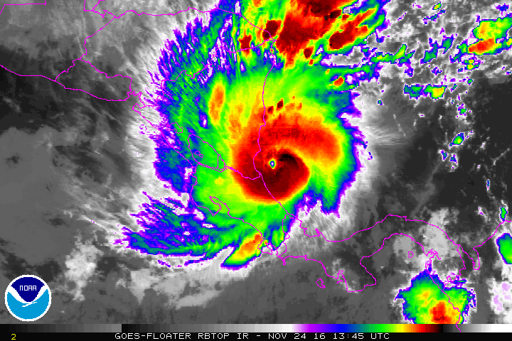
English: The infrared GOES-13 satellite loop with RBTOP enhancements presents Hurricane Otto in November 24, 2016 at its peak intensity and its landfall over southeastern Nicaragua.
Español: Las imagenes animadas de satélite, procesadas en RBTOP, muestran al huracán Otto el 24 de noviembre de 2016 en su pico de intensidad y su interacción con tierra sobre el sureste de Nicaragua. |
| Date | |
| Source | http://www.ssd.noaa.gov/PS/TROP/floaters/ |
| Author | National Oceanic and Atmospheric Administration |
Licensing
[edit]
This image is in the public domain because it contains materials that originally came from the U.S. National Oceanic and Atmospheric Administration, taken or made as part of an employee's official duties.
|
File history
Click on a date/time to view the file as it appeared at that time.
| Date/Time | Thumbnail | Dimensions | User | Comment | |
|---|---|---|---|---|---|
| current | 05:47, 30 January 2017 | | 720 × 480 (2.6 MB) | Byralaal (talk | contribs) | User created page with UploadWizard |
You cannot overwrite this file.
File usage on Commons
The following page uses this file:
File usage on other wikis
The following other wikis use this file:
- Usage on en.wikipedia.org
- Usage on es.wikipedia.org
- Usage on id.wikipedia.org
- Usage on pt.wikipedia.org
- Usage on ru.wikipedia.org
- Usage on uk.wikipedia.org