File:Hubbard County Minnesota Native Vegetation pie chart.pdf
Jump to navigation
Jump to search

Size of this JPG preview of this PDF file: 776 × 600 pixels. Other resolutions: 311 × 240 pixels | 621 × 480 pixels | 994 × 768 pixels | 1,280 × 989 pixels | 1,650 × 1,275 pixels.
Original file (1,650 × 1,275 pixels, file size: 32 KB, MIME type: application/pdf)
Captions
Captions
Add a one-line explanation of what this file represents
Summary
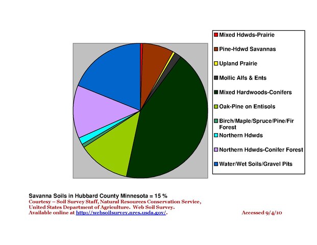
[edit]This pie chart gives a quick look at proportions of native vegetation in Hubbard County Minnesota.
Licensing
[edit]This file is licensed under the Creative Commons Attribution-Share Alike 3.0 Unported license.
- You are free:
- to share – to copy, distribute and transmit the work
- to remix – to adapt the work
- Under the following conditions:
- attribution – You must give appropriate credit, provide a link to the license, and indicate if changes were made. You may do so in any reasonable manner, but not in any way that suggests the licensor endorses you or your use.
- share alike – If you remix, transform, or build upon the material, you must distribute your contributions under the same or compatible license as the original.
Category:Earth Sciences/Soil Science/Native Vegetation/Minnesota
File history
Click on a date/time to view the file as it appeared at that time.
| Date/Time | Thumbnail | Dimensions | User | Comment | |
|---|---|---|---|---|---|
| current | 12:12, 20 August 2013 |  | 1,650 × 1,275 (32 KB) | Firry Floyd (talk | contribs) | This pie chart gives a quick look at proportions of native vegetation in Hubbard County Minnesota. |
You cannot overwrite this file.
File usage on Commons
There are no pages that use this file.