File:Hornekarta1784.jpg
Jump to navigation
Jump to search

Size of this preview: 639 × 599 pixels. Other resolutions: 256 × 240 pixels | 512 × 480 pixels | 1,002 × 940 pixels.
Original file (1,002 × 940 pixels, file size: 264 KB, MIME type: image/jpeg)
Captions
Captions
Add a one-line explanation of what this file represents
Summary
[edit]
| Description |
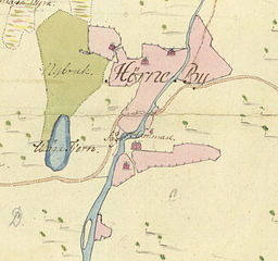
Svenska: Utsnitt ur "Charta öfwer Hörne och Bäcks byars samfälta skog (...) afmätt och till afvittring beredd uti junii månad år 1784." English: Part of map of the forests of the adjacent villages Hörne and Bäck in southern Västerbotten, Sweden, drawn in 1784. |
| Date | |
| Source | Lantmäteriet |
| Author | Anders Magnus Strinnholm |
Licensing
[edit]
|
This is a faithful photographic reproduction of a two-dimensional, public domain work of art. The work of art itself is in the public domain for the following reason:
The official position taken by the Wikimedia Foundation is that "faithful reproductions of two-dimensional public domain works of art are public domain".
This photographic reproduction is therefore also considered to be in the public domain in the United States. In other jurisdictions, re-use of this content may be restricted; see Reuse of PD-Art photographs for details. | ||||
File history
Click on a date/time to view the file as it appeared at that time.
| Date/Time | Thumbnail | Dimensions | User | Comment | |
|---|---|---|---|---|---|
| current | 08:04, 21 July 2013 | | 1,002 × 940 (264 KB) | Skogsfrun (talk | contribs) | User created page with UploadWizard |
You cannot overwrite this file.
File usage on Commons
There are no pages that use this file.
File usage on other wikis
The following other wikis use this file:
- Usage on sv.wikipedia.org