File:Hong Kong Railway Route Map ring.pdf
Jump to navigation
Jump to search

Size of this JPG preview of this PDF file: 600 × 600 pixels. Other resolutions: 240 × 240 pixels | 480 × 480 pixels | 768 × 768 pixels | 1,024 × 1,024 pixels | 2,048 × 2,048 pixels | 5,000 × 5,000 pixels.
Original file (5,000 × 5,000 pixels, file size: 924 KB, MIME type: application/pdf)
Captions
Captions
Add a one-line explanation of what this file represents
| Description |
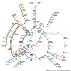
English: Hong Kong MTR diagram in concentric ring pattern, assuming East Kowloon Line and North Island Line are completed.
|
|||
| Date | 14 May 2016, 04:21:02 (upload date) | |||
| Source | Own work | |||
| Author | Sameboat | |||
| Permission (Reusing this file) |
I, the copyright holder of this work, hereby publish it under the following license: This file is licensed under the Creative Commons Attribution-Share Alike 4.0 International license.
|
|||
| Other versions |
|


File history
Click on a date/time to view the file as it appeared at that time.
| Date/Time | Thumbnail | Dimensions | User | Comment | |
|---|---|---|---|---|---|
| current | 00:03, 26 May 2018 |  | 5,000 × 5,000 (924 KB) | Sameboat (talk | contribs) | Tuen Ma Line |
| 09:12, 28 November 2017 | No thumbnail | 0 × 0 (871 KB) | Sameboat (talk | contribs) | ||
| 10:54, 12 June 2016 | No thumbnail | 0 × 0 (924 KB) | Sameboat (talk | contribs) | Add terminus line icon to make it colorblind-friendly | |
| 01:15, 31 May 2016 | No thumbnail | 0 × 0 (874 KB) | Sameboat (talk | contribs) | feOffset | |
| 03:30, 30 May 2016 | No thumbnail | 0 × 0 (875 KB) | Sameboat (talk | contribs) | + hollow line on Kwun Tong Line Whampoa section and Tseung Kwan O Line LOHAS Park section to denote irregular services; minor adjustments of line labels; cast shadow for eye candy | |
| 09:07, 19 May 2016 | No thumbnail | 0 × 0 (104 KB) | Sameboat (talk | contribs) | ||
| 07:48, 19 May 2016 | No thumbnail | 0 × 0 (104 KB) | Sameboat (talk | contribs) | + en:East Kowloon Line | |
| 23:02, 18 May 2016 | No thumbnail | 0 × 0 (106 KB) | Sameboat (talk | contribs) | ||
| 14:24, 18 May 2016 | No thumbnail | 0 × 0 (106 KB) | Sameboat (talk | contribs) | ||
| 09:53, 18 May 2016 | No thumbnail | 0 × 0 (102 KB) | Sameboat (talk | contribs) |
You cannot overwrite this file.
File usage on Commons
The following 30 pages use this file:
- User:Chumwa/OgreBot/Potential transport maps/2016 June 11-20
- User:Chumwa/OgreBot/Potential transport maps/2016 May 11-20
- User:Chumwa/OgreBot/Potential transport maps/2016 May 21-31
- User:Chumwa/OgreBot/Potential transport maps/2017 November 21-30
- User:Chumwa/OgreBot/Potential transport maps/2018 May 21-31
- User:Chumwa/OgreBot/Public transport information/2016 June 11-20
- User:Chumwa/OgreBot/Public transport information/2016 May 11-20
- User:Chumwa/OgreBot/Public transport information/2016 May 21-31
- User:Chumwa/OgreBot/Public transport information/2017 November 21-30
- User:Chumwa/OgreBot/Public transport information/2018 May 21-31
- User:Chumwa/OgreBot/Transport Maps/2016 June 11-20
- User:Chumwa/OgreBot/Transport Maps/2016 May 11-20
- User:Chumwa/OgreBot/Transport Maps/2016 May 21-31
- User:Chumwa/OgreBot/Transport Maps/2017 November 21-30
- User:Chumwa/OgreBot/Transport Maps/2018 May 21-31
- User:Chumwa/OgreBot/Travel and communication maps/2016 June 11-20
- User:Chumwa/OgreBot/Travel and communication maps/2016 May 11-20
- User:Chumwa/OgreBot/Travel and communication maps/2016 May 21-31
- User:Chumwa/OgreBot/Travel and communication maps/2017 November 21-30
- User:Chumwa/OgreBot/Travel and communication maps/2018 May 21-31
- User:OgreBot/Watercraft/2016 June 11-15
- User:OgreBot/Watercraft/2016 May 13-16
- User:OgreBot/Watercraft/2016 May 17-21
- User:OgreBot/Watercraft/2016 May 27-31
- User:OgreBot/Watercraft/2017 November 28
- User:OgreBot/Watercraft/2018 May 26
- User:Sameboat/MTR concentric ring map
- Commons:Featured picture candidates/File:Hong Kong Railway Route Map ring.pdf
- Commons:Featured picture candidates/Log/June 2016
- File:Hong Kong Railway Route Map ring.svg