File:Historic American Buildings Survey Photo from Drawing in U.S. District Court Original- August 1854 Re-photo- April 1938 PLAT OF 1854 - Mission San Jose de Guadalupe, Mission and HABS CAL,1-FREMO,1-21.tif
Jump to navigation
Jump to search

Size of this JPG preview of this TIF file: 800 × 573 pixels. Other resolutions: 320 × 229 pixels | 640 × 459 pixels | 1,024 × 734 pixels | 1,280 × 918 pixels | 2,560 × 1,835 pixels | 5,000 × 3,584 pixels.
Original file (5,000 × 3,584 pixels, file size: 17.09 MB, MIME type: image/tiff)
Captions
Captions
Add a one-line explanation of what this file represents
Summary
[edit]| Historic American Buildings Survey Photo from Drawing in U.S. District Court Original- August 1854 Re-photo- April 1938 PLAT OF 1854 - Mission San Jose de Guadalupe, Mission and Washington Boulevards, Fremont, Alameda County, CA | ||||
|---|---|---|---|---|
| Title |
Historic American Buildings Survey Photo from Drawing in U.S. District Court Original- August 1854 Re-photo- April 1938 PLAT OF 1854 - Mission San Jose de Guadalupe, Mission and Washington Boulevards, Fremont, Alameda County, CA |
|||
| Description |
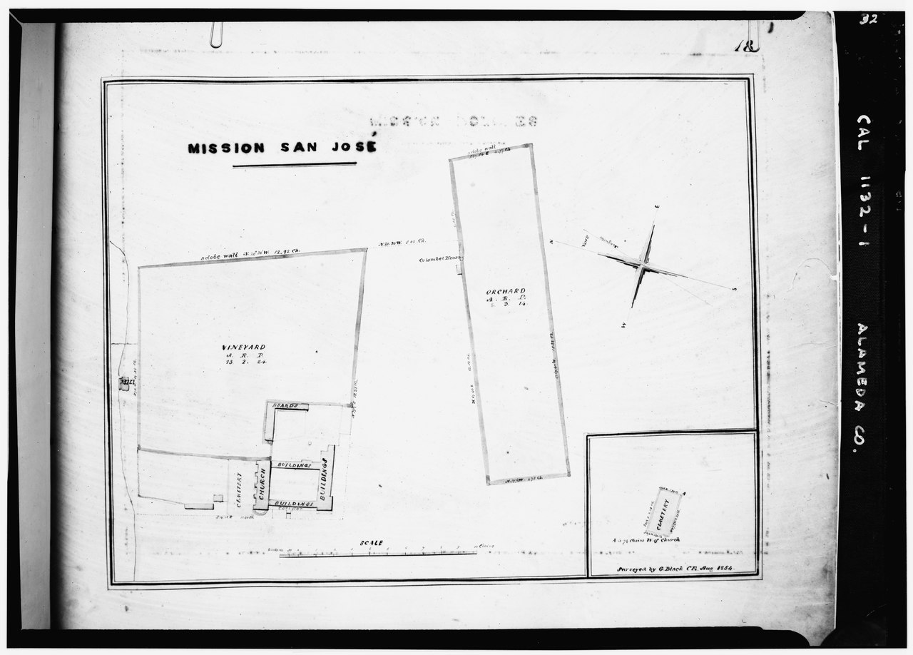
English: Site plan of Mission San José de Guadalupe compound — in present day Fremont, Alameda County, California. * 1960 drawing: HABS—Historic American Buildings Survey of California. |
|||
| Depicted place | California; Alameda County; Fremont | |||
| Date | 1938 | |||
| Dimensions | 5 x 7 in. | |||
| Current location |
Library of Congress Prints and Photographs Division Washington, D.C. 20540 USA http://hdl.loc.gov/loc.pnp/pp.print |
|||
| Accession number |
HABS CAL,1-FREMO,1-21 |
|||
| Credit line |
|
|||
| Source | https://www.loc.gov/pictures/item/ca0006.photos.010798p | |||
| Permission (Reusing this file) |
|
|||

| Camera location | | View this and other nearby images on: OpenStreetMap |
|---|
File history
Click on a date/time to view the file as it appeared at that time.
| Date/Time | Thumbnail | Dimensions | User | Comment | |
|---|---|---|---|---|---|
| current | 01:44, 2 July 2014 |  | 5,000 × 3,584 (17.09 MB) | Fæ (talk | contribs) | GWToolset: Creating mediafile for Fæ. HABS 1 July 2014 (201:300) |
You cannot overwrite this file.
File usage on Commons
The following page uses this file: