File:Helsinki tram map 2020.png
Jump to navigation
Jump to search

Size of this preview: 518 × 600 pixels. Other resolutions: 207 × 240 pixels | 415 × 480 pixels | 664 × 768 pixels | 885 × 1,024 pixels | 1,722 × 1,993 pixels.
Original file (1,722 × 1,993 pixels, file size: 2.92 MB, MIME type: image/png)
Captions
Captions
Add a one-line explanation of what this file represents
Summary
[edit]
| Description |
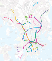
English: Map of the Helsinki tram network as of 14 December 2020.
Suomi: Helsingin raitiotieverkon kartta 14. joulukuuta 2020 lähtien.
Svenska: Kartan över Helsingfors spårvägslinjer från 14 december 2020. |
| Date | |
| Source | Own work. Basemap by Maanmittauslaitos (CC BY 4.0). |
| Author | Matiasl |
Licensing
[edit]
This file is licensed under the Creative Commons Attribution-Share Alike 4.0 International license.
- You are free:
- to share – to copy, distribute and transmit the work
- to remix – to adapt the work
- Under the following conditions:
- attribution – You must give appropriate credit, provide a link to the license, and indicate if changes were made. You may do so in any reasonable manner, but not in any way that suggests the licensor endorses you or your use.
- share alike – If you remix, transform, or build upon the material, you must distribute your contributions under the same or compatible license as the original.
File history
Click on a date/time to view the file as it appeared at that time.
| Date/Time | Thumbnail | Dimensions | User | Comment | |
|---|---|---|---|---|---|
| current | 13:39, 4 February 2022 | | 1,722 × 1,993 (2.92 MB) | Matiasl (talk | contribs) | Reverted to version as of 13:37, 4 February 2022 (UTC) |
| 13:38, 4 February 2022 |  | 1,722 × 1,994 (3.23 MB) | Matiasl (talk | contribs) | Reverted to version as of 17:58, 7 May 2021 (UTC) | |
| 13:37, 4 February 2022 |  | 1,722 × 1,993 (2.92 MB) | Matiasl (talk | contribs) | October 2021 changes to the network | |
| 17:58, 7 May 2021 |  | 1,722 × 1,994 (3.23 MB) | Matiasl (talk | contribs) | May 2021 changes to the network | |
| 00:16, 14 December 2020 |  | 1,700 × 1,998 (2.89 MB) | Matiasl (talk | contribs) | Uploaded a work by Matiasl from Own work. Basemap by Maanmittauslaitos (CC BY 4.0). with UploadWizard |
You cannot overwrite this file.
File usage on Commons
The following 10 pages use this file:
- User:Apalsola/recent uploads/Rail transport in Finland/2020 December 11-20
- User:Apalsola/recent uploads/Rail transport in Finland/2021 May 1-10
- User:Apalsola/recent uploads/Rail transport in Finland/2022 February 1-9
- User:Chumwa/OgreBot/Public transport information/2020 December 11-20
- User:Chumwa/OgreBot/Public transport information/2021 May 1-10
- User:Chumwa/OgreBot/Public transport information/2022 February 1-9
- User:Chumwa/OgreBot/Transport Maps/2020 December 11-20
- User:Chumwa/OgreBot/Transport Maps/2021 May 1-10
- User:Chumwa/OgreBot/Transport Maps/2022 February 1-9
- Category:Tram transport in Helsinki
File usage on other wikis
The following other wikis use this file:
- Usage on ar.wikipedia.org
- Usage on de.wikipedia.org
- Usage on en.wikivoyage.org
- Usage on fi.wikipedia.org
- Usage on fr.wikipedia.org
- Usage on hu.wikipedia.org
- Usage on nl.wikipedia.org
- Usage on pl.wikipedia.org
- Usage on ru.wikipedia.org
- Usage on sv.wikipedia.org
- Usage on uk.wikipedia.org
- Usage on www.wikidata.org