File:Heinrich Kiepert, Plan von Jerusalem (FL6878585 2370022).jpg
Jump to navigation
Jump to search

Size of this preview: 478 × 599 pixels. Other resolutions: 191 × 240 pixels | 383 × 480 pixels | 613 × 768 pixels | 817 × 1,024 pixels | 2,220 × 2,783 pixels.
Original file (2,220 × 2,783 pixels, file size: 3.02 MB, MIME type: image/jpeg)
Captions
Captions
Add a one-line explanation of what this file represents
Summary
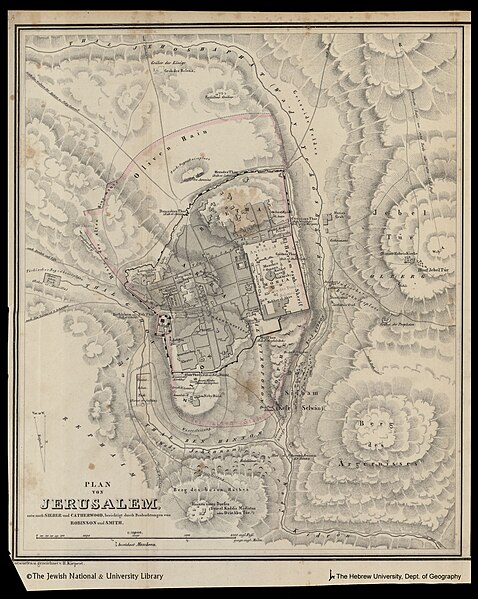
[edit]| Heinrich Kiepert: Plan von Jerusalem
( |
||||||||||||||||||||||||
|---|---|---|---|---|---|---|---|---|---|---|---|---|---|---|---|---|---|---|---|---|---|---|---|---|
| Artist |
| |||||||||||||||||||||||
| Contributors | Smith, Eli, 1801-1857 Robinson, Edward, 1794-1863 Mahlmann, Heinrich | |||||||||||||||||||||||
| Title |
Plan von Jerusalem |
|||||||||||||||||||||||
| Publisher |
Verlag der Buchhandlung des Waisenhauses |
|||||||||||||||||||||||
| Description |
Plan von Jerusalem. entw. nach Sieber und Catherwood, berichtigt durch Beobaehtungen von Robinson und Smith . Entworfen u. gezeichnet von H. Kiepert. In Stein gest: von H.Mahlmann. |
|||||||||||||||||||||||
| Language | German | |||||||||||||||||||||||
| Publication date | 1842 | |||||||||||||||||||||||
| Dimensions | height: 318 mm (12.51 in); width: 267 mm (10.51 in) | |||||||||||||||||||||||
| Collection |
|
|||||||||||||||||||||||
| Current location |
|
|||||||||||||||||||||||
| Place of publication | Halle (Saale) | |||||||||||||||||||||||
| search Merhav catalog | Halle (Saale) | |||||||||||||||||||||||
| Notes | From: Robinson, Edward. Palästina und die südlich angrenzenden Länder. Halle, 1841-2, vol.3, part II, at the end. 34 V 1426; H. Mahlmann; On the same sheet map: Umgebungen von Jerusalem - pal 1252A. | |||||||||||||||||||||||
| scale | 1:10,000 cm | |||||||||||||||||||||||
| IE PID | IE6878583 | |||||||||||||||||||||||
| Rosetta filename | FL6878585 | |||||||||||||||||||||||
| NNL item ID (P3959) | 990023700220205171 | |||||||||||||||||||||||
| search Merhav catalog | German, Heinrich Kiepert | |||||||||||||||||||||||
| search Merhav catalog | Verlag der Buchhandlung des Waisenhauses | |||||||||||||||||||||||
| Source/Photographer |
|
|||||||||||||||||||||||
| Other versions | ||||||||||||||||||||||||
| Jpg / Tif version |
|
|||||||||||||||||||||||
Loescher_%26_btv1b8453164n_(cropped).jpg)

.jpg)

.jpg&action=edit§ion=1)
Licensing
[edit].jpg&action=edit§ion=2)
The copyright situation of this work is theoretically uncertain, because in the country of origin copyright lasts 70 years after the death of the author, and the date of the author's death is unknown. However, the date of creation of the work was over 120 years ago, and it is thus a reasonable assumption that the copyright has expired (see here for the community discussion). Do not use this template if the date of death of the author is known.
| |
| This file has been identified as being free of known restrictions under copyright law, including all related and neighboring rights. | |
File history
Click on a date/time to view the file as it appeared at that time.
| Date/Time | Thumbnail | Dimensions | User | Comment | |
|---|---|---|---|---|---|
| current | 03:56, 30 July 2023 | | 2,220 × 2,783 (3.02 MB) | Geagea (talk | contribs) | pattypan 22.03 |
You cannot overwrite this file.
File usage on Commons
The following page uses this file:
.jpg&oldid=788121415)