File:HavensRotterdam.png
Jump to navigation
Jump to search
Size of this preview: 800 × 278 pixels. Other resolutions: 320 × 111 pixels | 1,338 × 465 pixels.
Original file (1,338 × 465 pixels, file size: 56 KB, MIME type: image/png)
Captions
Captions
Add a one-line explanation of what this file represents
Summary
[edit]
| Description |
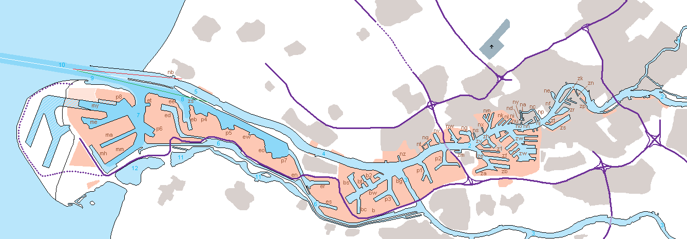
English: The harbour of Rotterdam with all the waters and harbours numbered. Details:
Nederlands: De haven van Rotterdam met alle wateren en havens genummerd, details:
|
| Date | |
| Source | Own work |
| Author | Romaine |
| Code | Name of the harbour |
|---|---|
| b | Botlek |
| b2 | 2e Werkhaven |
| bc | Chemiehaven |
| bg | Geulhaven |
| bs | Sint-Laurenshaven |
| bt | Torontohaven |
| bw | Welplaathaven |
| e | Europoort |
| eb | Beneluxhaven |
| ed | Dintelhaven |
| ee | Elbehaven |
| en | Neckarhaven |
| eo | Donauhaven |
| er | Brittanniëhaven |
| es | Seinehaven |
| et | Tennesseehaven |
| ew | Wezerhaven |
| m | Maasvlakte |
| ma | Amazonehaven |
| me | Europahaven |
| mh | Hartelhaven |
| mm | Mississippihaven |
| my | Yangtzehaven |
| na | Achterhaven |
| nb | Berghaven |
| nc | Coolhaven |
| nd | Middenkous |
| ne | Leuvehaven |
| nf | Veerhaven |
| ng | Wilhelminahaven |
| nh | Schiehaven |
| ni | IJselhaven |
| nj | St. Jobshaven |
| nk | Kettehaven |
| nk | Koningshaven |
| nl | Lekhaven |
| nm | Merwehaven |
| no | Schiemond |
| np | Parkhaven |
| nq | Koningin Wilhelminahaven |
| ns | Spuihaven |
| nt | Buitenhaven |
| nu | Koushaven |
| nv | Vulcaanhaven |
| nw | Wiltonhaven |
| nx | Voorhaven |
| ny | Voorhaven |
| nz | Zevenmanshaven |
| p1 | 1e Petroleumhaven |
| p2 | 2e Petroleumhaven |
| p3 | 3e Petroleumhaven |
| p4 | 4e Peutroleumhaven |
| p5 | 5e Peutroleumhaven |
| p6 | 6e Petroleumhaven |
| p7 | 7e Peutroleumhaven |
| p8 | 8e Petroleumhaven |
| z1 | 1e Eemhaven |
| za | Prins Willem Alexanderhaven |
| zb | Prinses Beatrixhaven |
| ze | Eemhaven |
| zf | Prins Johan Frisohaven |
| zh | Heysehaven |
| zm | Madroelhaven |
| zn | Nassauhaven |
| zp | Persoonshaven |
| zr | Rijnhaven |
| zs | Maashaven |
| zs | Scheurhaven |
| zt | 2e Katendr. h. |
| zv | Werkhaven |
| zw | Waalhaven |
| Number | Name water |
|---|---|
| 1 | Hollandsche IJssel |
| 2 | Nieuwe Maas |
| 3 | Oude Maas |
| 4 | Scheur |
| 5 | Nieuwe Waterweg |
| 6 | Hartelkanaal |
| 7 | Beerkanaal |
| 8 | Calandkanaal |
| 9 | Maasmond |
| 10 | Maasgeul (goes over in the Eurogeul) |
| 11 | Brielse Meer |
| 12 | Oostvoornse Meer |
Licensing
[edit]
| This file is made available under the Creative Commons CC0 1.0 Universal Public Domain Dedication. | |
| The person who associated a work with this deed has dedicated the work to the public domain by waiving all of their rights to the work worldwide under copyright law, including all related and neighboring rights, to the extent allowed by law. You can copy, modify, distribute and perform the work, even for commercial purposes, all without asking permission.
|
File history
Click on a date/time to view the file as it appeared at that time.
| Date/Time | Thumbnail | Dimensions | User | Comment | |
|---|---|---|---|---|---|
| current | 19:04, 18 September 2009 | 1,338 × 465 (56 KB) | Romaine (talk | contribs) | {{Information |Description={{en|1=The harbour of Rotterdam with all the waters and harbours numbered. Details: *the Maasgeul (Eurogeul) and other deeper water in darker blue *3 leading lights: white, red and green, for ships to ent |
You cannot overwrite this file.
File usage on Commons
The following 4 pages use this file:
.png)
.png)
File usage on other wikis
The following other wikis use this file:
- Usage on de.wikipedia.org
- Usage on fr.wikipedia.org
- Usage on uk.wikipedia.org