File:Guide to the Rutgert Van Brunt survey map of Brooklyn lot at ferry 1974.164.pdf
Jump to navigation
Jump to search

Size of this JPG preview of this PDF file: 374 × 599 pixels. Other resolutions: 150 × 240 pixels | 300 × 480 pixels | 480 × 768 pixels | 1,239 × 1,983 pixels.
Original file (1,239 × 1,983 pixels, file size: 1.5 MB, MIME type: application/pdf)
Captions
Captions
Guide to the Rutgert Van Brunt survey map of Brooklyn lot at ferry (call phrase: 1974.164)
Summary
[edit]| Description |
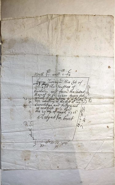
English: A hand drawn map of a lot at the ferry in Brooklyn, New York, surveyed by Rutgert Van Brunt for the town trustees, March 27, 1716. It is not known which Rutgert Van Brunt created the map. The map had been owned by historian and genealogist Teunis G. Bergen (1806-1881).
Source: Brooklyn Historical Society 1974.164 |
| Date | |
| Source | Brooklyn Historical Society 1974.164 |
| Creator |
Rutgert Van Brunt |
| Georeferencing | If inappropriate please set warp_status = skip to hide. |
Licensing
[edit]This work is in the public domain in the United States because it was published (or registered with the U.S. Copyright Office) before January 1, 1929.
Public domain works must be out of copyright in both the United States and in the source country of the work in order to be hosted on the Commons. If the work is not a U.S. work, the file must have an additional copyright tag indicating the copyright status in the source country.
Note: This tag should not be used for sound recordings. |
File history
Click on a date/time to view the file as it appeared at that time.
| Date/Time | Thumbnail | Dimensions | User | Comment | |
|---|---|---|---|---|---|
| current | 11:15, 22 February 2023 |  | 1,239 × 1,983 (1.5 MB) | DutchTreat (talk | contribs) | Uploaded a work by Rutgert Van Brunt from Brooklyn Historical Society [http://dlib.nyu.edu/findingaids/html/bhs/arms_1974_164_van_brunt_map/arms_1974_164_van_brunt_map.html 1974.164] with UploadWizard |
You cannot overwrite this file.
File usage on Commons
The following page uses this file: