File:GlacierNP L7 20010701.jpg
Jump to navigation
Jump to search
No higher resolution available.
GlacierNP_L7_20010701.jpg (540 × 540 pixels, file size: 124 KB, MIME type: image/jpeg)
Captions
Captions
Add a one-line explanation of what this file represents
Summary
[edit]
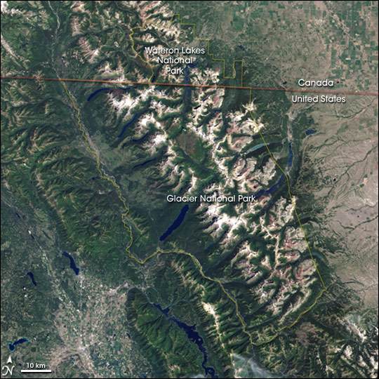
| Description | w:Landsat 7 natural-color image of Glacier National Park (USA) and Waterton Lakes National Park. |
| Date | |
| Source | http://earthobservatory.nasa.gov/Newsroom/NewImages/images.php3?img_id=17224 |
| Author | Jesse Allen, NASA Earth Observatory, using data obtained courtesy of the University of Maryland’s Global Land Cover Facility. |
| Permission (Reusing this file) |
US government, public domain |
| Other versions | Larger, unannotated version available from source URL. |
Licensing
[edit]
| This file is in the public domain in the United States because it was solely created by NASA. NASA copyright policy states that "NASA material is not protected by copyright unless noted". (See Template:PD-USGov, NASA copyright policy page or JPL Image Use Policy.) | ||
 |
Warnings:
|
File history
Click on a date/time to view the file as it appeared at that time.
| Date/Time | Thumbnail | Dimensions | User | Comment | |
|---|---|---|---|---|---|
| current | 20:47, 27 April 2006 | | 540 × 540 (124 KB) | Holly Cheng (talk | contribs) | {{Information | Description=w:Landsat 7 natural-color image of Glacier National Park (USA) and Waterton Lakes National Park. | Source=http://earthobservatory.nasa.gov/Newsroom/NewImages/images.php3?img_id |
You cannot overwrite this file.
File usage on Commons
The following 2 pages use this file:
File usage on other wikis
The following other wikis use this file:
- Usage on ar.wikipedia.org
- Usage on ca.wikipedia.org
- Usage on ceb.wikipedia.org
- Usage on ckb.wikipedia.org
- Usage on cs.wikipedia.org
- Usage on de.wikipedia.org
- Usage on de.wikivoyage.org
- Usage on en.wikipedia.org
- Usage on eo.wikipedia.org
- Usage on es.wikipedia.org
- Usage on fi.wikipedia.org
- Usage on gl.wikipedia.org
- Usage on he.wikipedia.org
- Usage on he.wikivoyage.org
- Usage on hr.wikipedia.org
- Usage on hy.wikipedia.org
- Usage on id.wikipedia.org
- Usage on it.wikipedia.org
- Usage on ja.wikipedia.org
- Usage on ko.wikipedia.org
- Usage on ml.wikipedia.org
- Usage on mt.wikipedia.org
- Usage on my.wikipedia.org
- Usage on nl.wikipedia.org
- Usage on no.wikipedia.org
- Usage on pl.wikipedia.org
- Usage on ru.wikipedia.org
- Usage on sk.wikipedia.org
- Usage on te.wikipedia.org
- Usage on tr.wikipedia.org
- Usage on uk.wikipedia.org
- Usage on vi.wikipedia.org
- Usage on www.wikidata.org
- Usage on zh.wikipedia.org
View more global usage of this file.
Metadata
Categories:
- Landsat images of Canada
- Satellite pictures of Washington (state)
- Landsat images of the United States
- Aerial photographs of Glacier National Park
- Waterton Glacier International Peace Park
- Satellite pictures of glaciers
- 2001 in British Columbia
- July 2001 in Washington (state)
- Annotated satellite pictures of North America