File:Geographica restituta per globi trientes - Norman B. Leventhal Map Center at the BPL.jpg
Jump to navigation
Jump to search

Size of this preview: 800 × 547 pixels. Other resolutions: 320 × 219 pixels | 640 × 437 pixels | 1,024 × 700 pixels | 1,200 × 820 pixels.
Original file (1,200 × 820 pixels, file size: 421 KB, MIME type: image/jpeg)
Captions
Captions
Add a one-line explanation of what this file represents
Summary
[edit]
| Description |
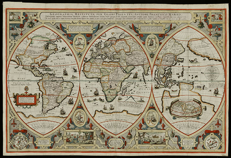
Zoom into this map at maps.bpl.org. Author: Verhaer, Franciscus. Publisher: [s.n.] Date: 1618. Scale: Scale not given. Call Number: G3200 1618.V4 Displaying the known world of the early 17th century as a triptych, with the map divided into three segments or gores, was very uncommon during the Golden Age of Dutch cartography. However, such a format was commonly used in altarpieces and would have been familiar to a Christian audience. Dividing the world into three parts was also reminiscent of the world diagrams drawn in the Medieval Christian tradition, especially Heinrich Bèunting's cloverleaf map. In the latter diagram, each of the three leaves (or gores) represented one of the known continents -- Europe, Africa, and Asia. In Verhaer's map, only the central section focused on this Old World view of the lands bordering the Mediterranean Sea -- Europe, Africa, and western Asia. Interestingly, the central focal point of this segment was still the eastern Mediterranean and by implication, Jerusalem reflecting the influence of the Medieval Christian world diagrams. The left section displayed the European discoveries to the west (Novus Occidens)-- the Atlantic Ocean and the Americas. Meanwhile, the right sphere depicts the European discoveries to the east (Novus Oriens) -- the Far East, the East Indies, and the Pacific Ocean. While this three-part projection reduced the amount of distortion for the respective geographic areas, it was also a logical presentation of classical and medieval geographical tradition in the context of the new geographical knowledge gleaned from Europeans' 15th- and 16th-century explorations. |
| Date | |
| Source | Geographica restituta per globi trientes |
| Author | http://maps.bpl.org |
Licensing
[edit]
This file is licensed under the Creative Commons Attribution 2.0 Generic license.
- You are free:
- to share – to copy, distribute and transmit the work
- to remix – to adapt the work
- Under the following conditions:
- attribution – You must give appropriate credit, provide a link to the license, and indicate if changes were made. You may do so in any reasonable manner, but not in any way that suggests the licensor endorses you or your use.
| This image was originally posted to Flickr by Norman B. Leventhal Map Center at the BPL at https://www.flickr.com/photos/24528911@N05/2709981627. It was reviewed on 2 July 2012 by FlickreviewR and was confirmed to be licensed under the terms of the cc-by-2.0. |
File history
Click on a date/time to view the file as it appeared at that time.
| Date/Time | Thumbnail | Dimensions | User | Comment | |
|---|---|---|---|---|---|
| current | 01:41, 2 July 2012 | | 1,200 × 820 (421 KB) | Dzlinker (talk | contribs) | == {{int:filedesc}} == {{Information |Description=Zoom into [http://maps.bpl.org/id/M8797/ this map] at [http://maps.bpl.org maps.bpl.org]. '''Author:''' Verhaer, Franciscus. '''Publisher:''' [s.n.] '''Date:''' 1618. '''Scale:''' Scale not given. '''Ca... |
You cannot overwrite this file.
File usage on Commons
There are no pages that use this file.
File usage on other wikis
The following other wikis use this file:
- Usage on en.wikipedia.org