File:Generalʹnai︠a︡ Karta I︠A︡roslavskoĭ Gubernii Sʺ pokazaniemʺ pochtovykhʺ i bolʹshikhʺ proi︠e︡zzhikhʺ dorogʺ, stant︠s︡iĭ i razstoi︠a︡nii︠a︡ mezhdu onymi verstʺ. LOC 2018688665.tif
Jump to navigation
Jump to search

Size of this JPG preview of this TIF file: 710 × 600 pixels. Other resolutions: 284 × 240 pixels | 568 × 480 pixels | 909 × 768 pixels | 1,212 × 1,024 pixels | 2,425 × 2,048 pixels | 5,744 × 4,852 pixels.
Original file (5,744 × 4,852 pixels, file size: 79.74 MB, MIME type: image/tiff)
Captions
Captions
Add a one-line explanation of what this file represents
Summary
[edit]| Description |
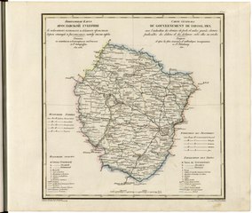
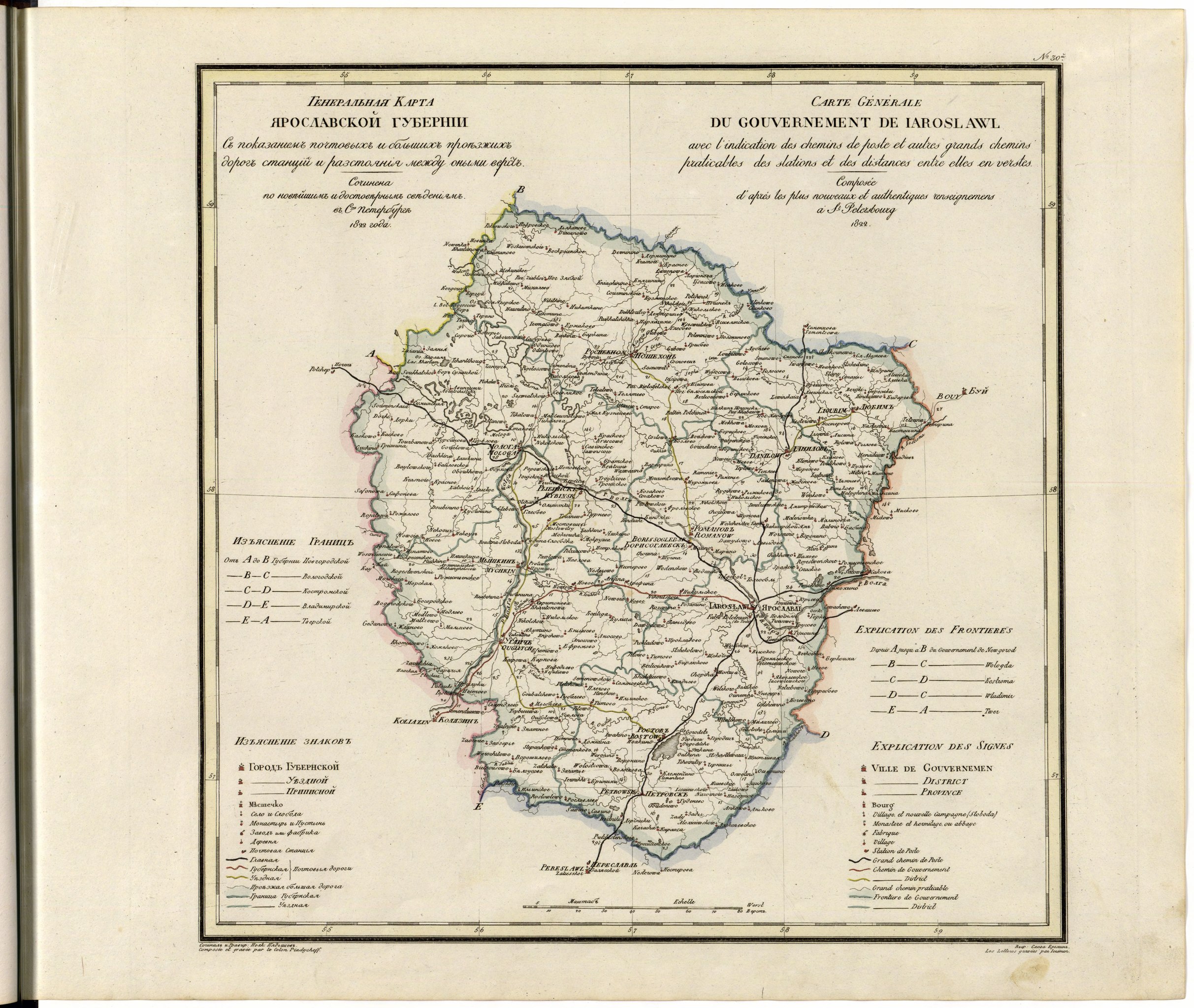
English: This 1822 map of Yaroslavl Provinceis from a larger work,Geograficheskii atlas Rossiiskoi imperii, tsarstva Pol'skogo i velikogo kniazhestva Finliandskogo(Geographical atlas of the Russian Empire, the Kingdom of Poland, and the Grand Duchy of Finland), containing 60 maps of the Russian Empire. Compiled and engraved by Colonel V.P. Piadyshev, it reflects the detailed mapping carried out by Russian military cartographers in the first quarter of the 19th century. The map shows population centers (six gradations by size), postal stations, roads (four types), provincial and district borders,monasteries, and factories. Distances are shown in versts, a Russian measure, now no longer used, equal to 1.07 kilometers.Legends and place-names are in Russian and French. Founded in 1010 by Yaroslav the Wise, Yaroslavl became a key municipality in Russian history. Archeological evidence shows that it was an early Scandinavian (Rus') settlement from the Viking era, evolving later into a Slavic trading center on the Volga River. Yaroslavl withstood numerous attacks by the Golden Horde in the 13th and 14th centuries. It continued, nevertheless, to emerge as an economic and political center along the main route from Moscow to Arkhangelsk on the White Sea (and from there by ship to Western Europe). Muscovy ultimately absorbed Yaroslavl in the mid-15th century, after which it became a northern outpost involved in the subsequent upheavals of the Russian state, such as the Time of Troubles from 1598 to 1613 (the interregnum between the fall of the Rurik dynasty and the establishment of the Romanovs). Yaroslavl Province rose to further economic and administrative prominence under Catherine the Great in the late 18th century and absorbed neighboring ancient Russian cities, such as Rostov Veliky (Rostov the Great). World Digital Library. |
||
| Title | Generalʹnai︠a︡ Karta I︠A︡roslavskoĭ Gubernii Sʺ pokazaniemʺ pochtovykhʺ i bolʹshikhʺ proi︠e︡zzhikhʺ dorogʺ, stant︠s︡iĭ i razstoi︠a︡nii︠a︡ mezhdu onymi verstʺ. | ||
| Shelf ID | http://lccn.loc.gov/2018688665 | ||
| Date | |||
| Source | https://www.loc.gov/item/2018688665/ | ||
| Author | Pi︠A︡Dyshev, Vasiliĭ Petrovich; Ieremin; Russia. General Staff. Military Topographical Depot | ||
| Permission (Reusing this file) |
|
||
| Other versions |
|
||
| Location | Russian Federation · Yaroslavl Oblast | ||
| Part of | Geographical Atlas Of The Russian Empire, The Kingdom Of Poland, And The Grand Duchy Of Finland · Catalog · National Library Of Russia · Meeting Of Frontiers | ||
| Subject | Russian Federation · Maps · Atlases · Yaroslavl Oblast · Siberia |


Licensing
[edit]|
This is a faithful photographic reproduction of a two-dimensional, public domain work of art. The work of art itself is in the public domain for the following reason:
The official position taken by the Wikimedia Foundation is that "faithful reproductions of two-dimensional public domain works of art are public domain".
This photographic reproduction is therefore also considered to be in the public domain in the United States. In other jurisdictions, re-use of this content may be restricted; see Reuse of PD-Art photographs for details. | ||||
File history
Click on a date/time to view the file as it appeared at that time.
| Date/Time | Thumbnail | Dimensions | User | Comment | |
|---|---|---|---|---|---|
| current | 11:34, 27 January 2020 |  | 5,744 × 4,852 (79.74 MB) | Fæ (talk | contribs) | LOC Maps https://www.loc.gov/item/2018688665/ #16820 |
You cannot overwrite this file.
File usage on Commons
The following page uses this file: