File:Generalʹnai︠a︡ Karta Eniseĭskoĭ Gubernii Sʺ pokazaniemʺ pochtovykhʺ i bolʹshikhʺ proi︠e︡zzhikhʺ dorogʺ, stant︠s︡iĭ i razstoi︠a︡nii︠a︡ mezhdu onymi verstʺ. LOC 2018688688.tif
Jump to navigation
Jump to search

Size of this JPG preview of this TIF file: 338 × 599 pixels. Other resolutions: 135 × 240 pixels | 270 × 480 pixels | 433 × 768 pixels | 577 × 1,024 pixels | 1,155 × 2,048 pixels | 5,311 × 9,419 pixels.
Original file (5,311 × 9,419 pixels, file size: 143.12 MB, MIME type: image/tiff)
Captions
Captions
Add a one-line explanation of what this file represents
Summary
[edit]| Description |
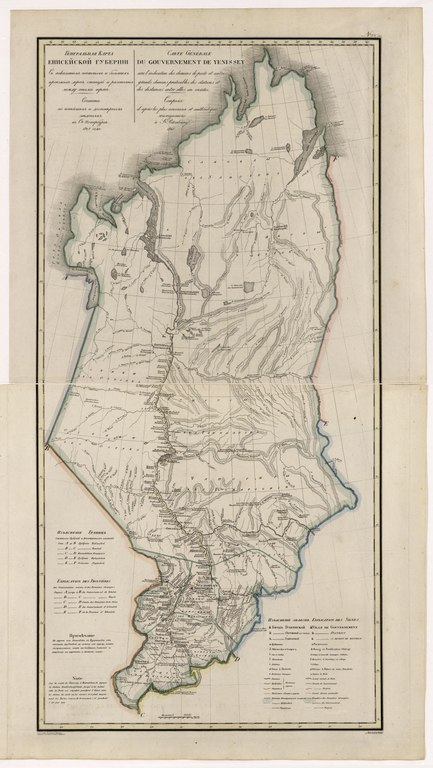
English: This 1825 map of Yenisei Provinceis from a larger work,Geograficheskii atlas Rossiiskoi imperii, tsarstva Pol'skogo i velikogo kniazhestva Finliandskogo(Geographical atlas of the Russian Empire, the Kingdom of Poland, and the Grand Duchy of Finland), containing 60 maps of the Russian Empire. Compiled and engraved by Colonel V.P. Piadyshev, it reflects the detailed mapping carried out by Russian military cartographers in the first quarter of the 19th century. The map shows population centers (six gradations by size), postal stations, roads (four types),borders with foreign lands, provincial and district borders,forts, monasteries, factories, and mines. Distances are shown in versts, a Russian measure, now no longer used, equal to 1.07 kilometers.Legends and place-names are in Russian and French. The Russians reached the Yenisei region in the early 17th century, after following the east-west tributaries of the large Siberian rivers that flowed north to the Arctic Ocean. The Yenisei Province in the tsarist era was long and narrow, on a north-south axis, as it traced the basin of the Yenisei River, stretching from near the southern border of Siberia to the Arctic. Fur-trading was the mainstay of the local economy.In 1822 Yenisei Province was formed, which was part of the Governorate-General of Eastern Siberia. World Digital Library. |
||
| Title | Generalʹnai︠a︡ Karta Eniseĭskoĭ Gubernii Sʺ pokazaniemʺ pochtovykhʺ i bolʹshikhʺ proi︠e︡zzhikhʺ dorogʺ, stant︠s︡iĭ i razstoi︠a︡nii︠a︡ mezhdu onymi verstʺ. | ||
| Shelf ID | http://lccn.loc.gov/2018688688 | ||
| Date | |||
| Source | https://www.loc.gov/item/2018688688/ | ||
| Author | Pi︠A︡Dyshev, Vasiliĭ Petrovich; Ieremin; Russia. General Staff. Military Topographical Depot | ||
| Permission (Reusing this file) |
|
||
| Other versions |
|
||
| Location | Russian Federation · Krasnoyarsk Krai | ||
| Part of | Geographical Atlas Of The Russian Empire, The Kingdom Of Poland, And The Grand Duchy Of Finland · Catalog · National Library Of Russia · Meeting Of Frontiers | ||
| Subject | Russian Federation · Maps · Atlases · Siberia · Krasnoyarsk Krai |

Licensing
[edit]|
This is a faithful photographic reproduction of a two-dimensional, public domain work of art. The work of art itself is in the public domain for the following reason:
The official position taken by the Wikimedia Foundation is that "faithful reproductions of two-dimensional public domain works of art are public domain".
This photographic reproduction is therefore also considered to be in the public domain in the United States. In other jurisdictions, re-use of this content may be restricted; see Reuse of PD-Art photographs for details. | ||||
File history
Click on a date/time to view the file as it appeared at that time.
| Date/Time | Thumbnail | Dimensions | User | Comment | |
|---|---|---|---|---|---|
| current | 16:50, 19 January 2020 |  | 5,311 × 9,419 (143.12 MB) | Fæ (talk | contribs) | LOC Maps https://www.loc.gov/item/2018688688/ #9043 |
You cannot overwrite this file.
File usage on Commons
There are no pages that use this file.