File:Generalʹnai︠a︡ Karta Bessarabskoĭ Oblasti sʺ pokazaniemʺ pochtovykhʺ i bolʹshikhʺ proi︠e︡zzhikhʺ dorogʺ, stant︠s︡iĭ i razstoi︠a︡nii︠a︡ mezhdu onymi verstʺ. LOC 2018688650.jpg
Jump to navigation
Jump to search

Size of this preview: 710 × 599 pixels. Other resolutions: 284 × 240 pixels | 569 × 480 pixels | 910 × 768 pixels | 1,213 × 1,024 pixels | 2,427 × 2,048 pixels | 5,744 × 4,848 pixels.
Original file (5,744 × 4,848 pixels, file size: 3.35 MB, MIME type: image/jpeg)
Captions
Captions
Add a one-line explanation of what this file represents
Summary
[edit]| Description |
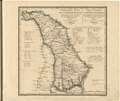
English: This 1821 map of Bessarabia is from a larger work, Geograficheskii atlas Rossiiskoi imperii, tsarstva Pol'skogo i velikogo kniazhestva Finliandskogo (Geographical atlas of the Russian Empire, the Kingdom of Poland, and the Grand Duchy of Finland), containing 60 maps of the Russian Empire. Compiled and engraved by Colonel V.P. Piadyshev, it reflects the detailed mapping carried out by Russian military cartographers in the first quarter of the 19th century. The map shows population centers (five gradations by size), monasteries, customs houses, postal stations, roads (three types), state and provincial borders, and colonies of German and Polish settlers. Distances are shown in versts, a Russian measure, now no longer used, equal to 1.07 kilometers. Legends and place-names are in Russian and French. The province of Bessarabia, conquered by Russia in the Russo-Turkish War of 1806-12, roughly corresponds to the territory of present-day Moldovaand some of the western part of Ukraine. Bessarabia was carved from the eastern portions of the Principality of Moldavia, a former vassal state of the Ottoman Empire. World Digital Library. |
||
| Title | Generalʹnai︠a︡ Karta Bessarabskoĭ Oblasti sʺ pokazaniemʺ pochtovykhʺ i bolʹshikhʺ proi︠e︡zzhikhʺ dorogʺ, stant︠s︡iĭ i razstoi︠a︡nii︠a︡ mezhdu onymi verstʺ. | ||
| Shelf ID | http://lccn.loc.gov/2018688650 | ||
| Date | |||
| Source | https://www.loc.gov/item/2018688650/ | ||
| Author | Pi︠A︡Dyshev, Vasiliĭ Petrovich; Russia. General Staff. Military Topographical Depot; Iwanoff | ||
| Permission (Reusing this file) |
|
||
| Other versions |
|
||
| Location | Russian Federation · Ukraine · Odes'Ka Oblast · Moldova | ||
| Part of | Geographical Atlas Of The Russian Empire, The Kingdom Of Poland, And The Grand Duchy Of Finland · Catalog · National Library Of Russia · Meeting Of Frontiers | ||
| Subject | Ukraine · Atlases · Odes'Ka Oblast · Moldova · Maps · Russian Federation · Siberia |

Licensing
[edit]
|
This is a faithful photographic reproduction of a two-dimensional, public domain work of art. The work of art itself is in the public domain for the following reason:
The official position taken by the Wikimedia Foundation is that "faithful reproductions of two-dimensional public domain works of art are public domain".
This photographic reproduction is therefore also considered to be in the public domain in the United States. In other jurisdictions, re-use of this content may be restricted; see Reuse of PD-Art photographs for details. | ||||
File history
Click on a date/time to view the file as it appeared at that time.
| Date/Time | Thumbnail | Dimensions | User | Comment | |
|---|---|---|---|---|---|
| current | 04:12, 22 January 2020 | | 5,744 × 4,848 (3.35 MB) | Fæ (talk | contribs) | LOC Maps https://www.loc.gov/item/2018688650/ #31250 |
You cannot overwrite this file.
File usage on Commons
The following page uses this file: