File:Gegend der Staedte Berlin und Potsdam 1768.jpg

Original file (4,594 × 2,863 pixels, file size: 3.17 MB, MIME type: image/jpeg)
Captions
Captions
| Description |
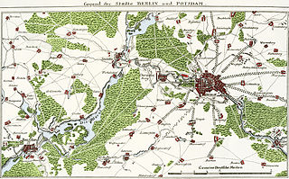
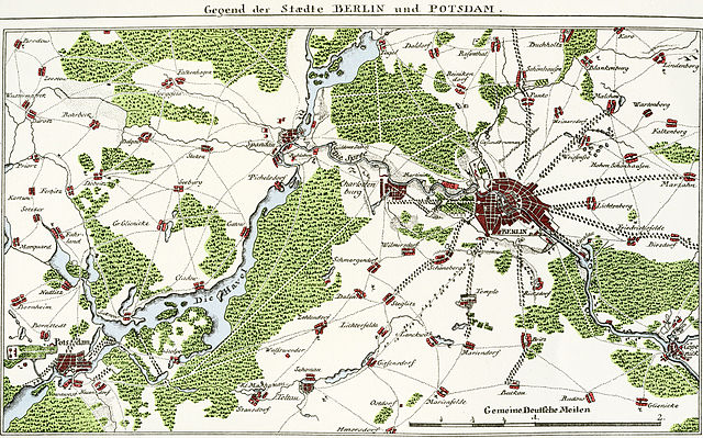
Gegend der Staedte BERLIN und POTSDAM.
Der Titel steht 1-zeilig über dem Plan. Rechts unten ein Maßstab über 2 "Gemeine Deutsche Meilen". Die genaue Datierung ist schwierig - nach A.F. Büschings Vollständige Topographie der Mark Brandenburg wurde der Plan im Berlinschen geneaologischen Calender für das Jahr 1771 veröffentlicht und geht auf Johann Christoph Rhode zurück. Der Plan ist ungenau und unvollständig. Bemerkung hierzu von Büsching: "Ich weiß nicht, ob man dieses Cärtchen nicht ganz vollkommen hat machen können, oder wollen?"[1] |
| Date | |
| Source | Staatsbibliothek Preußischer Kulturbesitz |
| Author | prob./vrmtl. Johann Christoph Rhode |
|
This work is in the public domain in its country of origin and other countries and areas where the copyright term is the author's life plus 100 years or fewer. | |
| This file has been identified as being free of known restrictions under copyright law, including all related and neighboring rights. | |
File history
Click on a date/time to view the file as it appeared at that time.
| Date/Time | Thumbnail | Dimensions | User | Comment | |
|---|---|---|---|---|---|
| current | 16:58, 10 June 2011 | | 4,594 × 2,863 (3.17 MB) | Alexrk2 (talk | contribs) | {{Information |Description='''Gegend der Staedte BERLIN und POTSDAM.''' * Format: 19,8 x 11,4 cm (nur der Plan) * Maßstab: ca 1:200.000 * Orientierung: Nord * orig. Kupferstich sw ;Beschreibung Der Titel steht 1-zeilig über dem Plan. Rechts unten ein Ma |
You cannot overwrite this file.
File usage on Commons
The following 2 pages use this file:
File usage on other wikis
The following other wikis use this file:
- Usage on de.wikipedia.org