File:GNIS map Branch vs. Run vs. Brook (4134813569).jpg

Original file (956 × 661 pixels, file size: 209 KB, MIME type: image/jpeg)
Captions
Captions
Summary
[edit].jpg&action=edit§ion=1)
| Description |
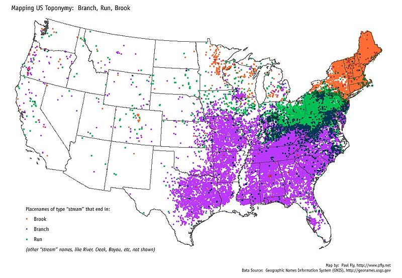
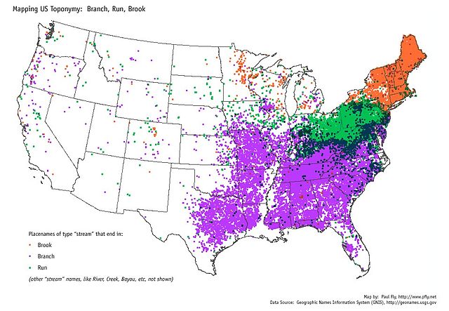
The USGS GNIS placename database was used to make this map. Any stream whose name ends in "Branch" gets a purple dot, any whose name ends in "Run" gets a green dot, and any whose name ends in "Brook" gets an orange dot. Stream names that end with other terms, like "River" or "Bayou" are not shown. This map shows a strong geographic pattern in the use of these stream terms. "Brook" occurs mostly in New England and New York. "Run" is confined mainly to Pennsylvania, Ohio, and northern West Virginia. "Branch" is common in the South, including Missouri. Indiana, Maryland and Appalachian Virginia use both "Branch" and "Run". New Jersey uses all three terms. There are other curious patterns, such as a cluster of "Branches" in southwest Wisconsin and "Brooks" in Minnesota. All three terms are rare in the West. Source data, USGS GNIS placename database and ESRI's state boundary data. Software, ESRI ArcGIS. |
| Date | |
| Source | Branch vs. Run vs. Brook |
| Author | pfly from Pugetopolis |
Licensing
[edit].jpg&action=edit§ion=2)
- You are free:
- to share – to copy, distribute and transmit the work
- to remix – to adapt the work
- Under the following conditions:
- attribution – You must give appropriate credit, provide a link to the license, and indicate if changes were made. You may do so in any reasonable manner, but not in any way that suggests the licensor endorses you or your use.
- share alike – If you remix, transform, or build upon the material, you must distribute your contributions under the same or compatible license as the original.
| This image was originally posted to Flickr by pfly at https://flickr.com/photos/24934185@N00/4134813569. It was reviewed on 29 October 2015 by FlickreviewR and was confirmed to be licensed under the terms of the cc-by-sa-2.0. |
File history
Click on a date/time to view the file as it appeared at that time.
| Date/Time | Thumbnail | Dimensions | User | Comment | |
|---|---|---|---|---|---|
| current | 09:23, 29 October 2015 | | 956 × 661 (209 KB) | Atlasowa (talk | contribs) | Transferred from Flickr via Flickr2Commons |
You cannot overwrite this file.
File usage on Commons
There are no pages that use this file.
File usage on other wikis
The following other wikis use this file:
- Usage on de.wikipedia.org
.jpg&oldid=885351090)