File:GENERAL VIEW OF COAL SHED, FACING EAST - U.S. Naval Air Station, Coal Shed, 499 South Avenue, Pensacola, Escambia County, FL HABS FLA,17-PENSA,67-1.tif

Original file (5,000 × 3,584 pixels, file size: 17.09 MB, MIME type: image/tiff)
Captions
Captions
Summary
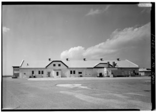
[edit]| GENERAL VIEW OF COAL SHED, FACING EAST - U.S. Naval Air Station, Coal Shed, 499 South Avenue, Pensacola, Escambia County, FL | ||||
|---|---|---|---|---|
| Photographer |
Related names:
|
|||
| Title |
GENERAL VIEW OF COAL SHED, FACING EAST - U.S. Naval Air Station, Coal Shed, 499 South Avenue, Pensacola, Escambia County, FL |
|||
| Depicted place | Florida; Escambia County; Pensacola | |||
| Date | Documentation compiled after 1933 | |||
| Dimensions | 5 x 7 in. | |||
| Current location |
Library of Congress Prints and Photographs Division Washington, D.C. 20540 USA http://hdl.loc.gov/loc.pnp/pp.print |
|||
| Accession number |
HABS FLA,17-PENSA,67-1 |
|||
| Credit line |
|
|||
| Notes |
Building No. 27 is an excellent example of the industrial buildings in use at the Pensacola Navy Yard and other military installations in the mid-nineteenth century. With its symmetrical form, engaged pilasters and brick cornice, it is similar in feeling to other utilitarian buildings at the heart of the old navy yard, including Building No. 1, Building No. 38, and Building No. 18. Building No. 27 is included within the Pensacola Naval Air Station Historic District.
|
|||
| References |
|
|||
| Source | https://www.loc.gov/pictures/item/fl0048.photos.052523p | |||
| Permission (Reusing this file) |
|
|||

| Camera location | | View this and other nearby images on: OpenStreetMap |
|---|
File history
Click on a date/time to view the file as it appeared at that time.
| Date/Time | Thumbnail | Dimensions | User | Comment | |
|---|---|---|---|---|---|
| current | 03:51, 11 July 2014 |  | 5,000 × 3,584 (17.09 MB) | Fæ (talk | contribs) | GWToolset: Creating mediafile for Fæ. HABS 09 July 2014 (801:1000) |
You cannot overwrite this file.
File usage on Commons
The following page uses this file: