File:GCRmap1903.JPG
Jump to navigation
Jump to search

Size of this preview: 450 × 600 pixels. Other resolutions: 180 × 240 pixels | 360 × 480 pixels | 576 × 768 pixels | 768 × 1,024 pixels | 1,536 × 2,048 pixels.
Original file (1,536 × 2,048 pixels, file size: 1,023 KB, MIME type: image/jpeg)
Captions
Captions
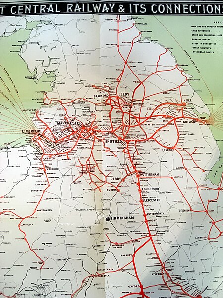
Map of Great Central Railway and connections as of 1903
Summary
[edit]
| Description |
English: The Great Central Railway network, 1903. Includes 'London Extension' and the 'Aylesbury Bypass' lines. Photograph of network map from the July 1903 GCR national timetable. Original document is out-of-copyright. |
| Date | |
| Source | Own work |
| Author | Jozg44 |
Licensing
[edit]
| I, the copyright holder of this work, release this work into the public domain. This applies worldwide. In some countries this may not be legally possible; if so: I grant anyone the right to use this work for any purpose, without any conditions, unless such conditions are required by law. |
File history
Click on a date/time to view the file as it appeared at that time.
| Date/Time | Thumbnail | Dimensions | User | Comment | |
|---|---|---|---|---|---|
| current | 10:18, 17 August 2020 | | 1,536 × 2,048 (1,023 KB) | Goodgerster (talk | contribs) | Adjusted lighting for greater clarity. |
| 14:38, 27 August 2008 |  | 1,536 × 2,048 (874 KB) | Jozg44~commonswiki (talk | contribs) | {{Information |Description={{en|1=The Great Central Railway network, 1903. Includes 'London Extension' and the 'Aylesburyt Bypass' lines. Photograph of network map from the July 1903 GCR national timetable. Original document is out-of-copyright. }} |Sourc |
You cannot overwrite this file.
File usage on Commons
The following 5 pages use this file:
File usage on other wikis
The following other wikis use this file:
- Usage on en.wikipedia.org
- Usage on es.wikipedia.org
- Usage on it.wikipedia.org
- Usage on www.wikidata.org