File:FrontRoyalToWinchester.png
Jump to navigation
Jump to search
Size of this preview: 429 × 599 pixels. Other resolutions: 172 × 240 pixels | 343 × 480 pixels | 549 × 768 pixels | 733 × 1,024 pixels | 1,344 × 1,878 pixels.
Original file (1,344 × 1,878 pixels, file size: 444 KB, MIME type: image/png)
Captions
Captions
Add a one-line explanation of what this file represents
Summary
[edit]
| Description |
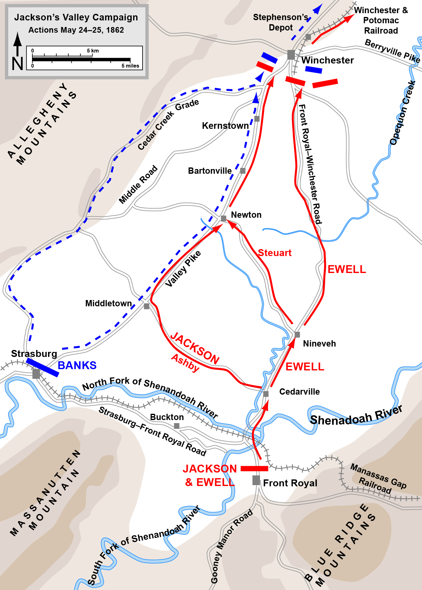
English: Map of part of Jackson's Valley Campaign (actions from Front Royal to First Winchester, May 23-24, 1862) of the American Civil War. |
| Date | |
| Source | Own work based on graphic source file, available at http://www.posix.com/CWmaps/. Compare to map on p. 314 of Shenandoah 1862 by Peter Cozzens for confirmation of accuracy. |
| Author | Hal Jespersen at Wikipedia |
| Permission (Reusing this file) |
CC-BY-3.0. |
| PNG development | This map was created with Adobe Illustrator. |
Licensing
[edit]
Hal Jespersen at en.wikipedia, the copyright holder of this work, hereby publishes it under the following license:
This file is licensed under the Creative Commons Attribution 3.0 Unported license.
Attribution: Map by Hal Jespersen, www.posix.com/CW
- You are free:
- to share – to copy, distribute and transmit the work
- to remix – to adapt the work
- Under the following conditions:
- attribution – You must give appropriate credit, provide a link to the license, and indicate if changes were made. You may do so in any reasonable manner, but not in any way that suggests the licensor endorses you or your use.
Original upload log
[edit]
The original description page was here. All following user names refer to en.wikipedia.
- 2009-07-09 22:20 Hlj 1345×1880× (373194 bytes) {{Information |Description=Map of part of [[Jackson's Valley Campaign]] (actions from Front Royal to First Winchester, May 23-24, 1862) of the [[American Civil War]]. Drawn in Adobe Illustrator CS3 by Hal Jespersen. Graphic source file is available at htt
File history
Click on a date/time to view the file as it appeared at that time.
| Date/Time | Thumbnail | Dimensions | User | Comment | |
|---|---|---|---|---|---|
| current | 21:55, 30 March 2011 | | 1,344 × 1,878 (444 KB) | Hlj (talk | contribs) | Updated graphical formats for rivers and roads. Same license. |
| 16:10, 24 January 2010 |  | 1,345 × 1,880 (364 KB) | BotMultichill (talk | contribs) | {{BotMoveToCommons|en.wikipedia|year={{subst:CURRENTYEAR}}|month={{subst:CURRENTMONTHNAME}}|day={{subst:CURRENTDAY}}}} {{Information |Description={{en|Map of part of en:Jackson's Valley Campaign (actions from Front Royal to First Winchester, May 2 |
You cannot overwrite this file.
File usage on Commons
There are no pages that use this file.
File usage on other wikis
The following other wikis use this file:
- Usage on azb.wikipedia.org
- Usage on en.wikipedia.org
- Usage on es.wikipedia.org
- Usage on fr.wikipedia.org
- Usage on it.wikipedia.org
- Usage on ja.wikipedia.org
- Usage on nl.wikipedia.org
- Usage on no.wikipedia.org
- Usage on ru.wikipedia.org
- Usage on simple.wikipedia.org
- Usage on vi.wikipedia.org