File:French Service géographique de l'armée, Abou Kémâl (FL155910495 4084049).jpg
Jump to navigation
Jump to search

Size of this preview: 482 × 600 pixels. Other resolutions: 193 × 240 pixels | 386 × 480 pixels | 617 × 768 pixels | 823 × 1,024 pixels | 1,645 × 2,048 pixels | 14,434 × 17,965 pixels.
Original file (14,434 × 17,965 pixels, file size: 253.27 MB, MIME type: image/jpeg)
Captions
Captions
Add a one-line explanation of what this file represents
Summary
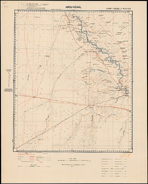
[edit]| Service géographique de l'armée: Abou Kémâl
( |
||||||||||||||||||||||||
|---|---|---|---|---|---|---|---|---|---|---|---|---|---|---|---|---|---|---|---|---|---|---|---|---|
| Artist |
|
|||||||||||||||||||||||
| Title |
Abou Kémâl |
|||||||||||||||||||||||
| Publisher |
Service géographique des Forces françaises libres au Levant |
|||||||||||||||||||||||
| Description |
Abou Kémâl. Dressé dessiné et publié par le Service Géographique des F.F.L. |
|||||||||||||||||||||||
| Language | French, English | |||||||||||||||||||||||
| Publication date | 1945 | |||||||||||||||||||||||
| Medium | 1 sheet : color ; | |||||||||||||||||||||||
| Dimensions | height: 75 cm (29.5 in); width: 60 cm (23.6 in) | |||||||||||||||||||||||
| Collection |
|
|||||||||||||||||||||||
| Current location |
|
|||||||||||||||||||||||
| Place of publication | unknown | |||||||||||||||||||||||
| Notes |
English: Levant 1:200,000 ; NI 37 - XVII | |||||||||||||||||||||||
| scale | 1:200,000 cm | |||||||||||||||||||||||
| IE PID | IE155910492 | |||||||||||||||||||||||
| Rosetta filename | FL155910495 | |||||||||||||||||||||||
| NNL item ID (P3959) | 990040840490205171 | |||||||||||||||||||||||
| search Merhav catalog | French, English, Service géographique de l'armée, unknown | |||||||||||||||||||||||
| search Merhav catalog | Service géographique des Forces françaises libres au Levant | |||||||||||||||||||||||
| Source/Photographer |
|
|||||||||||||||||||||||
| Other versions | ||||||||||||||||||||||||
| Jpg / Tif version |
|
|||||||||||||||||||||||

.jpg)

.jpg&action=edit§ion=1)
Licensing
[edit].jpg&action=edit§ion=2)
This work is in the public domain in France for one of the following reasons:
|
 |
File history
Click on a date/time to view the file as it appeared at that time.
| Date/Time | Thumbnail | Dimensions | User | Comment | |
|---|---|---|---|---|---|
| current | 11:04, 28 July 2023 | | 14,434 × 17,965 (253.27 MB) | Geagea (talk | contribs) | c:User:Rillke/bigChunkedUpload.js: =={{int:filedesc}}== {{Artwork |artist = {{Creator|wikidata=Q113330132}} |author = |title = Abou Kémâl |description = Abou Kémâl. Dressé dessiné et publié par le Service Géographique des F.F.L. |language = {{Label|1=Q150}}, {{Label|1=Q1860}} |date = |publication date = 1945 |medium = 1 sheet : color ; |dimensions = {{size|cm|75|60}} |institution = {{Institution:Eran Laor Cartographic Collection}} |department = {{Institution:National Library... |
You cannot overwrite this file.
File usage on Commons
The following page uses this file:
.jpg&oldid=787575160)