File:France map Lambert-93 with regions and departments-occupation.svg
Jump to navigation
Jump to search

Size of this PNG preview of this SVG file: 632 × 600 pixels. Other resolutions: 253 × 240 pixels | 506 × 480 pixels | 809 × 768 pixels | 1,079 × 1,024 pixels | 2,158 × 2,048 pixels | 1,996 × 1,894 pixels.
Original file (SVG file, nominally 1,996 × 1,894 pixels, file size: 745 KB)
Captions
Captions
Add a one-line explanation of what this file represents
Summary
[edit]| Description |
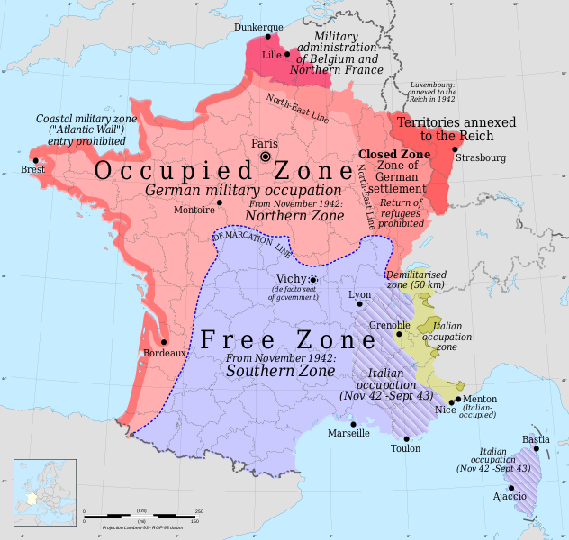
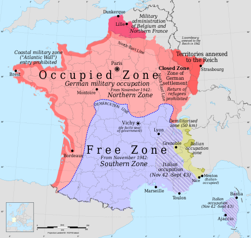
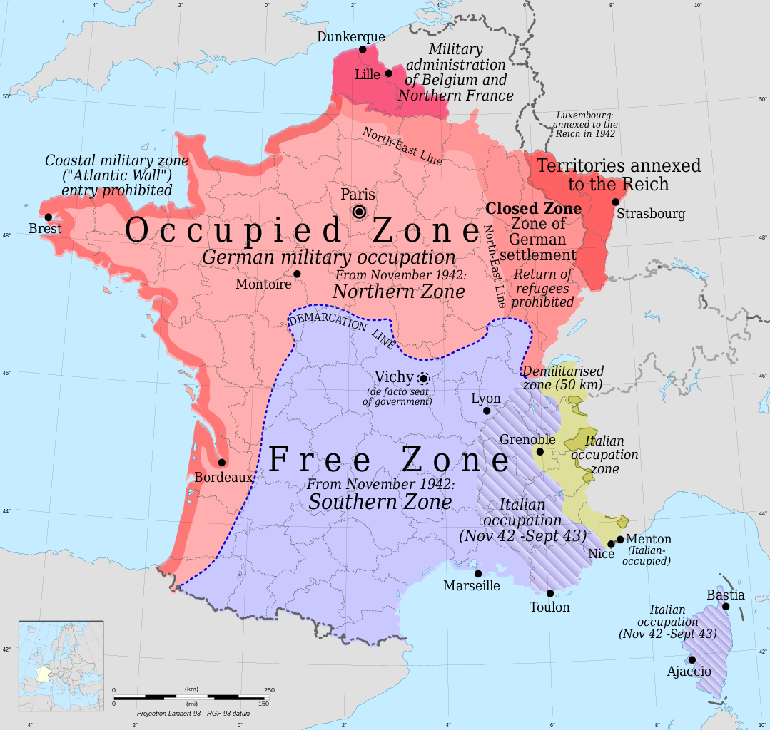
English: Occupation zones of France during the Second World War - English version
Français : Carte de France : les zones françaises occupées pendant la Seconde Guerre mondiale, version anglaise |
| Date | |
| Source |
Own work
|
| Author | Rama for zones |
| Permission (Reusing this file) |
GFDL / Attribution and Share-Alike required |
| Other versions |
versions[edit]
|


Licensing
[edit]
I, the copyright holder of this work, hereby publish it under the following licenses:

|
Permission is granted to copy, distribute and/or modify this document under the terms of the GNU Free Documentation License, Version 1.2 or any later version published by the Free Software Foundation; with no Invariant Sections, no Front-Cover Texts, and no Back-Cover Texts. A copy of the license is included in the section entitled GNU Free Documentation License. |
This file is licensed under the Creative Commons Attribution-Share Alike 4.0 International, 3.0 Unported, 2.5 Generic, 2.0 Generic and 1.0 Generic license.
- You are free:
- to share – to copy, distribute and transmit the work
- to remix – to adapt the work
- Under the following conditions:
- attribution – You must give appropriate credit, provide a link to the license, and indicate if changes were made. You may do so in any reasonable manner, but not in any way that suggests the licensor endorses you or your use.
- share alike – If you remix, transform, or build upon the material, you must distribute your contributions under the same or compatible license as the original.
You may select the license of your choice.
File history
Click on a date/time to view the file as it appeared at that time.
| Date/Time | Thumbnail | Dimensions | User | Comment | |
|---|---|---|---|---|---|
| current | 03:37, 17 October 2022 | | 1,996 × 1,894 (745 KB) | Archiwald (talk | contribs) | File uploaded using svgtranslate tool (https://svgtranslate.toolforge.org/). Added translation for pl. |
| 15:50, 15 May 2022 |  | 1,996 × 1,894 (728 KB) | Ispanas (talk | contribs) | File uploaded using svgtranslate tool (https://svgtranslate.toolforge.org/). Added translation for lt. | |
| 15:49, 15 May 2022 |  | 1,996 × 1,894 (726 KB) | Ispanas (talk | contribs) | File uploaded using svgtranslate tool (https://svgtranslate.toolforge.org/). Added translation for lt. | |
| 22:32, 8 March 2011 |  | 1,996 × 1,894 (698 KB) | Rama (talk | contribs) | Closed zone and North-East line | |
| 22:50, 19 July 2010 |  | 1,996 × 1,894 (694 KB) | Beao (talk | contribs) | Removed border. | |
| 16:27, 28 November 2008 |  | 2,000 × 1,898 (897 KB) | Rama (talk | contribs) | ||
| 08:44, 28 November 2008 |  | 2,000 × 1,898 (895 KB) | Rama (talk | contribs) | ||
| 23:42, 27 November 2008 |  | 2,000 × 1,898 (899 KB) | Rama (talk | contribs) | ||
| 23:27, 27 November 2008 |  | 2,000 × 1,898 (899 KB) | Rama (talk | contribs) | ||
| 21:22, 27 November 2008 |  | 2,000 × 1,898 (897 KB) | Rama (talk | contribs) |
You cannot overwrite this file.
File usage on Commons
The following 24 pages use this file:
- User:Magog the Ogre/Maps of conflicts/2022 May
- User:Magog the Ogre/Maps of conflicts/2022 October
- User:Magog the Ogre/Multilingual legend/2022 May 11-20
- User:Magog the Ogre/Multilingual legend/2022 October 11-20
- File:France map Lambert-93 topographic-demarcation line.svg
- File:France map Lambert-93 with regions and departments-occupation-be.svg
- File:France map Lambert-93 with regions and departments-occupation-de.svg
- File:France map Lambert-93 with regions and departments-occupation-el.svg
- File:France map Lambert-93 with regions and departments-occupation-eo.svg
- File:France map Lambert-93 with regions and departments-occupation-fr.svg
- File:France map Lambert-93 with regions and departments-occupation-hr.svg
- File:France map Lambert-93 with regions and departments-occupation-it.svg
- File:France map Lambert-93 with regions and departments-occupation-nl.svg
- File:France map Lambert-93 with regions and departments-occupation-pt.svg
- File:France map Lambert-93 with regions and departments-occupation-ru.svg
- File:France map Lambert-93 with regions and departments-occupation-sr.svg
- File:France map Lambert-93 with regions and departments-occupation.svg
- File:France map Lambert-93 with regions and departments-occupation He.svg
- File:France map Lambert 93 with regions-hu.svg
- File:Issy-L'Évêque - carte zone occupée.png
- File:Vichy France Map.jpg
- Template:France map Lambert-93 with regions and departments-occupation
- Category:Italian occupation in France
- Category:Resistance in Lyon
File usage on other wikis
The following other wikis use this file:
- Usage on als.wikipedia.org
- Usage on ar.wikipedia.org
- Usage on az.wikipedia.org
- Usage on bg.wikipedia.org
- Usage on el.wikipedia.org
- Usage on en.wikipedia.org
- Axis powers
- Military history of Italy during World War II
- Pierre Laval
- Timeline of SOE French Section
- Wilhelm Stuckart
- Mediterranean and Middle East theatre of World War II
- Legion of French Volunteers Against Bolshevism
- Camp de Rivesaltes
- Vichy France
- Italian irredentism in Savoy
- Zone interdite
- Franco-Italian Armistice
- User:Sasuke Sarutobi/Military occupation of France
- Historiography of the Battle of France
- Royal Air Force Special Duties Service
- Joseph Aveline
- Morocco in World War II
- Government of Vichy France
- Underground media in German-occupied France
- Timeline of SOE's Prosper Network
- Constitutional law of 2 November 1945
- Black market in wartime France
- Grenoble's Saint-Bartholomew
- User:Falcaorib/France
- Usage on et.wikipedia.org
- Usage on fa.wikipedia.org
- Usage on fi.wikipedia.org
- Usage on fr.wikipedia.org
- Usage on he.wikipedia.org
- Usage on hy.wikipedia.org
- Usage on id.wikipedia.org
- Usage on is.wikipedia.org
- Usage on it.wikipedia.org
- Usage on ja.wikipedia.org
- Usage on jv.wikipedia.org
View more global usage of this file.