File:Fort Pulaski National Monument, Georgia LOC 93683157.tif
Jump to navigation
Jump to search

Size of this JPG preview of this TIF file: 800 × 378 pixels. Other resolutions: 320 × 151 pixels | 640 × 302 pixels | 1,024 × 483 pixels | 1,280 × 604 pixels | 2,560 × 1,208 pixels | 10,153 × 4,791 pixels.
Original file (10,153 × 4,791 pixels, file size: 139.17 MB, MIME type: image/tiff)
Captions
Captions
Add a one-line explanation of what this file represents
Summary
[edit]| Description |
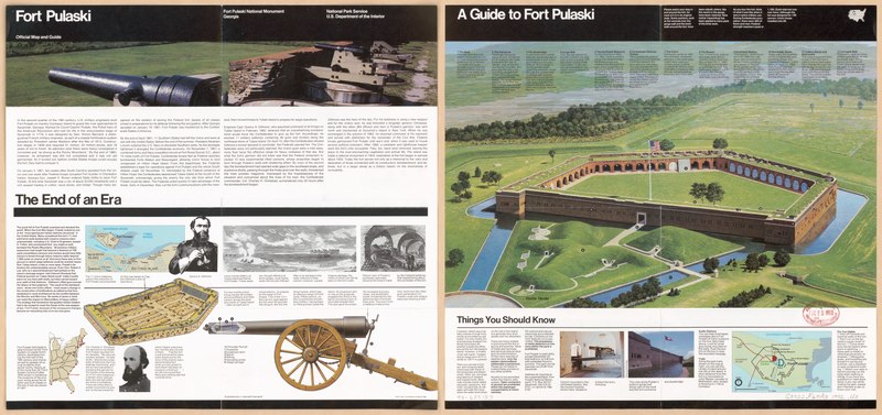
English: Bird's-eye view. "*GPO: 1993--342-398/600150. Reprint 1992." Panel title. Alternate panel title: Fort Pulaski official map and guide. Title at upper left: A guide to Fort Pulaski. Includes ancillary map of Fort Pulaski, text, descriptive index, and col. ill. Map of Fort Pulaski on Cockspur Island and the Union batteries on nearby Big Tybee Island, view showing the penetration of Fort Pulaski's walls by shots from Union cannon, location map, text, and ill. (some col.) on verso. Available also through the Library of Congress Web site as a raster image. |
||
| Title | Fort Pulaski National Monument, Georgia | ||
| Shelf ID | G3922.F67A3 1992 .U5 | ||
| Date | |||
| Source | https://www.loc.gov/item/93683157/ | ||
| Author | United States. National Park Service | ||
| Permission (Reusing this file) |
|
||
| Other versions |
|
||
| Location | United States · Fort Pulaski National Monument. · Georgia · Fort Pulaski National Monument | ||
| Part of | American Memory · General Maps · Catalog · Geography And Map Division | ||
| Subject | United States · Georgia · Aerial Views · Fort Pulaski National Monument (Ga.) · Fort Pulaski National Monument |


Licensing
[edit]| This image or media file contains material based on a work of a National Park Service employee, created as part of that person's official duties. As a work of the U.S. federal government, such work is in the public domain in the United States. See the NPS website and NPS copyright policy for more information. |
File history
Click on a date/time to view the file as it appeared at that time.
| Date/Time | Thumbnail | Dimensions | User | Comment | |
|---|---|---|---|---|---|
| current | 22:18, 5 September 2018 |  | 10,153 × 4,791 (139.17 MB) | Fæ (talk | contribs) | LOC Maps https://www.loc.gov/item/93683157/ #12849 |
You cannot overwrite this file.
File usage on Commons
The following page uses this file: