File:Fort Anderson, Paducah, Ky. LOC 2008627280.tif
Jump to navigation
Jump to search

Size of this JPG preview of this TIF file: 444 × 599 pixels. Other resolutions: 178 × 240 pixels | 355 × 480 pixels | 569 × 768 pixels | 758 × 1,024 pixels | 1,517 × 2,048 pixels | 10,936 × 14,762 pixels.
Original file (10,936 × 14,762 pixels, file size: 461.88 MB, MIME type: image/tiff)
Captions
Captions
Add a one-line explanation of what this file represents
Summary
[edit]| Warning | The original file is very high-resolution. It might not load properly or could cause your browser to freeze when opened at full size. |
|---|
| Description |
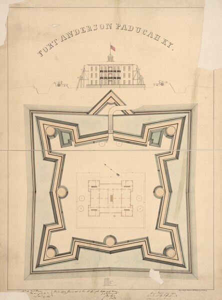
English: Pen-and-ink and watercolor. Oriented with north to the upper left. "Hd. Qr., U.S. Forces, Paducah, Keny., Jany. 4, 1861. Respectfully forwarded to the Hd. Qr. of the Dept. of the Missi., [signed] C. F. Smith, Brigr. Genl., comdg." "Engr. Dept., July 18/64. Recd. with Gen. Cullum's letter of the 16th inst. (C.5621)." Imperfect: Missing small sections along sheet edges. Mounted on cloth backing in 2 parts. Includes a profile of the main building and list of structures. LC Civil War Maps (2nd ed.), 219 Available also through the Library of Congress Web site as a raster image. |
||
| Title | Fort Anderson, Paducah, Ky. | ||
| Shelf ID | G3954.P2:2F6 1861 .R9 | ||
| Date | |||
| Source | https://www.loc.gov/item/2008627280/ | ||
| Author | Rziha, John | ||
| Permission (Reusing this file) |
|
||
| Other versions |
|
||
| Location | United States · Fort Anderson (Paducah) · Erson · Kentucky · Paducah | ||
| Part of | Military Battles And Campaigns · American Memory · Civil War Maps · Catalog · Geography And Map Division | ||
| Subject | Maps, Manuscript · Fort Anderson (Paducah, Ky.) · Paducah · Fortification · Fort Anderson (Paducah) · Civil War · United States · Maps · Kentucky · History |


Licensing
[edit]|
This is a faithful photographic reproduction of a two-dimensional, public domain work of art. The work of art itself is in the public domain for the following reason:
The official position taken by the Wikimedia Foundation is that "faithful reproductions of two-dimensional public domain works of art are public domain".
This photographic reproduction is therefore also considered to be in the public domain in the United States. In other jurisdictions, re-use of this content may be restricted; see Reuse of PD-Art photographs for details. | ||||
File history
Click on a date/time to view the file as it appeared at that time.
| Date/Time | Thumbnail | Dimensions | User | Comment | |
|---|---|---|---|---|---|
| current | 04:14, 30 May 2018 |  | 10,936 × 14,762 (461.88 MB) | Fæ (talk | contribs) | LOC Maps https://www.loc.gov/item/2008627280/ #15386 |
You cannot overwrite this file.
File usage on Commons
The following page uses this file: