File:Floods in Guthrie, Oklahoma, LOC gm71001990.tif
Jump to navigation
Jump to search

Size of this JPG preview of this TIF file: 800 × 479 pixels. Other resolutions: 320 × 192 pixels | 640 × 383 pixels | 1,024 × 613 pixels | 1,280 × 766 pixels | 2,560 × 1,533 pixels | 8,661 × 5,186 pixels.
Original file (8,661 × 5,186 pixels, file size: 128.51 MB, MIME type: image/tiff)
Captions
Captions
Add a one-line explanation of what this file represents
Summary
[edit]| Description |
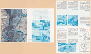
English: Scale ca. 1:12,000. Folded title. Photo mosaic. Includes illus. and flood elevation profile chart. Text and map "Cottonwood Creek watershed" on verso. Available also through the Library of Congress Web site as a raster image. AACR2: 110; 650/1 |
||
| Title | Floods in Guthrie, Oklahoma, | ||
| Shelf ID | G4024.G8C32 1970 .U5 | ||
| Date | |||
| Source | https://www.loc.gov/item/gm71001990/ | ||
| Author | United States. Army. Corps Of Engineers | ||
| Permission (Reusing this file) |
|
||
| Other versions |
|
||
| Location | Cottonwood Creek. · Guthrie. · Oklahoma · Guthrie · United States · Cottonwood Creek | ||
| Part of | American Memory · Cities And Towns · Catalog · Geography And Map Division · Additional Conservation And Environment Cartographic Items | ||
| Subject | Floods · Oklahoma · Guthrie · United States · Remote-Sensing Maps · Cottonwood Creek |


Licensing
[edit]| This work is from the Library of Congress. According to the library, there are no known copyright restrictions on the use of this work. |  |
File history
Click on a date/time to view the file as it appeared at that time.
| Date/Time | Thumbnail | Dimensions | User | Comment | |
|---|---|---|---|---|---|
| current | 13:42, 29 September 2019 |  | 8,661 × 5,186 (128.51 MB) | Fæ (talk | contribs) | LOC Maps https://www.loc.gov/item/gm71001990/ #6068 |
You cannot overwrite this file.
File usage on Commons
The following page uses this file: