File:Finley Map Of The Enigma Outbreak, Feb 19 1884 (7994743682).jpg
Original file (1,528 × 1,116 pixels, file size: 339 KB, MIME type: image/jpeg)
Captions
Captions
Summary
[edit].jpg&action=edit§ion=1)
| Description |
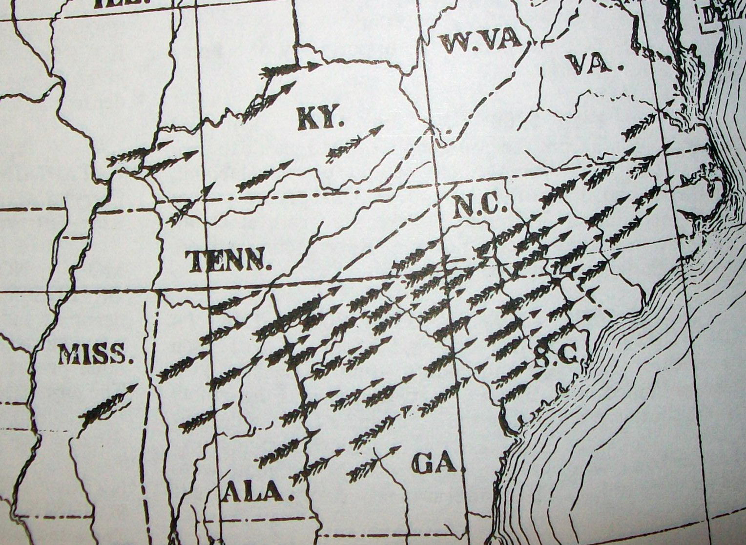
The Enigma Tornado Outbreak took place on February 19 of 1884. Reprint of 1884 Map by J. P. Finley, for the US government, and subsequently published in many meteorological texts. This map charts (roughly) one of the most violent and prolific tornado outbreak to sweep across the Southeast, with rapidly moving 'families' of tornadic storms moving from Alabama to Virginia over about 18 hours. More isolated tornadoes, and intense flash floods also hit locations in Tennessee, Kentucky, Illinois and Indiana. This outbreak remains the most prolific and destructive to ever strike South Carolina or Georgia, and spawned the deadliest tornado ever in North Carolina. That storm directly hit the town of Rockingham. Other towns that experienced severe damage included Leeds Alabama, Columbus Georgia, Athens Georgia, Anderson South Carolina, and Cary North Carolina. One tornado crossing the mountains of north Georgia left a damage path 2 miles wide. Large and destructive tornadoes passed very close to Atlanta, Columbus, Macon, Athens, and Augusta Georgia, without directly striking any of them. The cities of Charlotte and Raleigh in North Carolina were likewise not directly struck, but multiple supecell thunderstorms crossed both cities without spawning tornadoes, over a period of just a few hours. Large tornadoes that began between Charlotte and Fayetteville tracked through Iredell and Davie Counties (1st tornado), Cabarrus, Stanly and Montgomery Counties (2nd tornado), Union, Anson, Richmond and Montgomery Counties (3rd tornado), and Anson, Moore, Hoke and Harnett Counties (4th tornado), all leaving tremendous damage in their wake. The last significant damage was just to the northwest of Petersburg, Virginia. |
| Date | |
| Source | Finley Map Of The Enigma Outbreak, Feb 19 1884 |
| Author | davecito |
| Camera location | | View this and other nearby images on: OpenStreetMap |
|---|
.jpg¶ms=035.428015_N_-080.588428_E_globe:Earth_type:camera_source:Flickr_&language=en)
Licensing
[edit].jpg&action=edit§ion=2)
- You are free:
- to share – to copy, distribute and transmit the work
- to remix – to adapt the work
- Under the following conditions:
- attribution – You must give appropriate credit, provide a link to the license, and indicate if changes were made. You may do so in any reasonable manner, but not in any way that suggests the licensor endorses you or your use.
| This image was originally posted to Flickr by davecito at https://flickr.com/photos/23465812@N00/7994743682. It was reviewed on 19 December 2021 by FlickreviewR 2 and was confirmed to be licensed under the terms of the cc-by-2.0. |
File history
Click on a date/time to view the file as it appeared at that time.
| Date/Time | Thumbnail | Dimensions | User | Comment | |
|---|---|---|---|---|---|
| current | 11:27, 19 December 2021 | | 1,528 × 1,116 (339 KB) | Siloepic (talk | contribs) | Transferred from Flickr via #flickr2commons |
You cannot overwrite this file.
File usage on Commons
There are no pages that use this file.
.jpg&oldid=887697081)