File:Favignana, Levanzo and western Sicily ESA416961.tiff

Original file (4,051 × 3,059 pixels, file size: 70.93 MB, MIME type: image/tiff)
Captions
Captions
Summary
[edit]| Description |
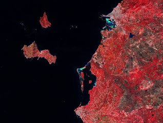
English: Captured on 3 September 2018 by the Copernicus Sentinel-2A satellite, this image shows part of western Sicily in Italy and two of the main Aegadian Islands: Favignana and Levanzo.
This false-colour image included the near-infrared channel and was processed in a way, that makes vegetation appear in bright red. The bright turquoise colours, near the port city of Trapani, at the top of the image, and the Isola Grande in the middle of the image, depict salt marshes. Both the Saline di Trapani e Paceco Nature Reserve and the Stagnone Nature Reserve with their shallow sea waters, windy coast and abundant sunshine, make the area between Marsala, at the bottom of the image, and Trapani an ideal place for salt production. The reserve consists of more than 1000 hectares of landscape dotted with windmills, migratory birds such as flamingos and light-red lagoons visible in summer. This greenish-blue colour is heavily contrasted with the black of the open Mediterranean Sea. The islands, off the coast, are rich in history, both boasting Paleolithic and Neolithic cave paintings. The most famous being the Grotta del Genovese on the picturesque island of Levanzo, at the top left of the image. The cave was discovered only in 1949 and is estimated to be between 6000 and 10 000 years old. Below, the butterfly-shaped island of Favignana, known for its tuna fisheries and a type of limestone known as tufa rock, is the largest of the Aegadian islands. In 241 BC, one of the Punic Wars’ naval battles was fought at the Cala Rossa (Red Cove), named after the bloodshed. Copernicus Sentinel-2 is a two-satellite mission. Each satellite carries a high-resolution camera that images Earth’s surface in 13 spectral bands. The mission is mostly used to track changes in the way land is being used and to monitor the health of our vegetation. This image is also featured on theEarth from Space video programme. |
| Date | |
| Source | http://www.esa.int/spaceinimages/Images/2019/02/Favignana_Levanzo_and_western_Sicily |
| Author | European Space Agency |
| Permission (Reusing this file) |
contains modified Copernicus Sentinel data (2018), processed by ESA,CC BY-SA 3.0 IGO |
| Title | Favignana, Levanzo and western Sicily |
| System | Copernicus |
| Set | Earth observation image of the week |
| Mission | Sentinel-2 |
| Activity | Observing the Earth |
Licensing
[edit]- You are free:
- to share – to copy, distribute and transmit the work
- to remix – to adapt the work
- Under the following conditions:
- attribution – You must give appropriate credit, provide a link to the license, and indicate if changes were made. You may do so in any reasonable manner, but not in any way that suggests the licensor endorses you or your use.
- share alike – If you remix, transform, or build upon the material, you must distribute your contributions under the same or compatible license as the original.

|
This image contains data from a satellite in the Copernicus Programme, such as Sentinel-1, Sentinel-2 or Sentinel-3. Attribution is required when using this image.
Attribution: Contains modified Copernicus Sentinel data {{{year}}}
The use of Copernicus Sentinel Data is regulated under EU law (Commission Delegated Regulation (EU) No 1159/2013 and Regulation (EU) No 377/2014). Relevant excerpts:
Free access shall be given to GMES dedicated data [...] made available through GMES dissemination platforms [...].
Access to GMES dedicated data [...] shall be given for the purpose of the following use in so far as it is lawful:
GMES dedicated data [...] may be used worldwide without limitations in time.
GMES dedicated data and GMES service information are provided to users without any express or implied warranty, including as regards quality and suitability for any purpose. |
File history
Click on a date/time to view the file as it appeared at that time.
| Date/Time | Thumbnail | Dimensions | User | Comment | |
|---|---|---|---|---|---|
| current | 12:59, 3 April 2019 |  | 4,051 × 3,059 (70.93 MB) | Fæ (talk | contribs) | European Space Agency, Id 416961, http://www.esa.int/spaceinimages/Images/2019/02/Favignana_Levanzo_and_western_Sicily, User:Fæ/Project_list/ESA |
You cannot overwrite this file.
File usage on Commons
The following page uses this file: