File:Europe islands.svg
Jump to navigation
Jump to search

Size of this PNG preview of this SVG file: 700 × 545 pixels. Other resolutions: 308 × 240 pixels | 617 × 480 pixels | 987 × 768 pixels | 1,280 × 997 pixels | 2,560 × 1,993 pixels.
Original file (SVG file, nominally 700 × 545 pixels, file size: 1.78 MB)
Captions
Captions
Add a one-line explanation of what this file represents
Summary
[edit]
| Description |
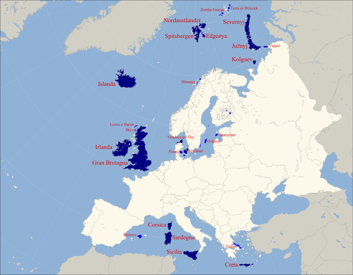
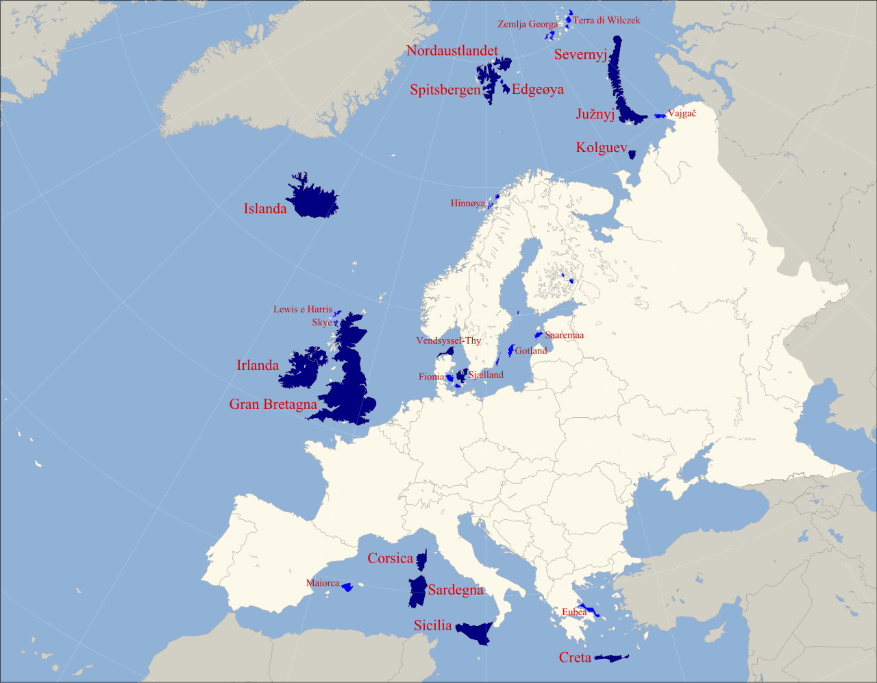
English: map of islands of Europe, first 15 bigger islands are named, first 35 are colored dark blue > 4000 km2 and light blue < 4000 km2 |
| Date | (UTC) |
| Source |
This file was derived from: Europe polar stereographic Caucasus Urals boundary.svg: |
| Author |
|
_cropped.svg)
| This is a retouched picture, which means that it has been digitally altered from its original version. Modifications: Color map of islands. The original can be viewed here: Europe polar stereographic Caucasus Urals boundary.svg:
|
Licensing
[edit]
I, the copyright holder of this work, hereby publish it under the following licenses:
This file is licensed under the Creative Commons Attribution-Share Alike 3.0 Unported license.
- You are free:
- to share – to copy, distribute and transmit the work
- to remix – to adapt the work
- Under the following conditions:
- attribution – You must give appropriate credit, provide a link to the license, and indicate if changes were made. You may do so in any reasonable manner, but not in any way that suggests the licensor endorses you or your use.
- share alike – If you remix, transform, or build upon the material, you must distribute your contributions under the same or compatible license as the original.

|
Permission is granted to copy, distribute and/or modify this document under the terms of the GNU Free Documentation License, Version 1.2 or any later version published by the Free Software Foundation; with no Invariant Sections, no Front-Cover Texts, and no Back-Cover Texts. A copy of the license is included in the section entitled GNU Free Documentation License. |
The map has been created with the Generic Mapping Tools: https://www.generic-mapping-tools.org/ using one or more of these public-domain datasets for the relief:
|
|
|
Permission is granted to copy, distribute and/or modify this document under the terms of the GNU Free Documentation License, Version 1.2 or any later version published by the Free Software Foundation; with no Invariant Sections, no Front-Cover Texts, and no Back-Cover Texts. A copy of the license is included in the section entitled GNU Free Documentation License. |
You may select the license of your choice.
Original upload log
[edit]
This image is a derivative work of the following images:
- File:Europe_polar_stereographic_Caucasus_Urals_boundary.svg licensed with Cc-by-sa-3.0, GFDL, GFDL-GMT
- 2013-09-01T06:30:05Z Fulvio314 700x545 (1380920 Bytes) Areas and borders fine alignment
- 2012-02-15T16:51:45Z Artem Karimov 700x545 (1146041 Bytes) either include all separatists or none
- 2011-11-29T06:20:06Z Wsiegmund 700x545 (1593086 Bytes) Reverted to version as of 07:04, 11 April 2011; ; do not upload over existing version without consensus.
- 2011-11-28T05:28:04Z Geogen 700x545 (211693 Bytes)
- 2011-11-28T04:28:01Z Geagea 700x545 (1593086 Bytes) Reverted to version as of 14:15, 28 April 2011
- 2011-11-28T02:19:34Z Geogen 700x545 (211693 Bytes) Kura definition
- 2011-04-28T14:15:35Z Wsiegmund 700x545 (1593086 Bytes) Reverted to version as of 07:04, 11 April 2011; previous uploader is blocked (inappropriate username).
- 2011-04-28T14:06:32Z Wseigmund 700x545 (211693 Bytes) Reverted to version as of 07:04, 11 April 2011; do not upload over existing version without consensus.
- 2011-04-13T02:27:24Z Wsiegmund 700x545 (1593086 Bytes) Reverted to version as of 07:04, 11 April 2011; do not upload over existing version without consensus.
- 2011-04-12T15:09:20Z Çhipmunkdavis 700x545 (211693 Bytes) Reverted to version as of 06:24, 12 April 2011
- 2011-04-12T12:45:43Z Bidgee 700x545 (1593086 Bytes) Reverted to version as of 07:04, 11 April 2011 Do not upload over existing images
- 2011-04-12T06:24:52Z ComtesseDeMingrelie 700x545 (211693 Bytes) rv. to consensus based boundary
- 2011-04-11T07:04:22Z Dbachmann 700x545 (1593086 Bytes) {{Information |Description={{en|1=A blank map of Europe. The continental boundary to Asia indicated follows the standard convention of the crest of the Greater Caucasus, the Urals River and the Urals Mountains to the Sea of K
Uploaded with derivativeFX
File history
Click on a date/time to view the file as it appeared at that time.
| Date/Time | Thumbnail | Dimensions | User | Comment | |
|---|---|---|---|---|---|
| current | 17:21, 6 September 2013 | | 700 × 545 (1.78 MB) | Fulvio314 (talk | contribs) | {{Information |Description={{en|1=map of islands of Europe}} |Source={{Derived from|Europe_polar_stereographic_Caucasus_Urals_boundary.svg|display=50}} |Date=2013-09-06 17:17 (UTC) |Author=*[[:File:Europe_polar_stereographic_Caucasus_Urals_boundary.svg... |
You cannot overwrite this file.
File usage on Commons
The following page uses this file:
File usage on other wikis
The following other wikis use this file: