File:Europe alcohol belts.svg
Jump to navigation
Jump to search

Size of this PNG preview of this SVG file: 688 × 599 pixels. Other resolutions: 276 × 240 pixels | 551 × 480 pixels | 881 × 768 pixels | 1,175 × 1,024 pixels | 2,350 × 2,048 pixels | 1,500 × 1,307 pixels.
Original file (SVG file, nominally 1,500 × 1,307 pixels, file size: 792 KB)
Captions
Captions
Add a one-line explanation of what this file represents
Summary
[edit]
| Description |
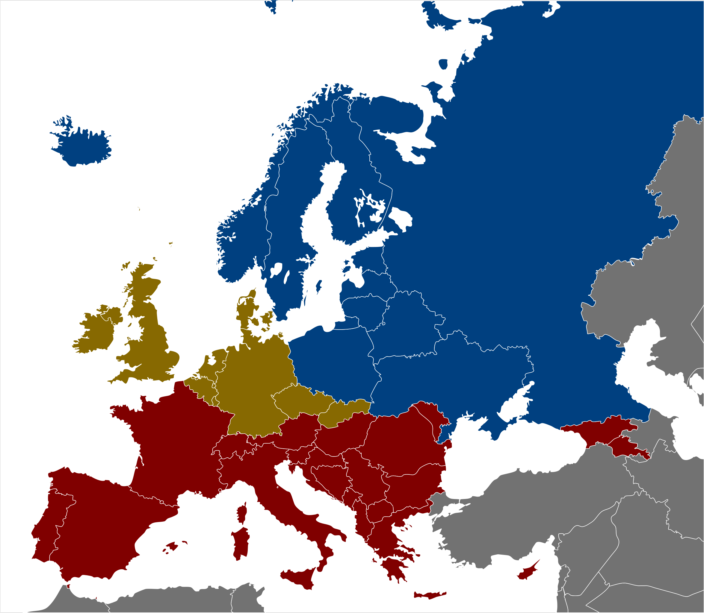
English (en): Alcohol map of Europe. This map shows the traditional and historic alcoholic drink of various countries and regions in Europe.
Vodka Wine Beer
|
| Date | |
| Source | Own work based on Europe regions.svg by Sertmann (Stefan Ertmann), which is based on Blank map of Europe - Atelier graphique colors.svg by Historicair. |
| Author | Globe-trotter |
| Other versions | Europe alcohol belts.png |
Licensing
[edit]
This file is licensed under the Creative Commons Attribution-Share Alike 2.5 Generic license.
- You are free:
- to share – to copy, distribute and transmit the work
- to remix – to adapt the work
- Under the following conditions:
- attribution – You must give appropriate credit, provide a link to the license, and indicate if changes were made. You may do so in any reasonable manner, but not in any way that suggests the licensor endorses you or your use.
- share alike – If you remix, transform, or build upon the material, you must distribute your contributions under the same or compatible license as the original.
Original upload log
[edit]
| This file was imported from Wikivoyage WTS. |
The original description page was here. All following user names refer to wts.wikivoyage-old.
- 2011-11-03 01:48 (WT-shared) Globe-trotter[dead link] 1500×1307 (827483 bytes) {{Imagecredit|credit=made by Globe-trotter, based on Stefan Ertmann's [http://wikitravel.org/shared/User:Sertmann] map [http://wikitravel.or (Import from wikitravel.org/shared)
- 2012-09-13 11:42 ImportBot[dead link] 1500×1307 (811890 bytes) rm WT-logo
File history
Click on a date/time to view the file as it appeared at that time.
| Date/Time | Thumbnail | Dimensions | User | Comment | |
|---|---|---|---|---|---|
| current | 08:28, 24 May 2016 | | 1,500 × 1,307 (792 KB) | Ricordisamoa (talk | contribs) | white lakes too |
| 08:26, 24 May 2016 |  | 1,500 × 1,307 (792 KB) | Ricordisamoa (talk | contribs) | white ocean to match File:Europe alcohol belts.png | |
| 08:18, 24 May 2016 |  | 1,500 × 1,307 (792 KB) | Ricordisamoa (talk | contribs) | remove flowRoot (black rect) | |
| 03:15, 13 December 2012 |  | 1,500 × 1,307 (793 KB) | OgreBot (talk | contribs) | (BOT): Reverting to most recent version before archival | |
| 03:15, 13 December 2012 |  | 1,500 × 1,307 (808 KB) | OgreBot (talk | contribs) | (BOT): Uploading old version of file from wts.wikivoyage; originally uploaded on 2011-11-03 01:48:36 by (WT-shared) Globe-trotter | |
| 23:39, 17 November 2012 |  | 1,500 × 1,307 (793 KB) | MGA73bot2 (talk | contribs) | {{BotMoveToCommons|wts.oldwikivoyage|year={{subst:CURRENTYEAR}}|month={{subst:CURRENTMONTHNAME}}|day={{subst:CURRENTDAY}}}} == {{int:filedesc}} == {{Information |description=Alcohol map of Europe. This map shows the traditional and historic alcoholic d... |
You cannot overwrite this file.
File usage on Commons
The following 2 pages use this file:
File usage on other wikis
The following other wikis use this file:
- Usage on en.wikipedia.org
- Usage on fa.wikipedia.org
- Usage on nl.wikipedia.org