File:Euro-Map-all.png
Jump to navigation
Jump to search

Size of this preview: 571 × 599 pixels. Other resolutions: 229 × 240 pixels | 458 × 480 pixels | 732 × 768 pixels | 976 × 1,024 pixels | 1,918 × 2,012 pixels.
Original file (1,918 × 2,012 pixels, file size: 329 KB, MIME type: image/png)
Captions
Captions
Add a one-line explanation of what this file represents
Summary
[edit]
| Description |
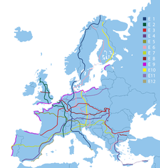
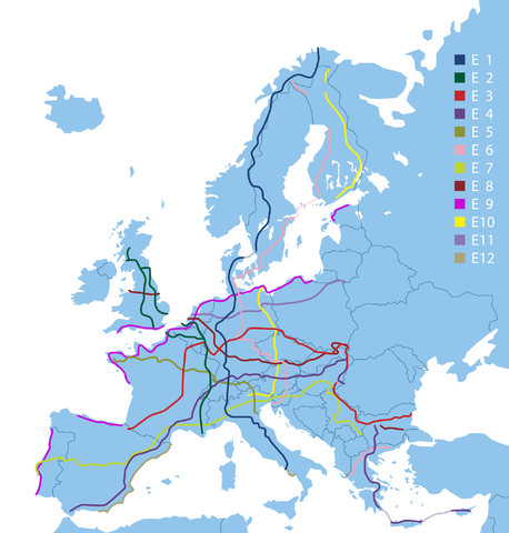
English: Map of European long-distance paths (E1 ... E12)
Deutsch: Karte aller Europäischen Fernwanderwege (E1 ... E12) |
| Date | Stand 2013 |
| Source | Markierung der E-Wege |
| Author | Europäische Wandervereinigung |
| Permission (Reusing this file) |
Präsidentin der EWV, Lis Nielsen, lt. Mail v. Martina Zikmundova an Friedo, Prag, 2. Juli 2014, 12:39 |
Datei als PDF erhalten am 8. Juli 2014 um 13.27 Uhr

|
File:European long-distance paths.svg is a vector version of this file. It should be used in place of this PNG file when not inferior.
File:Euro-Map-all.png → File:European long-distance paths.svg
For more information, see Help:SVG. |
 |
Diese ist allerdings etwas älter und enthält nicht Nordeuropa.
Licensing
[edit]
This file is licensed under the Creative Commons Attribution-Share Alike 3.0 Unported license.
- You are free:
- to share – to copy, distribute and transmit the work
- to remix – to adapt the work
- Under the following conditions:
- attribution – You must give appropriate credit, provide a link to the license, and indicate if changes were made. You may do so in any reasonable manner, but not in any way that suggests the licensor endorses you or your use.
- share alike – If you remix, transform, or build upon the material, you must distribute your contributions under the same or compatible license as the original.
File history
Click on a date/time to view the file as it appeared at that time.
| Date/Time | Thumbnail | Dimensions | User | Comment | |
|---|---|---|---|---|---|
| current | 21:01, 8 July 2014 | | 1,918 × 2,012 (329 KB) | FkMohr (talk | contribs) | {{Information |Description ={{en|1=Map of european long-distance-trails (E1 ... E12)}} {{de|1=Karte aller Europäischen Fernwanderwege (E1 ... E12)}} |Source =[http://www.era-ewv-ferp.com/de/wandern-in-europa/e-wege/markierung-der-e-wege/ Ma... |
You cannot overwrite this file.
File usage on Commons
The following 14 pages use this file:
- File:Map of the European Long Distance Path E1.png
- File:Map of the European Long Distance Path E10.png
- File:Map of the European Long Distance Path E11.png
- File:Map of the European Long Distance Path E12.png
- File:Map of the European Long Distance Path E2.png
- File:Map of the European Long Distance Path E3.png
- File:Map of the European Long Distance Path E4.png
- File:Map of the European Long Distance Path E5.png
- File:Map of the European Long Distance Path E6.png
- File:Map of the European Long Distance Path E7.png
- File:Map of the European Long Distance Path E8.png
- File:Map of the European Long Distance Path E9.png
- File:Map of the European Long Distance Paths.png
- File:Map of the European long distance paths.svg
File usage on other wikis
The following other wikis use this file:
- Usage on de.wikipedia.org