File:Entrada Sandstone Red Wash.jpg
Jump to navigation
Jump to search

Size of this preview: 799 × 599 pixels. Other resolutions: 320 × 240 pixels | 640 × 480 pixels | 1,024 × 768 pixels | 1,280 × 960 pixels | 2,560 × 1,920 pixels | 2,949 × 2,212 pixels.
Original file (2,949 × 2,212 pixels, file size: 2.2 MB, MIME type: image/jpeg)
Captions
Captions
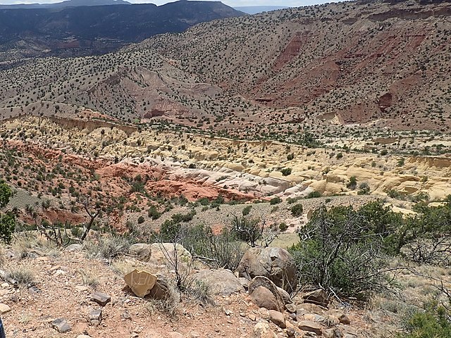
Entrada Sandstone at Red Wash Canyon, near Abiquiu,New Mexico, USA
Summary
[edit]
| Description |
English: This image shows colorful beds of the Entrada Sandstone near Red Wash Canyon, west of Abiquiu, New Mexico, USA. The beds are capped by thin grey beds of the Todilto Formation. The escarpment in the background is underlain by much older Permian beds of the Arroyo del Agua Formation, with the Canones Fault at the base of the escarpment. The Canones Fault marks the southeastern boundary of the Colorado Plateau with the Rio Grande rift in this area. |
| Date | |
| Source | Own work |
| Author | Kent G. Budge |
| Camera location | | View this and other nearby images on: OpenStreetMap |
|---|
Licensing
[edit]
I, the copyright holder of this work, hereby publish it under the following license:
| This file is made available under the Creative Commons CC0 1.0 Universal Public Domain Dedication. | |
| The person who associated a work with this deed has dedicated the work to the public domain by waiving all of their rights to the work worldwide under copyright law, including all related and neighboring rights, to the extent allowed by law. You can copy, modify, distribute and perform the work, even for commercial purposes, all without asking permission.
|
File history
Click on a date/time to view the file as it appeared at that time.
| Date/Time | Thumbnail | Dimensions | User | Comment | |
|---|---|---|---|---|---|
| current | 23:44, 28 June 2020 | | 2,949 × 2,212 (2.2 MB) | Kent G. Budge (talk | contribs) | Uploaded own work with UploadWizard |
You cannot overwrite this file.
File usage on Commons
There are no pages that use this file.
File usage on other wikis
The following other wikis use this file:
- Usage on en.wikipedia.org