File:Empty House near the A2 and Watling Street - geograph.org.uk - 1556420.jpg
Jump to navigation
Jump to search
No higher resolution available.
Empty_House_near_the_A2_and_Watling_Street_-_geograph.org.uk_-_1556420.jpg (640 × 427 pixels, file size: 70 KB, MIME type: image/jpeg)
Captions
Captions
Add a one-line explanation of what this file represents
Summary
[edit]
| Description |
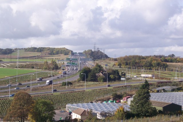
English: Empty House near the A2 and Watling Street The A2 Dual Carriageway is on the left heading towards London from Gravesend and the Medway Towns. The B259 Watling Street leads from the A2 to a roundabout (on the right) leading right to Ebbsfleet Station and left to Pepper Hill,Northfleet. The house beside the roundabout, in the trees has been empty since the start of the construction of the Channel Tunnel Rail Link works in the 90's. Springhead Nursery is in the foreground. |
| Date | |
| Source | From geograph.org.uk |
| Author | David Anstiss |
| Attribution (required by the license) | David Anstiss / Empty House near the A2 and Watling Street / |
| Camera location | | View this and other nearby images on: OpenStreetMap |
|---|
_heading:270.00&language=en)
| Object location | | View this and other nearby images on: OpenStreetMap |
|---|
_heading:270.00&language=en)
Licensing
[edit]

|
This image was taken from the Geograph project collection. See this photograph's page on the Geograph website for the photographer's contact details. The copyright on this image is owned by David Anstiss and is licensed for reuse under the Creative Commons Attribution-ShareAlike 2.0 license.
|
This file is licensed under the Creative Commons Attribution-Share Alike 2.0 Generic license.
Attribution: David Anstiss
- You are free:
- to share – to copy, distribute and transmit the work
- to remix – to adapt the work
- Under the following conditions:
- attribution – You must give appropriate credit, provide a link to the license, and indicate if changes were made. You may do so in any reasonable manner, but not in any way that suggests the licensor endorses you or your use.
- share alike – If you remix, transform, or build upon the material, you must distribute your contributions under the same or compatible license as the original.
File history
Click on a date/time to view the file as it appeared at that time.
| Date/Time | Thumbnail | Dimensions | User | Comment | |
|---|---|---|---|---|---|
| current | 13:01, 3 March 2011 | | 640 × 427 (70 KB) | GeographBot (talk | contribs) | == {{int:filedesc}} == {{Information |description={{en|1=Empty House near the A2 and Watling Street The A2 Dual Carriageway is on the left heading towards London from Gravesend and the Medway Towns. The B259 Watling Street leads from the A2 to a roundabou |
You cannot overwrite this file.
File usage on Commons
There are no pages that use this file.