Category:Northfleet
Jump to navigation
Jump to search
town in the Borough of Gravesham in Kent, England  | |||||
| Upload media | |||||
| Instance of | |||||
|---|---|---|---|---|---|
| Location | Gravesham, Kent, South East England, England | ||||
| Located in or next to body of water | |||||
 | |||||
Subcategories
This category has the following 13 subcategories, out of 13 total.
B
E
- Ellen Gracie Northfleet (16 F)
I
- Ifield Court (2 F)
P
R
- Northfleet railway station (5 F)
S
- The Six Bells, Northfleet (4 F)
Media in category "Northfleet"
The following 199 files are in this category, out of 199 total.
-
 'E' is for Ebbsfleet - geograph.org.uk - 1556450.jpg 640 × 427; 54 KB
-
 'Leonid Sobinov', Tilbury 17-02-1978 - geograph.org.uk - 6341594.jpg 980 × 667; 135 KB
-
 A corner of Gravesend Cemetery - geograph.org.uk - 6522205.jpg 1,024 × 768; 522 KB
-
 A group portrait at Rosherville Gardens, Northfleet RMG G02346.tiff 2,000 × 1,669; 9.55 MB
-
 Aspdin Wharf - geograph.org.uk - 6331371.jpg 3,264 × 2,448; 3.78 MB
-
 Aspdin Wharf - geograph.org.uk - 6331380.jpg 3,264 × 2,320; 2.36 MB
-

-
 Bridleway by railway - geograph.org.uk - 6232500.jpg 1,024 × 768; 399 KB
-
 Bridleway by railway - geograph.org.uk - 6232509.jpg 1,024 × 768; 498 KB
-
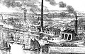
 Cement Kilns, Northfleet, 1973 - geograph.org.uk - 134466.jpg 640 × 421; 53 KB
-
 Chalk faces at Church Path Pit - geograph.org.uk - 5851513.jpg 1,024 × 683; 244 KB
-
 Clements Close Catholic Church - geograph.org.uk - 1250757.jpg 640 × 480; 89 KB
-
 Close up of the village sign at Istead Rise - geograph.org.uk - 6557006.jpg 4,000 × 3,000; 3.14 MB
-
 Close up of the village sign at Istead Rise - geograph.org.uk - 6557009.jpg 4,000 × 3,000; 3.21 MB
-
 Coldharbour Library - geograph.org.uk - 1558318.jpg 640 × 427; 54 KB
-
 Concrete Jetty - geograph.org.uk - 2091893.jpg 800 × 531; 52 KB
-
 Concrete Jetty - geograph.org.uk - 2091908.jpg 800 × 531; 51 KB
-
 Concrete Jetty Bridge - geograph.org.uk - 2091887.jpg 800 × 531; 57 KB
-
 Construction site, The Creek - geograph.org.uk - 6332097.jpg 3,264 × 2,448; 3.59 MB
-
 Containers at Tilbury Docks - geograph.org.uk - 2545660.jpg 640 × 480; 86 KB
-
 Cranes at Tilbury - geograph.org.uk - 2090003.jpg 2,560 × 1,920; 1.81 MB
-
 Cranes on the Thames at Tilbury - geograph.org.uk - 2089990.jpg 2,560 × 1,920; 1.79 MB
-

-

-
 Cranes, Tilbury Docks - geograph.org.uk - 3127616.jpg 4,288 × 3,216; 3.24 MB
-
 Crete Hall Road, Northfleet - geograph.org.uk - 5518471.jpg 3,264 × 2,448; 1.52 MB
-
 Crete Hall Road, Northfleet - geograph.org.uk - 5518473.jpg 3,264 × 2,448; 2.46 MB
-
 Crete Hall Road, Northfleet - geograph.org.uk - 5518475.jpg 3,264 × 2,448; 2.48 MB
-
 Crete Hall Road, Northfleet - geograph.org.uk - 5518479.jpg 3,264 × 2,448; 1.99 MB
-
 Crete Hall Road, Northfleet - geograph.org.uk - 5740521.jpg 3,560 × 2,669; 2.16 MB
-
 Crossroads near Wombwell Park - geograph.org.uk - 1556337.jpg 640 × 427; 52 KB
-
 Cygnet Leisure Centre, Northfleet - geograph.org.uk - 1556327.jpg 640 × 427; 62 KB
-
 Darwin Rise, Springhead Park - geograph.org.uk - 5518448.jpg 3,069 × 2,301; 1.18 MB
-
 David Cox - Cottage at Northfleet, Kent - Google Art Project.jpg 3,502 × 2,856; 2.47 MB
-
 Dene Holm Methodist Church - geograph.org.uk - 1250751.jpg 640 × 480; 75 KB
-
 Depot and jetty at Rosherville - geograph.org.uk - 6165151.jpg 1,024 × 683; 157 KB
-
-

-
 Disused Wharf, Tilbury Docks - geograph.org.uk - 3127679.jpg 4,288 × 3,216; 3.61 MB
-
 Domestic platform at Ebbsfleet station - geograph.org.uk - 3417071.jpg 1,023 × 768; 184 KB
-
 Ebbsfleet Station, Northfleet, Kent - geograph.org.uk - 3401659.jpg 2,771 × 2,245; 1.27 MB
-
 Ebbsfleet Station, Northfleet, Kent - geograph.org.uk - 3401674.jpg 2,708 × 4,011; 2.26 MB
-
 EbbsfleetRiver8804.JPG 2,048 × 1,536; 782 KB
-
 EbbsfleetRiver8805.JPG 2,048 × 1,536; 789 KB
-
 EbbsfleetRiver8806.JPG 2,048 × 1,536; 818 KB
-
 EbbsfleetRiver8807.JPG 2,048 × 1,536; 761 KB
-
 EbbsfleetRiver8815.JPG 2,048 × 1,536; 785 KB
-
 Elim Pentecostal Church - geograph.org.uk - 1095979.jpg 640 × 481; 68 KB
-
-
 Entrance to Wombwell Park - geograph.org.uk - 1556342.jpg 640 × 427; 57 KB
-
 Extension to Ashfield, College Road - geograph.org.uk - 6331358.jpg 3,264 × 2,448; 3.84 MB
-
 External paved area, The Hive, Northfleet - geograph.org.uk - 5851543.jpg 683 × 1,024; 174 KB
-
 Fielden Terrace, Springhead Park - geograph.org.uk - 5518453.jpg 3,027 × 2,271; 1.32 MB
-
 Fish and chip shop at Istead Rise - geograph.org.uk - 6557015.jpg 3,188 × 2,307; 1.13 MB
-
 Flying junction on CTRL - geograph.org.uk - 6232419.jpg 1,024 × 768; 384 KB
-
 Flying junction on CTRL - geograph.org.uk - 6232430.jpg 1,024 × 768; 417 KB
-

-

-
 Grain silos at Tilbury - geograph.org.uk - 2546358.jpg 640 × 480; 106 KB
-
 Gravel and Sand Works - geograph.org.uk - 1558179.jpg 640 × 427; 40 KB
-
 Gravel jetty, Swanscombe - geograph.org.uk - 2484218.jpg 640 × 480; 67 KB
-
 Grimaldi Lines "Grande Abidjan" - geograph.org.uk - 6165458.jpg 1,024 × 683; 87 KB
-
 Harden Road - geograph.org.uk - 931450.jpg 640 × 480; 89 KB
-
 Harden Road and Bucks Cross Road - geograph.org.uk - 931451.jpg 640 × 480; 70 KB
-
 Houses at the end of South Kent Avenue - geograph.org.uk - 5851497.jpg 1,024 × 683; 187 KB
-
 Houses in Springhead Road - geograph.org.uk - 5851502.jpg 1,024 × 683; 166 KB
-
 Industrial site near Northfleet - geograph.org.uk - 1114601.jpg 640 × 480; 76 KB
-
 James Bourne - Northfleet, Kent - B1975.3.1098 - Yale Center for British Art.jpg 1,512 × 1,920; 440 KB
-
 Javelin at Ebbsfleet International - geograph.org.uk - 3417081.jpg 1,024 × 768; 249 KB
-
 Jetty at Tilbury Ness - geograph.org.uk - 2545657.jpg 640 × 480; 92 KB
-
 Kissing gate near Springhead Park - geograph.org.uk - 1556384.jpg 427 × 640; 74 KB
-
 Knight, Bevan and Sturge cement works, Northfleet.jpg 979 × 630; 375 KB
-
 Kuflink Stadium.jpg 4,032 × 2,268; 2.2 MB
-
 LDCementThamesPlants.png 1,343 × 911; 45 KB
-
 Lock Entrance to Tilbury Docks - geograph.org.uk - 3135227.jpg 4,288 × 3,216; 3.37 MB
-
 London Road, Rosherville - geograph.org.uk - 1402774.jpg 640 × 480; 71 KB
-
 Maritime Gate, Northfleet - geograph.org.uk - 5518461.jpg 3,264 × 2,448; 1.97 MB
-
 Masefield Road, Gravesend - geograph.org.uk - 1114649.jpg 640 × 480; 78 KB
-

-

-
 Mixing concrete at Rosherville - geograph.org.uk - 6165136.jpg 1,024 × 683; 132 KB
-
 Mole, Tilbury Docks - geograph.org.uk - 3127693.jpg 4,288 × 3,216; 3.61 MB
-
 Near the bottom of Pier Road - geograph.org.uk - 6165145.jpg 1,024 × 683; 147 KB
-
 New Toyota cars, Tilbury Docks - geograph.org.uk - 3127670.jpg 4,288 × 3,216; 3.7 MB
-
 Newton Abbot Road, Northfleet - geograph.org.uk - 6515650.jpg 1,024 × 684; 303 KB
-
 Northfleet Hope Container Terminal, Tilbury Docks - geograph.org.uk - 3127635.jpg 4,288 × 3,216; 3.77 MB
-
 Northfleet Mills, 1973 - geograph.org.uk - 134462.jpg 640 × 409; 48 KB
-
 Northfleet United Reformed Church - geograph.org.uk - 1558299.jpg 640 × 427; 65 KB
-
 Northfleet, Bowaters Wharf - geograph.org.uk - 6254290.jpg 800 × 533; 472 KB
-
 NorthfleetBuilding8789.JPG 2,048 × 1,536; 817 KB
-
 NorthfleetBuilding8821.JPG 2,048 × 1,536; 765 KB
-
 NorthfleetBuilding8822.JPG 1,536 × 2,048; 730 KB
-
 NorthfleetCement8802.JPG 2,048 × 1,536; 781 KB
-
 NorthfleetHighSt8831.JPG 2,048 × 1,536; 759 KB
-
 NorthfleetHighSt8832.JPG 2,048 × 1,536; 758 KB
-
 NorthfleetImperialPaper8774.JPG 2,048 × 1,536; 778 KB
-
 NorthfleetImperialPaper8777.JPG 2,048 × 1,536; 752 KB
-
 NorthfleetPaper8794.JPG 2,048 × 1,536; 760 KB
-
 NorthfleetRosherville8792.JPG 2,048 × 1,536; 772 KB
-
 NorthfleetRosherville8793.JPG 2,048 × 1,536; 843 KB
-
 NorthfleetStadium8833.JPG 2,048 × 1,536; 762 KB
-
 NorthfleetThames8772.JPG 2,048 × 1,536; 750 KB
-
 NorthfleetThames8780.JPG 2,048 × 1,536; 770 KB
-
 NorthfleetThames8781.JPG 2,048 × 1,536; 750 KB
-
 NorthfleetThames8797.JPG 2,048 × 1,536; 748 KB
-
 NorthfleetThames8808.JPG 2,048 × 1,536; 767 KB
-
 NorthfleetThames8810.JPG 2,048 × 1,536; 775 KB
-
 NorthfleetThamesGatewaySigns8791.JPG 2,048 × 1,536; 773 KB
-
 NorthfleetWestPier8769.JPG 2,048 × 1,536; 785 KB
-
 Old Rectory Junction - geograph.org.uk - 151464.jpg 640 × 427; 169 KB
-
 Overgrown railway access path - geograph.org.uk - 6232543.jpg 1,024 × 768; 584 KB
-
 Path from Ebbsfleet Walk - geograph.org.uk - 6332123.jpg 2,448 × 3,264; 3.43 MB
-
 Pier Road - geograph.org.uk - 6165141.jpg 1,024 × 683; 174 KB
-
 Pile 'em high - geograph.org.uk - 3159074.jpg 640 × 480; 89 KB
-
 Plaque on village sign at Istead Rise - geograph.org.uk - 6557003.jpg 4,000 × 3,000; 4.82 MB
-
 Portlands, Northfleet - geograph.org.uk - 1558255.jpg 640 × 427; 53 KB
-
 Railway access at Southfleet Junction - geograph.org.uk - 6232534.jpg 1,024 × 768; 559 KB
-
 Railway access gate at Southfleet Junction - geograph.org.uk - 6232525.jpg 1,024 × 768; 515 KB
-

-
 Railway complexity at Northfleet - geograph.org.uk - 5851530.jpg 1,024 × 683; 258 KB
-
 Railway to Gravesend - geograph.org.uk - 1558308.jpg 640 × 427; 86 KB
-
 River Thames near Northfleet - geograph.org.uk - 1558185.jpg 640 × 427; 80 KB
-

-
 River Thames, Tilbury Docks - geograph.org.uk - 6254277.jpg 800 × 533; 436 KB
-
 Rosherville Way, Northfleet - geograph.org.uk - 5518466.jpg 3,264 × 2,448; 1.79 MB
-
 Rotary Club Golden Jubilee Garden - geograph.org.uk - 1556321.jpg 640 × 427; 112 KB
-
 Roundabout on Stonebridge Road - geograph.org.uk - 1558233.jpg 640 × 427; 58 KB
-
 Ship in Dock - geograph.org.uk - 2091915.jpg 800 × 531; 77 KB
-
 Sign gantry on A2 - geograph.org.uk - 6232503.jpg 1,024 × 768; 409 KB
-
 Site of former Northfleet cement sidings - geograph.org.uk - 5851493.jpg 1,024 × 683; 245 KB
-
 Sketch of The Balcarras, East Indiaman at Northfleet, Feby 7 1824 RMG PU6397.jpg 1,280 × 872; 1.51 MB
-
 Springhead Park, Northfleet - geograph.org.uk - 1556361.jpg 640 × 427; 64 KB
-
 Springhead Parkway, Springhead Park - geograph.org.uk - 5518441.jpg 3,264 × 2,448; 2.64 MB
-
 St Mark's Church, Rosherville - geograph.org.uk - 1095918.jpg 640 × 481; 108 KB
-
 Stairs in a disused quarry - geograph.org.uk - 1557911.jpg 640 × 427; 99 KB
-
 Station Road, Northfleet - geograph.org.uk - 790249.jpg 640 × 480; 56 KB
-
 Stonebridge Road Football Stadium, Northfleet - geograph.org.uk - 5740557.jpg 4,032 × 3,024; 2.36 MB
-
 Stonebridge Road, Northfleet - geograph.org.uk - 1119779.jpg 640 × 434; 79 KB
-
 Stonebridge Road, Northfleet - geograph.org.uk - 1125626.jpg 640 × 480; 66 KB
-
 StonebridgeRdEnd.jpg 1,280 × 960; 533 KB
-
 Thames sailing barges off Northfleet, Kent.jpg 560 × 400; 120 KB
-
 Thames Way, Northfleet - geograph.org.uk - 5518455.jpg 3,264 × 2,448; 1.44 MB
-
 The Coopers Arms, Northfleet - geograph.org.uk - 1114629.jpg 640 × 480; 56 KB
-

-

-

-
 The Edinburgh Castle, Northfleet - geograph.org.uk - 1114642.jpg 640 × 480; 42 KB
-
 The Edinburgh Castle, Northfleet - geograph.org.uk - 4297376.jpg 2,272 × 1,704; 733 KB
-
 The Grande Nigeria approaches Tilbury Lock - geograph.org.uk - 4425991.jpg 2,592 × 1,944; 174 KB
-
 The Heritage, Northfleet - geograph.org.uk - 1558265.jpg 640 × 427; 68 KB
-
 The Hill, Northfleet - geograph.org.uk - 1402758.jpg 640 × 480; 76 KB
-
 The Hill, Northfleet - geograph.org.uk - 1402766.jpg 640 × 480; 64 KB
-
 The Hill, Northfleet - geograph.org.uk - 1402768.jpg 640 × 480; 63 KB
-
 The Hive Shopping Centre, Northfleet - geograph.org.uk - 1558248.jpg 640 × 427; 66 KB
-
 The Hive, Northfleet - geograph.org.uk - 1558244.jpg 427 × 640; 55 KB
-
 The Kuflink Stadium - geograph.org.uk - 5851547.jpg 1,024 × 683; 168 KB
-

-

-
 The Plough, Northfleet - geograph.org.uk - 1114620.jpg 640 × 480; 54 KB
-

-
 The Rose Pub, Northfleet - geograph.org.uk - 1096026.jpg 640 × 481; 57 KB
-
 The Rose Public House. Northfleet - geograph.org.uk - 1558239.jpg 640 × 427; 66 KB
-
 The Thames at Northfleet - geograph.org.uk - 4136857.jpg 4,608 × 3,456; 3.38 MB
-
 The Thames, a Turbine, a Ship in Tilbury Docks - geograph.org.uk - 4136718.jpg 4,608 × 3,456; 3.39 MB
-
 The Wealdway approaching Ifield Court - geograph.org.uk - 6359239.jpg 3,852 × 2,808; 1.63 MB
-
 The Wealdway approaching Ifield Court - geograph.org.uk - 6359241.jpg 4,000 × 3,000; 4.6 MB
-
 The Wealdway approaching Ifield Court - geograph.org.uk - 6359248.jpg 4,000 × 3,000; 4.88 MB
-
 The Wealdway passing Ifield Court - geograph.org.uk - 6359255.jpg 4,000 × 3,000; 4.83 MB
-
 Tilbury Docks - geograph.org.uk - 2091901.jpg 800 × 531; 56 KB
-
 Tilbury Docks - geograph.org.uk - 2091913.jpg 800 × 525; 68 KB
-
 Tilbury Docks - geograph.org.uk - 3751872.jpg 640 × 480; 91 KB
-
 Tilbury Docks - MSC Mira - geograph.org.uk - 2091928.jpg 800 × 531; 73 KB
-
 Tilbury Lock Office - geograph.org.uk - 4425968.jpg 2,592 × 1,944; 450 KB
-
 Tilbury Ness and docks - geograph.org.uk - 2545659.jpg 640 × 480; 98 KB
-
 TilburyThames8798.JPG 2,048 × 1,536; 756 KB
-
 Tower Wharf, Northfleet - geograph.org.uk - 3751901.jpg 640 × 480; 82 KB
-
 Tower Wharf, Northfleet - geograph.org.uk - 6254287.jpg 800 × 533; 458 KB
-
 Tyler Close, Springhead Park - geograph.org.uk - 5518450.jpg 3,264 × 2,448; 1.58 MB
-

-

-
 Vale Road, Northfleet - geograph.org.uk - 5518460.jpg 3,264 × 2,448; 1.53 MB
-
 View across roof of Kimberley Clark paper mill - geograph.org.uk - 5851512.jpg 1,024 × 683; 168 KB
-
 View across the Thames towards Tilbury Docks - geograph.org.uk - 6165479.jpg 1,024 × 683; 101 KB
-
 View over Church Path Pit - geograph.org.uk - 5851505.jpg 1,024 × 683; 202 KB
-

-
 View towards silos at Tilbury Docks - geograph.org.uk - 6226508.jpg 1,024 × 768; 464 KB
-
 Village sign at Istead Rise - geograph.org.uk - 6556999.jpg 2,367 × 3,261; 773 KB
-
 W.T Henley Ltd - geograph.org.uk - 48995.jpg 428 × 640; 47 KB
-
 Wharf at Northfleet - geograph.org.uk - 2090014.jpg 2,560 × 1,920; 1.78 MB
-
 Ye Olde Coach and Horses Inn, Northfleet - geograph.org.uk - 5851515.jpg 1,024 × 683; 213 KB
-

-
 Crete Hall Road, Northfleet (1) - geograph.org.uk - 601884.jpg 640 × 480; 68 KB
-
 Crete Hall Road, Northfleet (2) - geograph.org.uk - 601887.jpg 640 × 480; 68 KB
-
 Crete Hall Road, Northfleet (3) - geograph.org.uk - 601890.jpg 640 × 480; 91 KB
-
 Ebbsfleet Welcome emblem - geograph.org.uk - 704685.jpg 640 × 480; 80 KB
-
 Gate 3, TT Electronics, Northfleet - geograph.org.uk - 601886.jpg 640 × 480; 81 KB
-
 Kent Voyager in Dock - geograph.org.uk - 48992.jpg 482 × 640; 80 KB
-
 Northfleet Light - geograph.org.uk - 145171.jpg 640 × 445; 50 KB
-
 Sainsburys Gravesend - geograph.org.uk - 145635.jpg 640 × 480; 67 KB


_-_geograph.org.uk_-_601884.jpg)
_-_geograph.org.uk_-_601887.jpg)
_-_geograph.org.uk_-_601890.jpg)


