File:Emperger Grocer, 532 Channing Avenue, Palo Alto, Santa Clara County, CA HABS CAL,43-PALAL,1- (sheet 2 of 2).tif
Jump to navigation
Jump to search

Size of this JPG preview of this TIF file: 800 × 534 pixels. Other resolutions: 320 × 214 pixels | 640 × 427 pixels | 1,024 × 684 pixels | 1,280 × 855 pixels | 2,560 × 1,709 pixels | 14,426 × 9,632 pixels.
Original file (14,426 × 9,632 pixels, file size: 1.13 MB, MIME type: image/tiff)
Captions
Captions
Add a one-line explanation of what this file represents
Summary
[edit]| Warning | The original file is very high-resolution. It might not load properly or could cause your browser to freeze when opened at full size. |
|---|
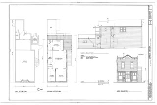
| HABS CAL,43-PALAL,1- (sheet 2 of 2) - Emperger Grocer, 532 Channing Avenue, Palo Alto, Santa Clara County, CA | ||||
|---|---|---|---|---|
| Photographer |
Related names:
|
|||
| Title |
HABS CAL,43-PALAL,1- (sheet 2 of 2) - Emperger Grocer, 532 Channing Avenue, Palo Alto, Santa Clara County, CA |
|||
| Depicted place | California; Santa Clara County; Palo Alto | |||
| Date | Documentation compiled after 1933 | |||
| Dimensions | 24 x 36 in. (D size) | |||
| Current location |
Library of Congress Prints and Photographs Division Washington, D.C. 20540 USA http://hdl.loc.gov/loc.pnp/pp.print |
|||
| Accession number |
HABS CAL,43-PALAL,1- (sheet 2 of 2) |
|||
| Credit line |
|
|||
| Notes |
|
|||
| Source | https://www.loc.gov/pictures/item/ca0954.sheet.00002a | |||
| Permission (Reusing this file) |
|
|||
| Other versions |
.png) .png) |
|||

| Object location | | View this and other nearby images on: OpenStreetMap |
|---|
File history
Click on a date/time to view the file as it appeared at that time.
| Date/Time | Thumbnail | Dimensions | User | Comment | |
|---|---|---|---|---|---|
| current | 11:03, 4 July 2014 |  | 14,426 × 9,632 (1.13 MB) | Fæ (talk | contribs) | GWToolset: Creating mediafile for Fæ. HABS 3 July 2014 (201:300) |
You cannot overwrite this file.
File usage on Commons
The following 2 pages use this file: