File:Electoral systems map.svg
Jump to navigation
Jump to search

Size of this PNG preview of this SVG file: 800 × 406 pixels. Other resolutions: 320 × 162 pixels | 640 × 325 pixels | 1,024 × 520 pixels | 1,280 × 650 pixels | 2,560 × 1,300 pixels | 2,754 × 1,398 pixels.
Original file (SVG file, nominally 2,754 × 1,398 pixels, file size: 1.05 MB)
Captions
Captions
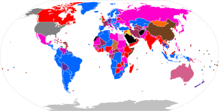
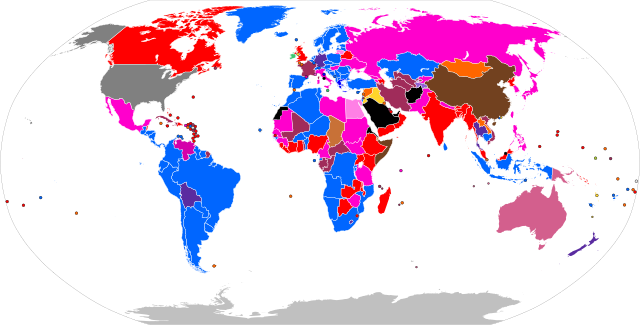
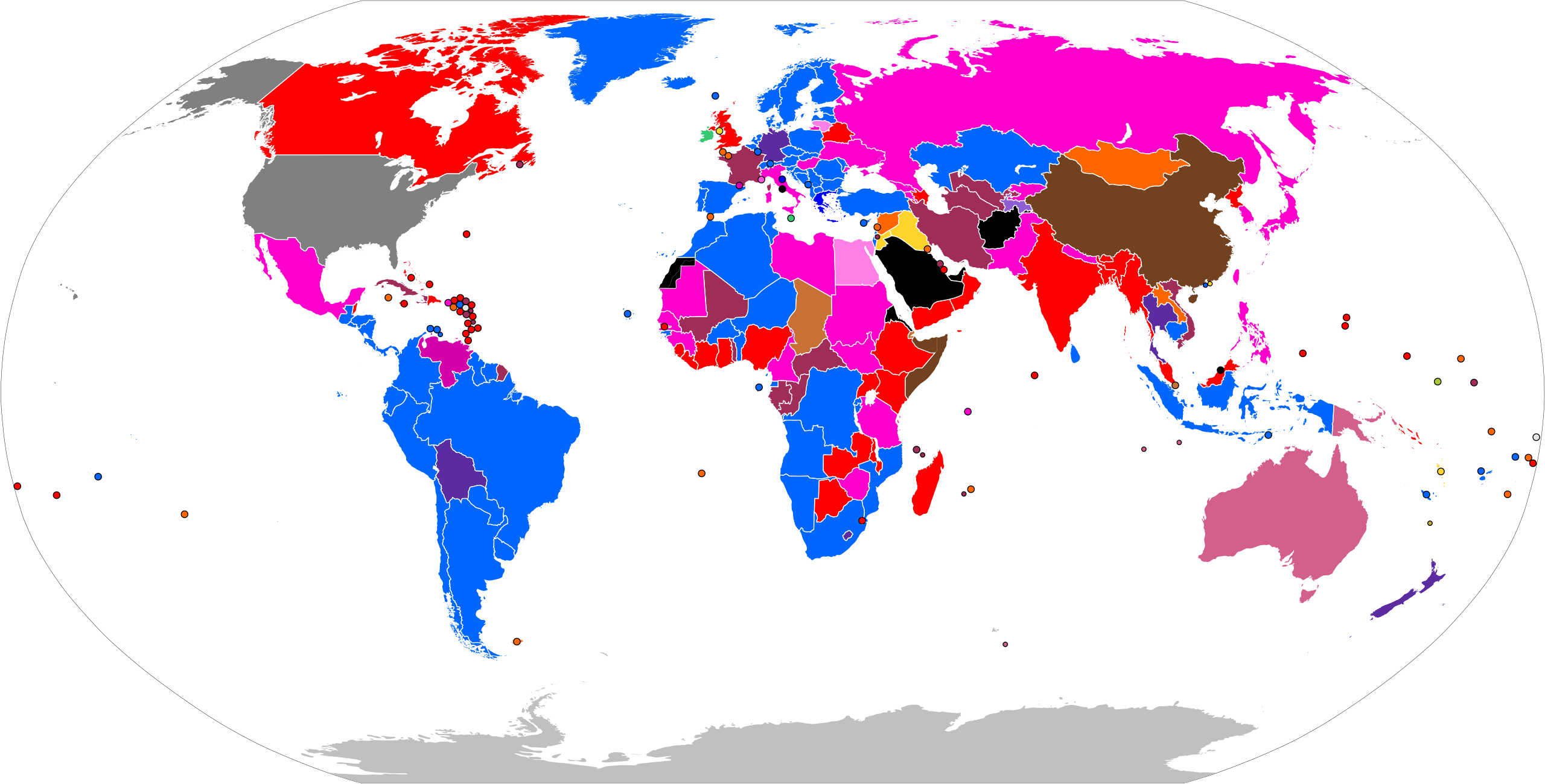
Map showing the electoral systems used to elect candidates to the lower house of national legislatures, as of August 2024.
Any autoconfirmed user can overwrite this file from the same source. Please ensure that overwrites comply with the guideline.
Legend
[edit]
Summary
[edit]
| Description |
English: See legend. |
| Date | |
| Source |
Derived from File:BlankMap-World.svg Information sources: en:Table of voting systems by nation, Table of Electoral Systems Worldwide etc. |
| Author |
File:BlankMap-World.svg: Canuckguy Derivative work: Altes |
| SVG development |
Licensing
[edit]
I, the copyright holder of this work, hereby publish it under the following license:
This file is licensed under the Creative Commons Attribution-Share Alike 3.0 Unported license.
- You are free:
- to share – to copy, distribute and transmit the work
- to remix – to adapt the work
- Under the following conditions:
- attribution – You must give appropriate credit, provide a link to the license, and indicate if changes were made. You may do so in any reasonable manner, but not in any way that suggests the licensor endorses you or your use.
- share alike – If you remix, transform, or build upon the material, you must distribute your contributions under the same or compatible license as the original.
File history
Click on a date/time to view the file as it appeared at that time.
| Date/Time | Thumbnail | Dimensions | User | Comment | |
|---|---|---|---|---|---|
| current | 20:15, 8 September 2024 | | 2,754 × 1,398 (1.05 MB) | Rankedchoicevoter (talk | contribs) | Gibraltar (LV), Isle of Man (BV), Norfolk Island (N/A) |
| 14:17, 3 September 2024 |  | 2,754 × 1,398 (1.05 MB) | Rankedchoicevoter (talk | contribs) | Ukraine | |
| 09:47, 3 September 2024 |  | 2,754 × 1,398 (1.05 MB) | Rankedchoicevoter (talk | contribs) | Monaco is not SNTV+PR, its BV+PR | |
| 12:44, 18 August 2024 |  | 2,754 × 1,398 (1.05 MB) | GlowstoneUnknown (talk | contribs) | changed colours, let me know if you'd make any changes, Rankedchoice. Monaco is more purple for contrast to pink of Italy. Fuchsia is warmer tone, also for contrast. TRS MJS implemented with lightened version of Pale Lilac + other discussed changes. | |
| 04:14, 12 August 2024 |  | 2,754 × 1,398 (1.05 MB) | GlowstoneUnknown (talk | contribs) | stroke width + colour changes per Talk: | |
| 13:07, 8 August 2024 |  | 2,754 × 1,398 (1.05 MB) | GlowstoneUnknown (talk | contribs) | Reverted to version as of 10:32, 8 August 2024 (UTC), let's talk about it first before changing these things | |
| 13:04, 8 August 2024 |  | 2,754 × 1,398 (1.05 MB) | Rankedchoicevoter (talk | contribs) | okay we we must have colombia as partially open list, at least let's flip the colors | |
| 12:53, 8 August 2024 |  | 2,754 × 1,398 (1.05 MB) | Rankedchoicevoter (talk | contribs) | Reverted to version as of 10:20, 8 August 2024 (UTC) | |
| 10:32, 8 August 2024 |  | 2,754 × 1,398 (1.05 MB) | GlowstoneUnknown (talk | contribs) | Reverted to version as of 14:37, 7 August 2024 (UTC) | |
| 10:20, 8 August 2024 |  | 2,754 × 1,398 (1.05 MB) | Rankedchoicevoter (talk | contribs) | I'll explain in talk page. New Zealand and the majority bonus/jackpot countries |
You cannot overwrite this file.
File usage on Commons
The following 11 pages use this file:
- User:Magog the Ogre/Political maps/2023 December 11-20
- User:Magog the Ogre/Political maps/2023 October 11-20
- User:Magog the Ogre/Political maps/2024 August 1-10
- User:Magog the Ogre/Political maps/2024 August 11-20
- User:Magog the Ogre/Political maps/2024 July 21-31
- User:Magog the Ogre/Political maps/2024 June 11-20
- User:Magog the Ogre/Political maps/2024 June 21-30
- User:Magog the Ogre/Political maps/2024 May 11-20
- User:Magog the Ogre/Political maps/2024 May 21-31
- User:Magog the Ogre/Political maps/2024 September 1-10
- File:Lower House FPTP.svg
File usage on other wikis
The following other wikis use this file:
- Usage on ar.wikipedia.org
- Usage on az.wikipedia.org
- Usage on de.wikipedia.org
- Usage on en.wikipedia.org
- Usage on eo.wikipedia.org
- Usage on es.wikipedia.org
- Usage on fa.wikipedia.org
- Usage on fi.wikipedia.org
- Usage on fr.wikipedia.org
- Usage on gl.wikipedia.org
- Usage on he.wikipedia.org
- Usage on hi.wikipedia.org
- Usage on hu.wikipedia.org
- Usage on id.wikipedia.org
- Usage on ka.wikipedia.org
- Usage on mk.wikipedia.org
- Usage on ms.wikipedia.org
- Usage on no.wikipedia.org
- Usage on pt.wikipedia.org
- Usage on ru.wikipedia.org
- Usage on sq.wikipedia.org
- Usage on sr.wikipedia.org
- Usage on th.wikipedia.org
- Usage on tr.wikipedia.org
- Usage on uk.wikipedia.org