File:Egypt Sudan claims.svg
Jump to navigation
Jump to search

Size of this PNG preview of this SVG file: 400 × 600 pixels. Other resolutions: 160 × 240 pixels | 320 × 480 pixels | 512 × 768 pixels | 682 × 1,024 pixels | 1,365 × 2,048 pixels.
Original file (SVG file, nominally 512 × 768 pixels, file size: 461 KB)
Captions
Captions
Add a one-line explanation of what this file represents
Summary
[edit]| Description |
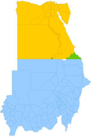
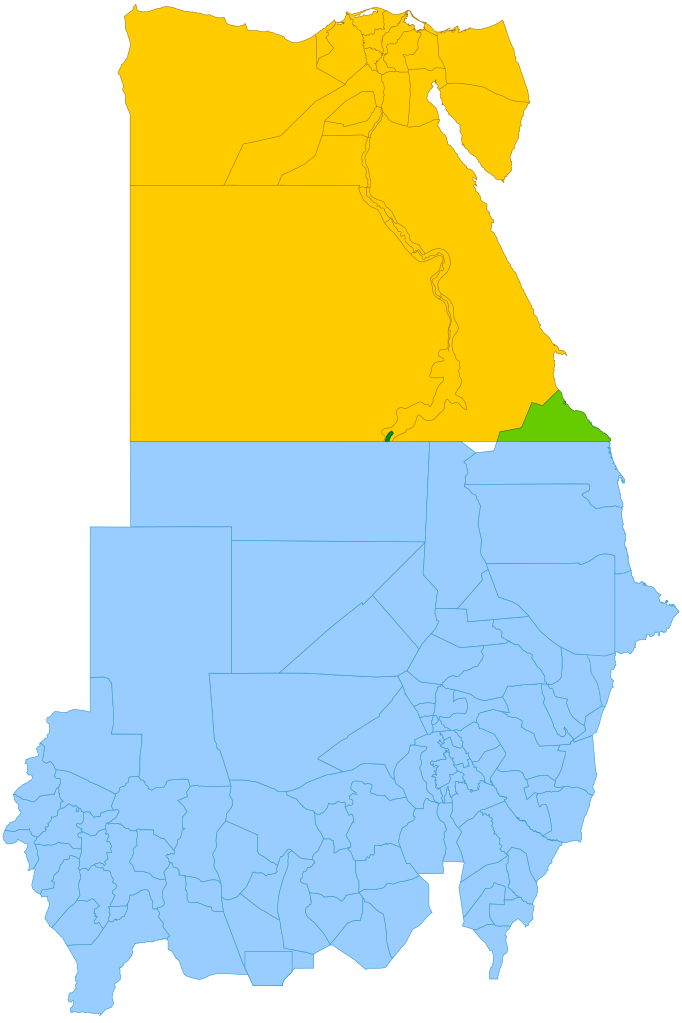
English: Simplified map showing Egypt's claim (yellow and green), Sudan's claim (blue and green), the Hala'ib Triangle (light green), Wadi Halfa Salient (dark green) and Bir Tawil (white). |
| Date | (UTC) |
| Source |
This file was derived from: |
| Author | |
| SVG development | This map was created with a text editor. |

Licensing
[edit]
This file is licensed under the Creative Commons Attribution-Share Alike 3.0 Unported license.
- You are free:
- to share – to copy, distribute and transmit the work
- to remix – to adapt the work
- Under the following conditions:
- attribution – You must give appropriate credit, provide a link to the license, and indicate if changes were made. You may do so in any reasonable manner, but not in any way that suggests the licensor endorses you or your use.
- share alike – If you remix, transform, or build upon the material, you must distribute your contributions under the same or compatible license as the original.
Original upload log
[edit]
This image is a derivative work of the following images:
- File:Political_Regions_of_Sudan,_July_2010.svg licensed with Cc-zero
- File:Egypt_location_map.svg licensed with Cc-by-sa-3.0, GFDL
- 2011-04-17T16:03:10Z NordNordWest 1055x973 (359140 Bytes) upd
- 2010-03-07T17:03:18Z NordNordWest 1055x973 (566369 Bytes) resize
- 2009-09-03T10:48:31Z NordNordWest 1055x956 (565065 Bytes)
- 2009-05-23T19:10:12Z NordNordWest 1056x959 (570357 Bytes) corr
- 2008-08-10T11:12:09Z NordNordWest 1056x957 (503154 Bytes) {{Information |Description= {{de|Positionskarte von [[:de:Ägypten|Ägypten]]}} Quadratische Plattkarte, N-S-Streckung 110 %. Geographische Begrenzung der Karte: * N: 32.1° N * S: 21.3° N * W: 24.2° O * O: 37.3° O {{en|Lo
Uploaded with derivativeFX
File history
Click on a date/time to view the file as it appeared at that time.
| Date/Time | Thumbnail | Dimensions | User | Comment | |
|---|---|---|---|---|---|
| current | 11:15, 13 October 2021 | | 512 × 768 (461 KB) | Cmglee (talk | contribs) | Shade Wadi Halfa Salient as per http://commons.wikimedia.org/wiki/File_talk:Egypt_Sudan_claims.svg#Wadi_Halfa_Salient |
| 12:58, 16 February 2019 |  | 512 × 768 (461 KB) | AntiCompositeNumber (talk | contribs) | Avoid messing with file structure so much when <!-- --> will work | |
| 12:51, 16 February 2019 |  | 512 × 768 (465 KB) | AntiCompositeNumber (talk | contribs) | Remove striping that makes image harder to see per request at e n:Wikipedia:Graphics_Lab/Map_workshop | |
| 17:47, 21 June 2018 |  | 512 × 768 (461 KB) | Cmglee (talk | contribs) | Add white background as per File_talk:Egypt_Sudan_claims.svg#Bir_Tawil_area | |
| 17:44, 8 November 2015 |  | 512 × 768 (460 KB) | McGeddon (talk | contribs) | Remove unnecessary captions, image is colour-coded. | |
| 21:28, 11 January 2013 |  | 512 × 768 (461 KB) | Cmglee (talk | contribs) | Update colours and label alignment. | |
| 21:19, 11 January 2013 |  | 512 × 768 (461 KB) | Cmglee (talk | contribs) | == {{int:filedesc}} == {{Information |Description={{en|Map showing political regions of Sudan as of July 2006.}} {{legend|#8cc63f|Darfur}} {{legend|#fb6282|Nuba Mountains and Blue Nile}} {{legend|#f7931d|North Sudan}} {{legend|#800080|Eastern Front, ar... |
You cannot overwrite this file.
File usage on Commons
The following 4 pages use this file:
File usage on other wikis
The following other wikis use this file:
- Usage on ar.wikipedia.org
- Usage on arz.wikipedia.org
- Usage on ast.wikipedia.org
- Usage on az.wikipedia.org
- Usage on be.wikipedia.org
- Usage on ca.wikipedia.org
- Usage on da.wikipedia.org
- Usage on de.wikipedia.org
- Usage on de.wikivoyage.org
- Usage on el.wikipedia.org
- Usage on en.wikipedia.org
- Usage on en.wikivoyage.org
- Usage on eo.wikipedia.org
- Usage on es.wikipedia.org
- Usage on fi.wikipedia.org
- Usage on fr.wikipedia.org
- Usage on gl.wikipedia.org
- Usage on id.wikipedia.org
- Usage on it.wikipedia.org
- Usage on ja.wikipedia.org
- Usage on ja.wikivoyage.org
- Usage on jv.wikipedia.org
- Usage on ko.wikipedia.org
- Usage on ms.wikipedia.org
- Usage on nl.wikipedia.org
- Usage on no.wikipedia.org
- Usage on pt.wikipedia.org
- Usage on ro.wikipedia.org
- Usage on so.wikipedia.org
- Usage on sr.wikipedia.org
- Usage on uk.wikipedia.org
View more global usage of this file.