File:Easington Cliffs - geograph.org.uk - 1263118.jpg
Jump to navigation
Jump to search
No higher resolution available.
Easington_Cliffs_-_geograph.org.uk_-_1263118.jpg (640 × 428 pixels, file size: 93 KB, MIME type: image/jpeg)
Captions
Captions
Add a one-line explanation of what this file represents
Summary
[edit]
| Description |
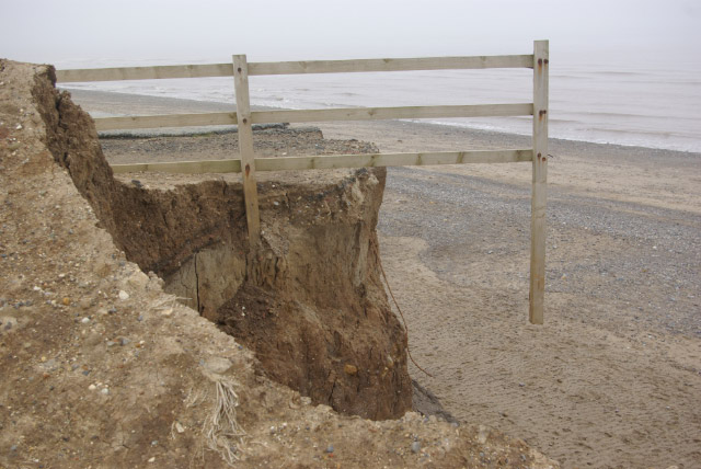
English: Easington Cliffs, Easington, East Riding of Yorkshire, England. The Holderness Coast between Spurn and Bridlington has long been notorious for the rate of erosion. The soft boulder clay cliffs are undermined by wave action and collapse; the debris is then washed away forming a new cliff which is itself undermined and the cycle repeats. This fence, sticking out into thin air, looks bizarre, but erosion has claimed much bigger prizes including roads and houses and - historically - whole villages. |
| Date | |
| Source | From geograph.org.uk |
| Author | Stephen McKay |
| Permission (Reusing this file) |
Creative Commons Attribution Share-alike license 2.0 |
| Attribution (required by the license) | Stephen McKay / Easington Cliffs / |
| Camera location | | View this and other nearby images on: OpenStreetMap |
|---|
_heading:0.00&language=en)
| Object location | | View this and other nearby images on: OpenStreetMap |
|---|
_heading:0.00&language=en)
Licensing
[edit]

|
This image was taken from the Geograph project collection. See this photograph's page on the Geograph website for the photographer's contact details. The copyright on this image is owned by Stephen McKay and is licensed for reuse under the Creative Commons Attribution-ShareAlike 2.0 license.
|
This file is licensed under the Creative Commons Attribution-Share Alike 2.0 Generic license.
Attribution: Stephen McKay
- You are free:
- to share – to copy, distribute and transmit the work
- to remix – to adapt the work
- Under the following conditions:
- attribution – You must give appropriate credit, provide a link to the license, and indicate if changes were made. You may do so in any reasonable manner, but not in any way that suggests the licensor endorses you or your use.
- share alike – If you remix, transform, or build upon the material, you must distribute your contributions under the same or compatible license as the original.
File history
Click on a date/time to view the file as it appeared at that time.
| Date/Time | Thumbnail | Dimensions | User | Comment | |
|---|---|---|---|---|---|
| current | 23:11, 26 February 2011 | | 640 × 428 (93 KB) | GeographBot (talk | contribs) | == {{int:filedesc}} == {{Information |description={{en|1=Easington Cliffs The Holderness Coast between Spurn and Bridlington has long been notorious for the rate of erosion. The soft boulder clay cliffs are undermined by wave action and collapse; the debr |
You cannot overwrite this file.
File usage on Commons
There are no pages that use this file.
Metadata
Categories:
- Coast of Easington, East Riding of Yorkshire
- Cliffs of the East Riding of Yorkshire
- Beaches of the East Riding of Yorkshire
- Coastal erosion in the East Riding of Yorkshire
- Fences in the East Riding of Yorkshire
- Low tide in the East Riding of Yorkshire
- April 2009 in the East Riding of Yorkshire
- Boulder clay cliffs in the United Kingdom