File:Earth from Space- Madeira ESA499422.tiff

Original file (9,720 × 7,415 pixels, file size: 206.23 MB, MIME type: image/tiff)
Captions
Captions
Summary
[edit]| Warning | The original file is very high-resolution. It might not load properly or could cause your browser to freeze when opened at full size. |
|---|
| Description |
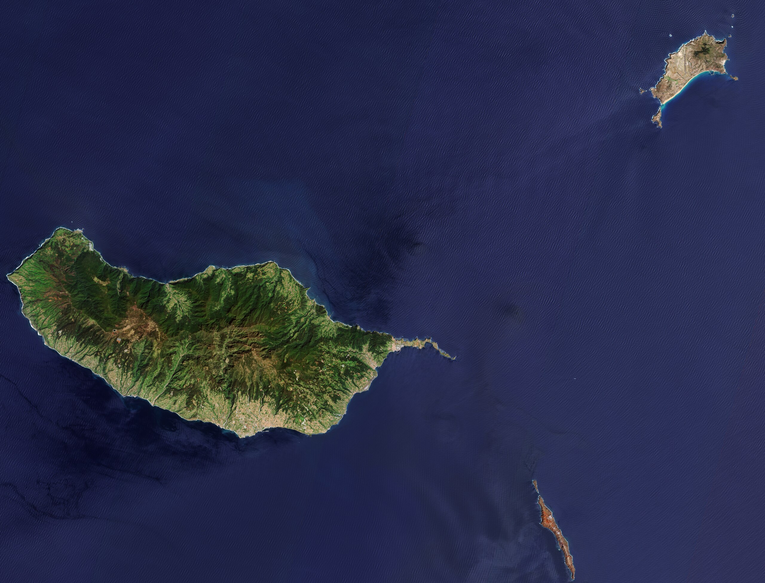
English: The Copernicus Sentinel-2 mission captured a rare, cloud-free image over the Portuguese archipelago of Madeira in the North Atlantic Ocean. Zoom in to explore this image at its full 10 m resolution or click on the circles to learn more. Lying off the northwest coast of Africa, the archipelago is an autonomous region of Portugal and comprises two inhabited islands, Madeira, the largest, and Porto Santo (top right), and two uninhabited groups, the Desertas (partially visible at the bottom) and the Selvagens (not pictured). The islands of Madeira are volcanic in origin: they are the tops of mountains that rise from the ocean floor deep below. The Portuguese explorers named them Madeira, which is Portuguese for wood, inspired by the dense forests that covered the islands when they arrived. The lush main island of Madeira is famous for its rugged, green landscape and is home to unique endemic flora and fauna. To protect this natural environment, two thirds of the island are designated as national park. The Madeira Natural Park includes the Laurisilva of Madeira, a Unesco World Heritage site and the largest surviving area of primary laurel forest. This type of vegetation is now confined to the Macaronesian Islands ̶ the islands of Madeira, the Azores, the Canary Islands and Cabo Verde. Funchal, Madeira’s capital, can be seen as a large, light-brown area on the island’s southeast coast, on the lower slopes of mountains that reach 1200 m. The runway of Madeira’s airport is visible on the east coast. The narrow Desertas Islands at the bottom are also designated as a natural reserve. Uninhabited by humans due to scarce and poor-quality water, Desertas are home to numerous species of birds, as well as the protected Mediterranean monk seal. The islands are relatively barren with their reddish and brown ground, a reminder of their volcanic origin. Porto Santo, at the top, features white, sandy beaches along its south coast. Here, the island’s main town, Vila de Porto Santo, can also be spotted, with its airport visible just to the north. At each end of the island are hills. At 515 m, Facho Peak, on the east, is the highest. |
| Date | 5 July 2024 (upload date) |
| Source | Earth from Space: Madeira |
| Author | European Space Agency |
| Other versions |
|
| Activity | Observing the Earth |
| Mission | Sentinel-2 |
| Set | Earth from Space image collection |
| System | Copernicus |

Licensing
[edit]
|
This image contains data from a satellite in the Copernicus Programme, such as Sentinel-1, Sentinel-2 or Sentinel-3. Attribution is required when using this image.
Attribution: Contains modified Copernicus Sentinel data 2024
The use of Copernicus Sentinel Data is regulated under EU law (Commission Delegated Regulation (EU) No 1159/2013 and Regulation (EU) No 377/2014). Relevant excerpts:
Free access shall be given to GMES dedicated data [...] made available through GMES dissemination platforms [...].
Access to GMES dedicated data [...] shall be given for the purpose of the following use in so far as it is lawful:
GMES dedicated data [...] may be used worldwide without limitations in time.
GMES dedicated data and GMES service information are provided to users without any express or implied warranty, including as regards quality and suitability for any purpose. |
This media was created by the European Space Agency (ESA).
Where expressly so stated, images or videos are covered by the Creative Commons Attribution-ShareAlike 3.0 IGO (CC BY-SA 3.0 IGO) licence, ESA being an Intergovernmental Organisation (IGO), as defined by the CC BY-SA 3.0 IGO licence. The user is allowed under the terms and conditions of the CC BY-SA 3.0 IGO license to Reproduce, Distribute and Publicly Perform the ESA images and videos released under CC BY-SA 3.0 IGO licence and the Adaptations thereof, without further explicit permission being necessary, for as long as the user complies with the conditions and restrictions set forth in the CC BY-SA 3.0 IGO licence, these including that:
See the ESA Creative Commons copyright notice for complete information, and this article for additional details.
|
 | |
This file is licensed under the Creative Commons Attribution-ShareAlike 3.0 IGO license. Attribution: ESA, CC BY-SA IGO 3.0
| ||
File history
Click on a date/time to view the file as it appeared at that time.
| Date/Time | Thumbnail | Dimensions | User | Comment | |
|---|---|---|---|---|---|
| current | 06:03, 6 July 2024 |  | 9,720 × 7,415 (206.23 MB) | OptimusPrimeBot (talk | contribs) | #Spacemedia - Upload of https://esamultimedia.esa.int/images/EarthObservation/madeira_S2_20240412_10m_CF_v2.tif via Commons:Spacemedia |
You cannot overwrite this file.
File usage on Commons
The following page uses this file: