File:Disturnell & Schroeter Map Illustrating the Disputed Boundary Between the United States and Mexico 1853 UTA.jpg
Jump to navigation
Jump to search

Size of this preview: 800 × 468 pixels. Other resolutions: 320 × 187 pixels | 640 × 375 pixels | 1,024 × 599 pixels | 1,280 × 749 pixels | 2,560 × 1,498 pixels | 4,188 × 2,451 pixels.
Original file (4,188 × 2,451 pixels, file size: 1.24 MB, MIME type: image/jpeg)
Captions
Captions
Add a one-line explanation of what this file represents
Summary
[edit]
| Title |
English: Map illustrating the Disputed Boundary between the United States and Mexico |
||||||||||||||||||||||||||
| Description |
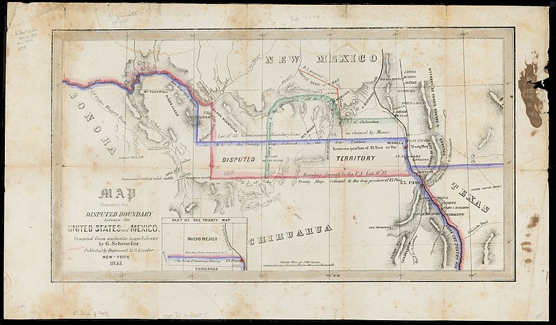
English: Soon after the U.S. and Mexican Boundary Commissions began their surveys in 1849, they noted glaring errors on the 1847 map that had been used to negotiate the Treaty of Guadalupe Hidalgo. The town of El Paso, and thus the boundary itself, had been situated too far to the north on the map, resulting in disagreements between the United States and Mexican governments over exactly where the boundary should be. The New York publisher of the original treaty map, John Disturnell, later issued this map to correct the earlier errors and to illustrate the disputed boundary lines that had resulted (the red for the U.S. claim and the blue for Mexico's). Also, as shown, Americans had learned that even with the corrections in latitude, one of the best routes to California – Cooke's Wagon Road – actually lay south of the new border, and a large lobby of U.S. citizens wanted the land to construct a railroad from El Paso to the Pacific. Given the Mexican government's need for cash, on December 30, 1853, U.S. and Mexican diplomats signed the Gadsden Purchase treaty, whereby the United States paid Mexico $10 million for 29,142,400 acres of a wedge of land within the present states of New Mexico and Arizona. |
||||||||||||||||||||||||||
| Date | |||||||||||||||||||||||||||
| Source | UTA Libraries Cartographic Connections: map / text | ||||||||||||||||||||||||||
| Creator |
|
||||||||||||||||||||||||||
| Credit line |
English: UTA Libraries Special Collections |
||||||||||||||||||||||||||
| Geotemporal data | |||||||||||||||||||||||||||
| Map location |
United States of America Mexico |
||||||||||||||||||||||||||
| Georeferencing | If inappropriate please set warp_status = skip to hide. | ||||||||||||||||||||||||||
| Bibliographic data | |||||||||||||||||||||||||||
| Place of publication | New York City | ||||||||||||||||||||||||||
| Printed by |
|
||||||||||||||||||||||||||
| Archival data | |||||||||||||||||||||||||||
| Collection |
|
||||||||||||||||||||||||||
| Dimensions | height: 22.5 cm (8.8 in); width: 40 cm (15.7 in) | ||||||||||||||||||||||||||
| Medium | colored lithograph | ||||||||||||||||||||||||||
| artwork-references | Wheat Mapping the Trans-Mississippi West, 3, no. 779 , pp. 236, 325 | ||||||||||||||||||||||||||
Licensing
[edit]

|
This file was provided to Wikimedia Commons by the University of Texas at Arlington Libraries as part of a cooperation project. The University of Texas at Arlington Libraries is part of the University of Texas at Arlington, a public research university located in Arlington, Texas.
|
|
The author died in 1877, so this work is in the public domain in its country of origin and other countries and areas where the copyright term is the author's life plus 100 years or fewer. This work is in the public domain in the United States because it was published (or registered with the U.S. Copyright Office) before January 1, 1929. | |
| This file has been identified as being free of known restrictions under copyright law, including all related and neighboring rights. | |
File history
Click on a date/time to view the file as it appeared at that time.
| Date/Time | Thumbnail | Dimensions | User | Comment | |
|---|---|---|---|---|---|
| current | 18:50, 12 March 2022 | | 4,188 × 2,451 (1.24 MB) | Michael Barera (talk | contribs) | == {{int:filedesc}} == {{Map |title = {{en|'''''Map illustrating the Disputed Boundary between the United States and Mexico'''''}} |description = {{en|Soon after the U.S. and Mexican Boundary Commissions began their surveys in 1849, they noted glaring errors on the 1847 map that had been used to negotiate the Treaty of Guadalupe Hidalgo. The town of El Paso, and thus the boundary itself, had been situated too far to the north on the map, resulting in disagreements between... |
You cannot overwrite this file.
File usage on Commons
The following page uses this file:
File usage on other wikis
The following other wikis use this file:
- Usage on de.wikipedia.org
- Usage on es.wikipedia.org
- Usage on fr.wikipedia.org
- Usage on hu.wikipedia.org
- Usage on ko.wikipedia.org