File:Districts of Tainan-Taiwan.svg
Jump to navigation
Jump to search

Size of this PNG preview of this SVG file: 566 × 599 pixels. Other resolutions: 227 × 240 pixels | 453 × 480 pixels | 725 × 768 pixels | 967 × 1,024 pixels | 1,934 × 2,048 pixels | 610 × 646 pixels.
Original file (SVG file, nominally 610 × 646 pixels, file size: 7 KB)
Captions
Captions
Add a one-line explanation of what this file represents
Summary
[edit]| Description |
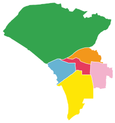
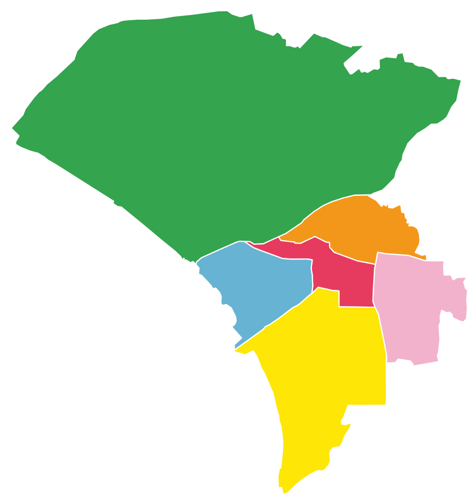
Deutsch: Bezirke der Innenstadt von Taiwan (Stadtgebiet von Tainan vor dem Jahr 2010):
Bezirk Anping
Bezirk Annan
Ostbezirk
West-Zentralbezirk
Südbezirk
Nordbezirk 中文(繁體):台南市分區地圖:
安平區
安南區
東區
中西區
南區
北區 閩南語 / Bân-lâm-gú:Tâi-lâm-chhī hun-khu tē-tô͘:
An-pêng-khu
An-lâm-khu
Tang-khu
Tiong-se-khu
Lâm-khu
Pak-khu English: Districts of Tainan City (downtown, i.e. Taiwan City before 2010):
Anping District
Annan District
East District
West Central District
South District
North District |
|||
| Date | ||||
| Source | Own work based on: OpenStreetMap | |||
| Author | Furfur | |||
| Permission (Reusing this file) |
I, the copyright holder of this work, hereby publish it under the following license: This file is licensed under the Creative Commons Attribution-Share Alike 2.5 Generic license.
|
|||
| Other versions |
|
|||
| SVG development | This map was created with Adobe Illustrator. |


File history
Click on a date/time to view the file as it appeared at that time.
| Date/Time | Thumbnail | Dimensions | User | Comment | |
|---|---|---|---|---|---|
| current | 14:55, 15 December 2018 | | 610 × 646 (7 KB) | Furfur (talk | contribs) | Rand |
| 14:52, 15 December 2018 |  | 619 × 676 (7 KB) | Furfur (talk | contribs) | {{Information |Description={{de|1=Bezirke der Innenstadt von Taiwan (Stadtgebiet von Tainan vor dem Jahr 2010): {{legend|#67B3D3|Bezirk Anping}} {{legend|#33A34D|Bezirk Annan District}} {{legend|#FBB4CE|Ostbezirk}} {{legend|#F8355C|West-Zentralbezirk}} {{legend|#FFE600|Südbezirk}} {{legend|#FF9900|Nordbezirk}}}} {{zh-hant|1=台南市分區地圖: {{legend|#67B3D3|安平區}} {{legend|#33A34D|安南區}} {{legend|#FBB4CE|東區}} {{legend|#F8355C|中西區}} {{legend|#FFE600|南區}} {{legend|#FF9900|北區}}}} {{nan|1=Tâi-lâm-chhī hun-... |
You cannot overwrite this file.
File usage on Commons
The following page uses this file:
File usage on other wikis
The following other wikis use this file:
- Usage on de.wikipedia.org