File:Dique Nezahualcóyotl primer mapa de Tenochtitlan.png
Jump to navigation
Jump to search

Size of this preview: 800 × 239 pixels. Other resolutions: 320 × 96 pixels | 640 × 191 pixels | 1,024 × 306 pixels | 1,280 × 382 pixels | 4,100 × 1,224 pixels.
Original file (4,100 × 1,224 pixels, file size: 12.83 MB, MIME type: image/png)
Captions
Captions
Add a one-line explanation of what this file represents
Summary
[edit]
| Description |
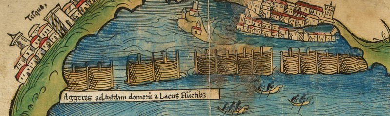
English: Detail of Nezahualcóyotl's dam to control water levels around Tenochtitlan |
| Date | circa 1520 |
| Source | Primer Mapa de la Ciudad de México |
| Author | Hernán Cortes |
Licensing
[edit]
|
This work is in the public domain in its country of origin and other countries and areas where the copyright term is the author's life plus 70 years or fewer. | |
| This file has been identified as being free of known restrictions under copyright law, including all related and neighboring rights. | |
File history
Click on a date/time to view the file as it appeared at that time.
| Date/Time | Thumbnail | Dimensions | User | Comment | |
|---|---|---|---|---|---|
| current | 06:04, 3 January 2021 | 4,100 × 1,224 (12.83 MB) | ErickTErick (talk | contribs) | Higher resolution | |
| 08:44, 21 March 2015 | 770 × 229 (327 KB) | PauloCalvo (talk | contribs) | User created page with UploadWizard |
You cannot overwrite this file.
File usage on Commons
There are no pages that use this file.
File usage on other wikis
The following other wikis use this file:
- Usage on ast.wikipedia.org
- Usage on en.wikipedia.org
- Usage on es.wikipedia.org
- Usage on fr.wikipedia.org