File:Diag ombro Angers (49).pdf
Jump to navigation
Jump to search

Size of this JPG preview of this PDF file: 423 × 599 pixels. Other resolutions: 169 × 240 pixels | 339 × 480 pixels | 542 × 768 pixels | 1,239 × 1,754 pixels.
Original file (1,239 × 1,754 pixels, file size: 31 KB, MIME type: application/pdf)
Captions
Captions
Add a one-line explanation of what this file represents
Summary
[edit]| Description |
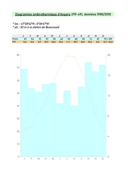
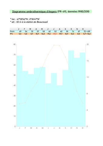
Français : La station relevés de Beaucouzé a la particularité de ne pas se situer en site aéroportuaire, souvent choisis pour les mesures météo. (l'aéroport d'Angers se trouve lui à 25 km au nord-est du centre ville en direction de La Flèche, sur la commune de Marcé) |
| Date | |
| Source | Own work |
| Author | Dacia 1410 Sport |
Licensing
[edit]I, the copyright holder of this work, hereby publish it under the following license:
This file is licensed under the Creative Commons Attribution-Share Alike 4.0 International license.
- You are free:
- to share – to copy, distribute and transmit the work
- to remix – to adapt the work
- Under the following conditions:
- attribution – You must give appropriate credit, provide a link to the license, and indicate if changes were made. You may do so in any reasonable manner, but not in any way that suggests the licensor endorses you or your use.
- share alike – If you remix, transform, or build upon the material, you must distribute your contributions under the same or compatible license as the original.
File history
Click on a date/time to view the file as it appeared at that time.
| Date/Time | Thumbnail | Dimensions | User | Comment | |
|---|---|---|---|---|---|
| current | 11:45, 12 March 2023 |  | 1,239 × 1,754 (31 KB) | Dacia 1410 Sport (talk | contribs) | Uploaded own work with UploadWizard |
You cannot overwrite this file.
File usage on Commons
There are no pages that use this file.