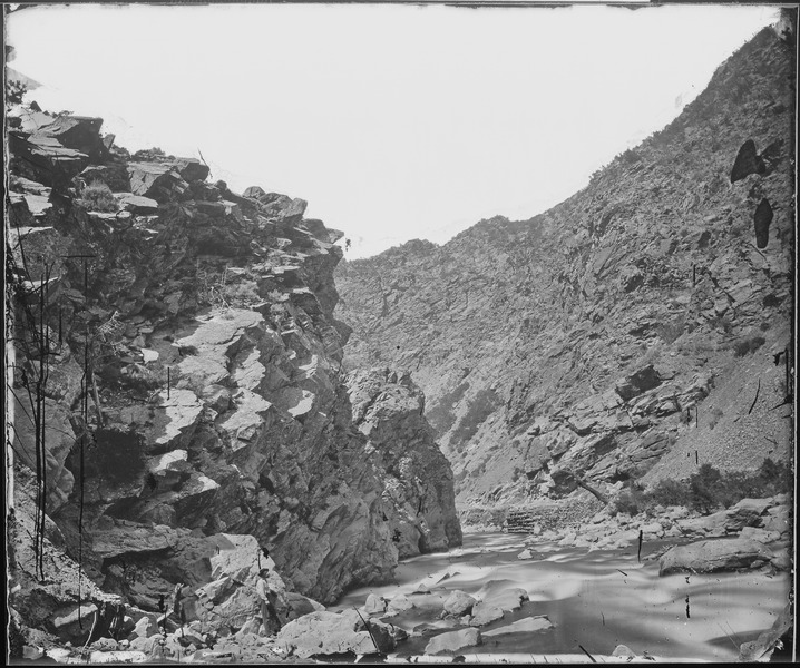
File:Devil's Gate. Weber Canyon, Utah - NARA - 519459.tif

Original file (3,000 × 2,505 pixels, file size: 7.17 MB, MIME type: image/tiff)
Captions
Captions
Summary
[edit]| Devil's Gate. Weber Canyon, Utah
( |
|||||||||||||||||||||||||||
|---|---|---|---|---|---|---|---|---|---|---|---|---|---|---|---|---|---|---|---|---|---|---|---|---|---|---|---|
| Author |
creator QS:P170,Q1371063 (NARA record: 1733522) |
||||||||||||||||||||||||||
| Record creator InfoField | War Department. Office of the Chief of Engineers. U.S. Geological Exploration of the Fortieth Parallel. (1867 - 1881) | ||||||||||||||||||||||||||
| Title |
Devil's Gate. Weber Canyon, Utah |
||||||||||||||||||||||||||
| Date |
circa 1869 date QS:P571,+1869-00-00T00:00:00Z/9,P1480,Q5727902 |
||||||||||||||||||||||||||
| Collection |
institution QS:P195,Q38945047 Still Picture Records Section, Special Media Archives Services Division (NWCS-S) |
||||||||||||||||||||||||||
| Record ID InfoField |
|
||||||||||||||||||||||||||
| Source | U.S. National Archives and Records Administration | ||||||||||||||||||||||||||
| Other versions |
Please do not overwrite this file: any restoration work should be uploaded with a new name and linked in this page's "other versions=" parameter, so that this file represents the exact file found in the NARA catalog record to which it links. The metadata on this page was imported directly from NARA's catalog record; additional descriptive text may be added by Wikimedians to the template below with the "description=" parameter, but please do not modify the other fields.
|
||||||||||||||||||||||||||
Licensing
[edit]
|
This file was provided to Wikimedia Commons by the National Archives and Records Administration as part of a cooperation project. The National Archives and Records Administration provides images depicting American and global history which are public domain or licensed under a free license.
العربية ∙ български ∙ Deutsch ∙ English ∙ Esperanto ∙ español ∙ français ∙ Ido ∙ 日本語 ∙ 한국어 ∙ македонски ∙ മലയാളം ∙ Nederlands ∙ português ∙ русский ∙ Türkçe ∙ українська ∙ 简体中文 ∙ 繁體中文 ∙ 正體中文(臺灣) ∙ +/− |
| Public domainPublic domainfalsefalse |
This work is in the public domain in the United States because it is a work prepared by an officer or employee of the United States Government as part of that person’s official duties under the terms of Title 17, Chapter 1, Section 105 of the US Code.
Note: This only applies to original works of the Federal Government and not to the work of any individual U.S. state, territory, commonwealth, county, municipality, or any other subdivision. This template also does not apply to postage stamp designs published by the United States Postal Service since 1978. (See § 313.6(C)(1) of Compendium of U.S. Copyright Office Practices). It also does not apply to certain US coins; see The US Mint Terms of Use.
|
 | |
| This file has been identified as being free of known restrictions under copyright law, including all related and neighboring rights. | ||
https://creativecommons.org/publicdomain/mark/1.0/PDMCreative Commons Public Domain Mark 1.0falsefalse
File history
Click on a date/time to view the file as it appeared at that time.
| Date/Time | Thumbnail | Dimensions | User | Comment | |
|---|---|---|---|---|---|
| current | 11:19, 4 October 2011 |  | 3,000 × 2,505 (7.17 MB) | US National Archives bot (talk | contribs) | == {{int:filedesc}} == {{NARA-image-full |Title=Devil's Gate. Weber Canyon, Utah |Scope and content= |General notes= |ARC=519459 |Local identifier=77-KN-29 |Creator=War Department. Office of the Chief of Engineers. U.S. Geological Exploration of the Fort |
You cannot overwrite this file.
File usage on Commons
The following 2 pages use this file:
Metadata
This file contains additional information such as Exif metadata which may have been added by the digital camera, scanner, or software program used to create or digitize it. If the file has been modified from its original state, some details such as the timestamp may not fully reflect those of the original file. The timestamp is only as accurate as the clock in the camera, and it may be completely wrong.
| Image title | Landscape |
|---|---|
| Author | NARA |
| Width | 3,000 px |
| Height | 2,505 px |
| Bits per component | 8 |
| Compression scheme | Uncompressed |
| Pixel composition | Black and white (Black is 0) |
| Image data location | 282 |
| Number of components | 1 |
| Number of rows per strip | 2,505 |
| Bytes per compressed strip | 7,515,000 |
| Horizontal resolution | 300 dpi |
| Vertical resolution | 300 dpi |
| File change date and time | 14:02, 26 February 1998 |
Structured data
Items portrayed in this file
depicts
some value
Devil's Gate. Weber Canyon, Utah (English)
- Images from the National Archives and Records Administration
- High-resolution TIFF images from the National Archives and Records Administration
- Artworks without Wikidata item
- US National Archives series: Geological Exploration of the Fortieth Parallel-The King Survey, compiled 1867 - 1872
- Media contributed by the National Archives and Records Administration
- CC-PD-Mark
- PD US Government


