File:Detail view of east elevation to show north tower and entrance - Texas and Pacific Railway Depot, Seventh Street, Natchitoches, Natchitoches Parish, LA HABS LA-1296-3.tif
Jump to navigation
Jump to search

Size of this JPG preview of this TIF file: 437 × 599 pixels. Other resolutions: 175 × 240 pixels | 350 × 480 pixels | 560 × 768 pixels | 746 × 1,024 pixels | 1,493 × 2,048 pixels | 3,786 × 5,193 pixels.
Original file (3,786 × 5,193 pixels, file size: 18.75 MB, MIME type: image/tiff)
Captions
Captions
Add a one-line explanation of what this file represents
Summary
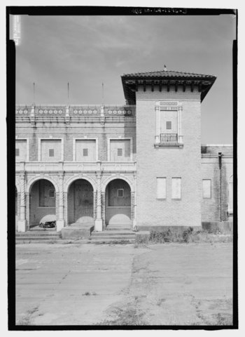
[edit]| Detail view of east elevation to show north tower and entrance - Texas and Pacific Railway Depot, Seventh Street, Natchitoches, Natchitoches Parish, LA | ||||
|---|---|---|---|---|
| Title |
Detail view of east elevation to show north tower and entrance - Texas and Pacific Railway Depot, Seventh Street, Natchitoches, Natchitoches Parish, LA |
|||
| Description |
English: Texas and Pacific Railroad Depot — located on Sixth Street in Natchitoches, Louisiana.
|
|||
| Depicted place | Louisiana; Natchitoches Parish; Natchitoches | |||
| Date | Documentation compiled after 1933 | |||
| Dimensions | 5 x 7 in. | |||
| Current location |
Library of Congress Prints and Photographs Division Washington, D.C. 20540 USA http://hdl.loc.gov/loc.pnp/pp.print |
|||
| Accession number |
HABS LA-1296-3 |
|||
| Credit line |
|
|||
| Notes |
|
|||
| References |
|
|||
| Source | https://www.loc.gov/pictures/item/la0418.photos.210229p | |||
| Permission (Reusing this file) |
|
|||

| Object location | | View this and other nearby images on: OpenStreetMap |
|---|
File history
Click on a date/time to view the file as it appeared at that time.
| Date/Time | Thumbnail | Dimensions | User | Comment | |
|---|---|---|---|---|---|
| current | 00:27, 18 July 2014 |  | 3,786 × 5,193 (18.75 MB) | Fæ (talk | contribs) | GWToolset: Creating mediafile for Fæ. HABS 17 July 2014 (1401:1600) |
You cannot overwrite this file.
File usage on Commons
The following page uses this file: