File:Map administrative divisions of the First French Empire 1812-en.svg

Original file (SVG file, nominally 2,052 × 1,728 pixels, file size: 4.14 MB)
Captions
Captions
Summary
[edit]| Description |
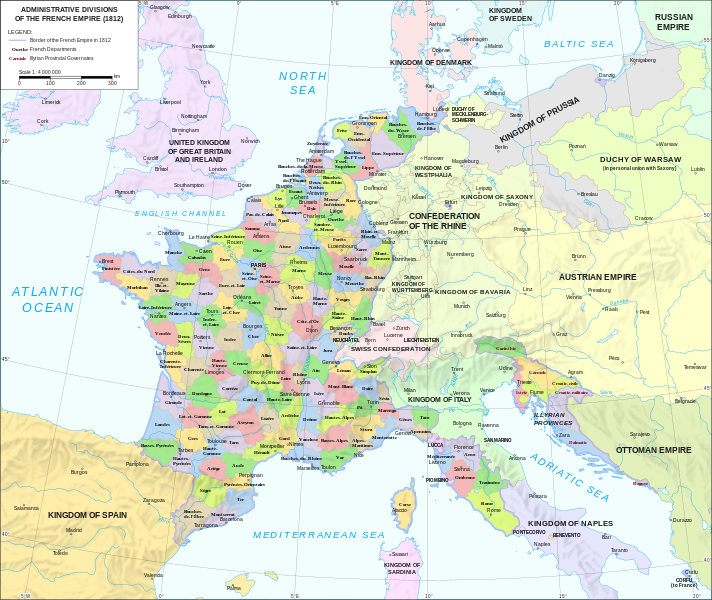
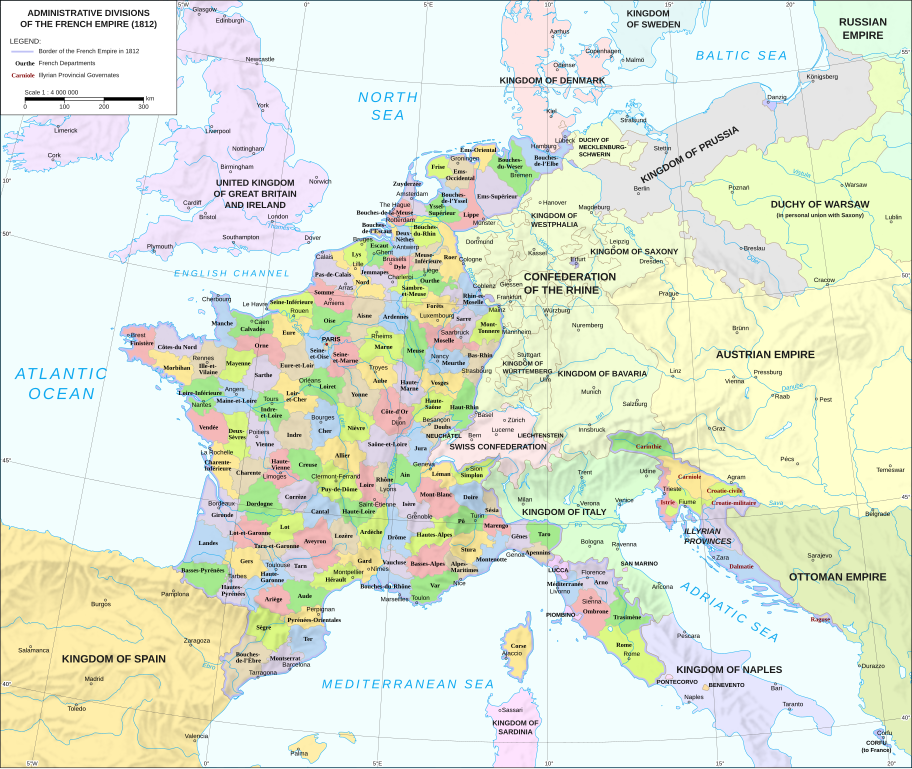
Català: Divisions administratives del Primer Imperi Francès el 1812
English: Administrative divisions of the First French Empire in 1812 |
| Date | |
| Source |
|
| Author | Andrein |
| Other versions |
Other related versions:[]
|


|
This SVG file contains embedded text that can be translated into your language, using any capable SVG editor, text editor or the SVG Translate tool. For more information see: About translating SVG files. |
This file is translated using SVG <switch> elements. All translations are stored in the same file! Learn more.
For most Wikipedia projects, you can embed the file normally (without a To translate the text into your language, you can use the SVG Translate tool. Alternatively, you can download the file to your computer, add your translations using whatever software you're familiar with, and re-upload it with the same name. You will find help in Graphics Lab if you're not sure how to do this. |
Licensing
[edit]
- You are free:
- to share – to copy, distribute and transmit the work
- to remix – to adapt the work
- Under the following conditions:
- attribution – You must give appropriate credit, provide a link to the license, and indicate if changes were made. You may do so in any reasonable manner, but not in any way that suggests the licensor endorses you or your use.
- share alike – If you remix, transform, or build upon the material, you must distribute your contributions under the same or compatible license as the original.
File history
Click on a date/time to view the file as it appeared at that time.
| Date/Time | Thumbnail | Dimensions | User | Comment | |
|---|---|---|---|---|---|
| current | 16:55, 16 June 2024 | | 2,052 × 1,728 (4.14 MB) | 밥풀떼기 (talk | contribs) | File uploaded using svgtranslate tool (https://svgtranslate.toolforge.org/). Added translation for ko. |
| 12:33, 9 February 2024 |  | 2,052 × 1,728 (3.86 MB) | Manlleus (talk | contribs) | added catalan language | |
| 17:10, 21 May 2021 |  | 2,052 × 1,728 (3.55 MB) | Andrei Stroe (talk | contribs) | File uploaded using svgtranslate tool (https://svgtranslate.toolforge.org/). Added translation for ro. | |
| 12:32, 30 August 2020 |  | 2,052 × 1,728 (3.24 MB) | Jfblanc (talk | contribs) | File uploaded using svgtranslate tool (https://svgtranslate.toolforge.org/). Added translation for oc. | |
| 10:37, 1 March 2018 |  | 2,052 × 1,728 (2.83 MB) | Imperator Honorius (talk | contribs) | Formatting Fix | |
| 10:29, 1 March 2018 |  | 2,052 × 1,728 (2.83 MB) | Imperator Honorius (talk | contribs) | Formatting and missing Anglicization (Gand to Ghent) | |
| 10:17, 1 March 2018 |  | 2,052 × 1,728 (2.83 MB) | Imperator Honorius (talk | contribs) | Spelling and typos; more Anglicised (and up to date) city names. | |
| 19:41, 20 July 2015 |  | 2,052 × 1,728 (2.82 MB) | ArdadN (talk | contribs) | spelling | |
| 17:11, 20 July 2015 |  | 2,052 × 1,728 (2.81 MB) | ArdadN (talk | contribs) | 1 | |
| 17:05, 20 July 2015 |  | 2,052 × 1,728 (2.81 MB) | ArdadN (talk | contribs) | font size |
You cannot overwrite this file.
File usage on Commons
The following 36 pages use this file:
- User:Geagea/Israel/2015 July 19
- User:Geagea/Israel/2015 July 20
- User:J budissin/Uploads/BiH/2018 March 1-10
- User:Magog the Ogre/Multilingual legend/2024 February 5-9
- User:Magog the Ogre/Multilingual legend/2024 June 16-20
- File:Apennins departement (1812).svg
- File:Arno departement (1812).svg
- File:Bouches-de-l'Elbe departement (1812).svg
- File:Bouches-de-l'Escaut departement (1812).svg
- File:Bouches-de-l'Yssel departement (1812).svg
- File:Bouches-de-la-Meuse departement (1812).svg
- File:Bouches-du-Rhin departement (1812).svg
- File:Bouches-du-Weser departement (1812).svg
- File:Dep-fr.svg (file redirect)
- File:Departamento de Bocas del Ebro (1812).svg
- File:Departamento de Montserrat (1812).svg
- File:Departamento de Ter (1812).svg
- File:Departamento del Segre (1812).svg
- File:Départments napoléoniens - sans noms des états.svg
- File:France L-1 (1812)-de.svg
- File:France L-2 (1812)-en.svg (file redirect)
- File:France L-2 (1812)-fr.svg (file redirect)
- File:Map administrative divisions of the First French Empire 1812-br.svg
- File:Map administrative divisions of the First French Empire 1812-de-big.svg
- File:Map administrative divisions of the First French Empire 1812-de.svg
- File:Map administrative divisions of the First French Empire 1812-el.svg
- File:Map administrative divisions of the First French Empire 1812-en.svg
- File:Map administrative divisions of the First French Empire 1812-es.svg
- File:Map administrative divisions of the First French Empire 1812-fr.svg
- File:Map administrative divisions of the First French Empire 1812-it.svg
- File:Map administrative divisions of the First French Empire 1812-mk.svg
- File:Map administrative divisions of the First French Empire 1812-zh.svg
- Template:Other versions/Map administrative divisions of the First French Empire 1812
.svg)
.svg)
.svg)
.svg)
.svg)
.svg)
.svg)
.svg)
-de.svg)
.svg)
.svg)
.svg)
.svg)
-en.svg&redirect=no)
-fr.svg&redirect=no)
File usage on other wikis
The following other wikis use this file:
- Usage on af.wikipedia.org
- Usage on ar.wikipedia.org
- Usage on ca.wikipedia.org
- Usage on en.wikipedia.org
- History of the Netherlands
- 1810s
- Departments of France
- 130 departments of the First French Empire
- Illyrian Provinces
- Kingdom of Italy (Napoleonic)
- Portal:Maps/Maps/Political
- Portal:Maps/Maps/Political/14
- First French Empire
- Bouches-del'Èbre
- Department of Segre
- Left Bank of the Rhine
- User:Dakaysaa/sandbox
- User:Falcaorib/France
- Usage on et.wikipedia.org
- Usage on fr.wikipedia.org
- Usage on hr.wikipedia.org
- Usage on it.wikipedia.org
- Usage on ka.wikipedia.org
- Usage on km.wikipedia.org
- Usage on krc.wikipedia.org
- Usage on no.wikipedia.org
- Usage on pl.wikipedia.org
- Usage on pnb.wikipedia.org
- Usage on pt.wikipedia.org
- Usage on ru.wikipedia.org
- Usage on tr.wikipedia.org
- Usage on ur.wikipedia.org
- Usage on vi.wikipedia.org