File:Dasht-e Lut Dust Storm Iran TMO 2010023 lrg.jpg
Jump to navigation
Jump to search

Size of this preview: 450 × 600 pixels. Other resolutions: 180 × 240 pixels | 360 × 480 pixels | 576 × 768 pixels | 768 × 1,024 pixels | 2,400 × 3,200 pixels.
Original file (2,400 × 3,200 pixels, file size: 1.35 MB, MIME type: image/jpeg)
Captions
Captions
Add a one-line explanation of what this file represents
Summary
[edit]
| Description |
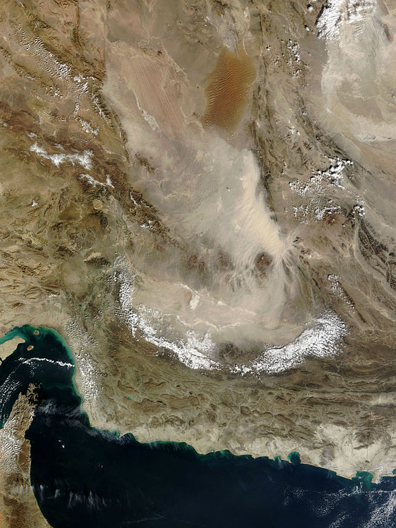
English: Pale tan dust billows over the Dasht-e Lut in eastern Iran, in this photo-like image from the Moderate Resolution Imaging Spectroradiometer (MODIS) on NASA’s Terra satellite. In the thickest part of the storm, the dust cloud blurs the texture of the land beneath it, revealing instead the texture of the air in waves and lines. The most distinctive waves surround Kuh-e Bazman, a 3,489-meter (11,450-foot) tall volcano, which rises above the dust cloud. The ripples in the dust are a reflection of turbulence created as air flows around the peak. The dust seeps into the valleys of the mountains south and east of the volcano.
The Dasht-e Lut, is a large salt desert in remote eastern Iran. The dust storm blows across the southern desert, leaving clear the distinctive orange dune fields and wind-swept lines in the north. |
| Date | |
| Source | http://earthobservatory.nasa.gov/NaturalHazards/view.php?id=42443&src=nha |
| Author | NASA |
== Assessment ==
|
Licensing
[edit]
| This file is in the public domain in the United States because it was solely created by NASA. NASA copyright policy states that "NASA material is not protected by copyright unless noted". (See Template:PD-USGov, NASA copyright policy page or JPL Image Use Policy.) | ||
 |
Warnings:
|
File history
Click on a date/time to view the file as it appeared at that time.
| Date/Time | Thumbnail | Dimensions | User | Comment | |
|---|---|---|---|---|---|
| current | 19:32, 27 January 2010 | | 2,400 × 3,200 (1.35 MB) | Captain-tucker (talk | contribs) | {{Information |Description={{en|Pale tan dust billows over the Dasht-e Lut in eastern Iran, in this photo-like image from the Moderate Resolution Imaging Spectroradiometer (MODIS) on NASA’s Terra satellite. In the thickest part of the storm, the dust cl |
You cannot overwrite this file.
File usage on Commons
There are no pages that use this file.
File usage on other wikis
The following other wikis use this file:
- Usage on af.wikipedia.org
- Usage on ckb.wikipedia.org
- Usage on cs.wikipedia.org
- Usage on fa.wikipedia.org
- دریای عمان
- دشت لوت
- بحث:دشت لوت
- تصویربرداری ماهوارهای
- ویکیپدیا:نگارههای برگزیده/نگاه به زمین
- ویکیپدیا:نگاره روز/ژوئن ۲۰۱۶
- ویکیپدیا:آیا میدانستید که...؟/هفتههای ۲۰۱۷ (میلادی)
- ویکیپدیا:آیا میدانستید که...؟/۲۰۱۷/هفته ۰۳
- ویکیپدیا:گزیدن نگاره برگزیده/Dasht-e Lut Dust Storm Iran TMO 2010023 lrg.jpg
- الگو:نر/2016-06-22
- الگو:نر محافظت شده/2016-06-22
- بحث ویکیپدیا:آیا میدانستید که...؟/۲۰۱۷/هفته ۰۳
- Usage on he.wikipedia.org
- Usage on mn.wikipedia.org
- Usage on sk.wikipedia.org