File:Dalmaziaitaliana.jpg
Jump to navigation
Jump to search
Size of this preview: 664 × 599 pixels. Other resolutions: 266 × 240 pixels | 532 × 480 pixels | 851 × 768 pixels | 1,150 × 1,038 pixels.
Original file (1,150 × 1,038 pixels, file size: 1.2 MB, MIME type: image/jpeg)
Captions
Captions
Add a one-line explanation of what this file represents
Summary
[edit]
| Description |
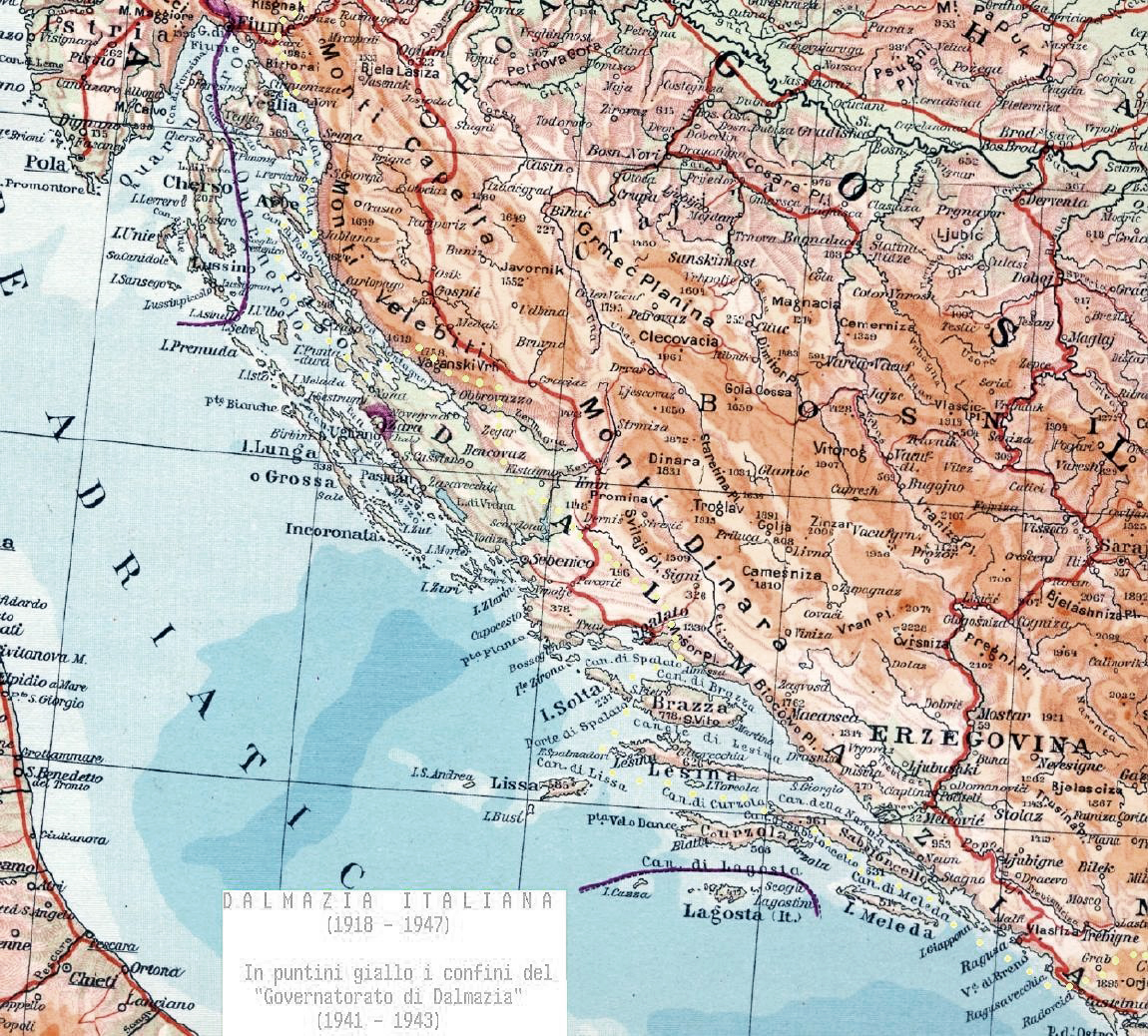
English: Italian Dalmatia. Borders of Italian Dalmatia between 1918 and 1947. Original map taken from italian "middle school" schoolbook of 1933 (GEOGRAFIA DEL REGNO D'ITALIA di Giacomo Stefanelli, EDITORIALE BALILLA, ROMA 1933, ANNO XI). I have added the borders (in yellow) of the Italian "Governatorate of Dalmatia" (1941-1943).
Italiano: Dalmazia italiana. Mappa presa da un testo scolastico di storia e geografa delle scuole medie italiane del 1933 (GEOGRAFIA DEL REGNO D'ITALIA di Giacomo Stefanelli, EDITORIALE BALILLA, ROMA 1933, ANNO XI). Ho aggiunto la dicitura e col mio computer ho segnato in giallo i confini del "Governatorato di Dalmazia" del Regno d'Italia (1941-1943) |
| Date | |
| Source | Opera creata dall'uploader (own work by uploader). Original source:GEOGRAFIA DEL REGNO D'ITALIA di Giacomo Stefanelli, EDITORIALE BALILLA, ROMA 1933, ANNO XI |
| Author | Brunodambrosio |
Licensing
[edit]
| I, the copyright holder of this work, release this work into the public domain. This applies worldwide. In some countries this may not be legally possible; if so: I grant anyone the right to use this work for any purpose, without any conditions, unless such conditions are required by law. |
File history
Click on a date/time to view the file as it appeared at that time.
| Date/Time | Thumbnail | Dimensions | User | Comment | |
|---|---|---|---|---|---|
| current | 15:05, 21 November 2013 | | 1,150 × 1,038 (1.2 MB) | DIREKTOR (talk | contribs) | Tone |
| 04:31, 21 July 2008 |  | 1,150 × 1,038 (341 KB) | Brunodambrosio (talk | contribs) | {{Information |Description={{en|1=Italian Dalmatia. Borders of Italian Dalmatia between 1918 and 1947. Original map taken from italian "middle school" schoolbook of 1933. I have added the borders (in yellow) of the Italian "Governatorate of Dalmatia" (194 |
You cannot overwrite this file.
File usage on Commons
There are no pages that use this file.
File usage on other wikis
The following other wikis use this file:
- Usage on ast.wikipedia.org
- Usage on bs.wikipedia.org
- Usage on en.wikipedia.org
- Usage on es.wikipedia.org
- Usage on hr.wikipedia.org
- Usage on it.wikipedia.org
- Usage on ja.wikipedia.org
- Usage on simple.wikipedia.org